Chico River (Lower Chubut)

Last updated
Chico River (Lower Chubut)

Chubut River Argentina basin map.png

Map of the Chubut drainage basin. Chico River is shown by the dotted line (lower right).
Country Argentina

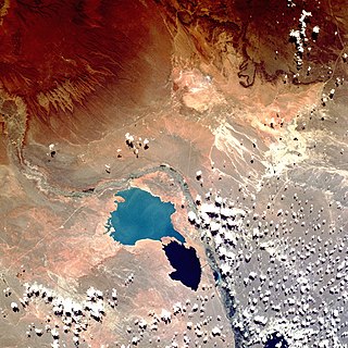
The Chico River is a river of Chubut Province, Argentina. It is about 300 kilometres (190 mi) long, flowing in a northeasterly direction from the vicinity of Lake Colhue Huapi. It is a tributary of the Chubut River, joining it at the Florentino Ameghino Dam.

Chubut Province Province of Argentina

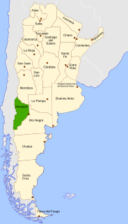
Chubut is a province in southern Argentina, situated between the 42nd parallel south, the 46th parallel south, the Andes range to the west, and the Atlantic ocean to the east. The province's name derives from the Tehuelche word chupat, meaning "transparent," their description of the Chubut River.

Argentina federal republic in South America

Argentina, officially named the Argentine Republic, is a country located mostly in the southern half of South America. Sharing the bulk of the Southern Cone with Chile to the west, the country is also bordered by Bolivia and Paraguay to the north, Brazil to the northeast, Uruguay and the South Atlantic Ocean to the east, and the Drake Passage to the south. With a mainland area of 2,780,400 km2 (1,073,500 sq mi), Argentina is the eighth-largest country in the world, the fourth largest in the Americas, and the largest Spanish-speaking nation. The sovereign state is subdivided into twenty-three provinces and one autonomous city, Buenos Aires, which is the federal capital of the nation as decided by Congress. The provinces and the capital have their own constitutions, but exist under a federal system. Argentina claims sovereignty over part of Antarctica, the Falkland Islands, and South Georgia and the South Sandwich Islands.

Before 1939 water from the Senguerr River entered the Chico via an outlet on the east side of Lake Colhue Huapi, but heavy use of water for irrigation has lowered the lake level and led to desiccation of the Chico river. The wide valley of the Chico is mostly dry today, except during periods of especially heavy snowmelt in the Andean headwaters of the Senguerr.

Senguerr River river in Argentina

The Senguerr River is a river of the Argentine province of Chubut. It begins its journey from the system of glacial lakes La Plata and Fontana in the Andes Mountains.

Irrigation artificial application of water to the land or soil

Irrigation is the application of controlled amounts of water to plants at needed intervals. Irrigation helps to grow agricultural crops, maintain landscapes, and revegetate disturbed soils in dry areas and during periods of less than average rainfall. Irrigation also has other uses in crop production, including frost protection, suppressing weed growth in grain fields and preventing soil consolidation. In contrast, agriculture that relies only on direct rainfall is referred to as rain-fed or dry land farming.

Andes mountain range running along the tu mamide of South America

The Andes or Andean Mountains are the longest continental mountain range in the world, forming a continuous highland along the western edge of South America. This range is about 7,000 km (4,300 mi) long, about 200 to 700 km wide, and of an average height of about 4,000 m (13,000 ft). The Andes extend from north to south through seven South American countries: Venezuela, Colombia, Ecuador, Peru, Bolivia, Chile and Argentina.

See also

Related Research Articles

The geography of Argentina describes the geographic features of Argentina, a country located in southern South America. Bordered by the Andes in the west and the South Atlantic Ocean to the east, neighboring countries are Chile to the west, Bolivia and Paraguay to the north, and Brazil and Uruguay to the northeast.

Neuquén Province Province of Argentina

Neuquén is a province of Argentina, located in the west of the country, at the northern end of Patagonia. It borders Mendoza Province to the north, Rio Negro Province to the southeast, and Chile to the west. It also meets La Pampa Province at its northeast corner.

Chubut River river in Argentina

The Chubut River is located in the Patagonia region of southern Argentina. Its name comes from the Tehuelche word chupat, which means "transparent". The Argentine Chubut Province, through which the river flows, is named after it. Welsh settlers called the river "Afon Camwy", meaning "twisting river".

<i>Luma apiculata</i> species of plant

Luma apiculata, the Chilean myrtle, is a species of flowering plant in the myrtle family, native to the central Andes between Chile and Argentina, at 33 to 45° south latitude. Growing to 10–15 m (33–49 ft) tall and wide, it is a vigorous, bushy, evergreen tree with fragrant flowers.

<i>Argyrosaurus</i> A genus of herbivorous titanosaurid dinosaur

Argyrosaurus is a genus of herbivorous titanosaurid dinosaur that lived about 90 million years ago, during the Late Cretaceous Period of what is now Argentina.

Neuquén Group

The Neuquén Group is a group of geologic formations found in Argentina. Rocks in the Neuquén Group fall within the Cenomanian to early Campanian stages of the Late Cretaceous Period. It overlies the older Lohan Cura Formation and is itself overlain by the younger Allen Formation of the Malargüe Group, separated from both by unconformities, dated to 98 and 79 Ma respectively.

Sarmiento, Chubut Town in Chubut, Argentina

Sarmiento is a town in the province of Chubut, Argentina. It has about 8,000 inhabitants as per the 2001 census [INDEC], and is the head town of the department of the same name. It is located on the so-called Central Corridor of Patagonia, in a fertile valley amidst an otherwise arid region, 140 km west from Comodoro Rivadavia, in the south of Chubut. It sits between two lakes, Lake Musters and Lake Colhue Huapi. Notable attractions are the Petrified Forest and caves with Aborigine hand paintings.

Río Senguer Department Place in Chubut, Argentina

Río Senguer Department is a department of Chubut Province in Argentina.

Alto Río Senguer Town in Chubut, Argentina

Alto Río Senguer, or Alto Río Senguerr, is a town in Chubut Province, Argentina located along the northern bank of the Senguerr River. It is the head town of the Río Senguer Department, and was formally founded on September 1, 1943. However, the first permanent dwelling on the site was built around 1915 by a German-born settler, for whom the village used to be named Schultz Pass.

Lake Musters and Lake Colhué Huapí

Lake Musters and lake Colhué Huapí form the terminal stage of the Senguerr river endorheic basin, located in the patagonic central region of Argentina in the south of Chubut province. Closest populated area is Sarmiento, an 8,000 inhabitant former Welsh immigrant colony. The lakes gave their names to the Mustersan and Colhuehuapian South American land mammal ages.

La Colonia Formation

The La Colonia Formation is a geological formation in Argentina whose strata date back to the Late Cretaceous. Dinosaur remains are among the fossils that have been recovered from the formation.

The Guenguel River is a river of Argentina in Chubut province. It is tributary to the Senguerr river.

Laguna Palacios Formation

The Laguna Palacios Formation is a Maastrichtian geologic formation of the Chubut Group in the Golfo San Jorge Basin in Patagonia, Argentina. The formation partly overlies and partly is laterally equivalent to the Lago Colhué Huapí Formation and is overlain by the Salamanca Formation of the Río Chico Group. The formation comprises tuff reworked by fluvial activity and paleosols. The Laguna Palacios Formation has provided fossilized bee nests. Dinosaur remains diagnostic to the genus level are among the fossils that have been recovered from the formation.

Chico River may refer to:

Comahuetherium is an extinct genus of astrapotherian mammal from the Early Miocene. It is a basal astrapotheriid which lived in what is now Patagonia, Argentina. The holotype was found in the Cerro Bandera Formation in Neuquén Province, northern Patagonia and additional specimens were found at the Gran Barranca south of Lake Colhué Huapi, in Chubut Province of central Patagonia. It was first named by Alejandro Kramarz and Mariano Bond in 2011 and the type species is Comahuetherium coccaorum.

Maddenia is an extinct genus of astrapothere, meridiungulate herbivore mammals characterised by its large tusks and the development of proboscis, endemic of South America. This genus was discovered in an outcrop near to the Lake Colhué Huapi in the place La Cantera, in the Chubut Province, in Argentina, in sediments corresponding to the Sarmiento Formation, that dates of the Late Oligocene.

Golfo San Jorge Basin

The Golfo San Jorge Basin is a hydrocarbon-rich sedimentary basin located in eastern Patagonia, Argentina. The basin covers the entire San Jorge Gulf and an inland area west of it, having one half located in Santa Cruz Province and the other in Chubut Province. The northern boundary of the basin is the North Patagonian Massif while the Deseado Massif forms the southern boundary of the basin. The basin has largely developed under condition of extensional tectonics, including rifting.

Sektensaurus is a genus of possibly elasmarian ornithopod dinosaur from the Late Cretaceous fluvial tuffs of the Lago Colhué Huapí Formation in the Golfo San Jorge Basin of Patagonia, Argentina. The type and only species is S. sanjuanboscoi. Sektensaurus is the first non-hadrosaurid ornithopod of central Patagonia. The discovery of the genus increases the anatomical knowledge of ornithopods and adds new data on the compositions of dinosaur faunas that lived in Patagonia close to Antarctica at the end of the Cretaceous.

Lago Colhué Huapí Formation

The Lago Colhué Huapí Formation is a Late Cretaceous geologic formation of the Chubut Group in the Golfo San Jorge Basin in Patagonia, Argentina. The formation, named after Lake Colhué Huapí, is overlain by the Salamanca Formation of the Río Chico Group and in some areas by the Laguna Palacios Formation.

References