
The Rhine is one of the major European rivers. The river begins in the Swiss canton of Graubünden in the southeastern Swiss Alps. It forms the Swiss-Liechtenstein border and partly the Swiss-Austrian and Swiss-German borders. After that the Rhine defines much of the Franco-German border, after which it flows in a mostly northerly direction through the German Rhineland. Finally in Germany, the Rhine turns into a predominantly westerly direction and flows into the Netherlands where it eventually empties into the North Sea. It drains an area of 9,973 km2.

The Uinta Mountains are an east-west trending mountain range in northeastern Utah extending a short distance into northwest Colorado and slightly into southwestern Wyoming in the United States. As a subrange of the Rocky Mountains, they are unusual for being the highest range in the contiguous United States running east to west, and lie approximately 100 miles (160 km) east of Salt Lake City. The range has peaks ranging from 11,000 to 13,528 feet, with the highest point being Kings Peak, also the highest point in Utah. The Mirror Lake Highway crosses the western half of the Uintas on its way to Wyoming. Utah State Route 44 crosses the east end of the Uintas between Vernal and Manila.
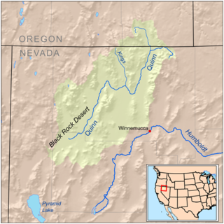
The Kings River is a tributary of the Quinn River, about 40 mi (64 km) long, in northwestern Nevada and south-central Oregon in the United States. It drains a remote arid area of the northwestern Great Basin.
Fundin is a lake in the municipalities of Folldal in Innlandet county and Oppdal in Trøndelag county, Norway. The 9.72-square-kilometre (3.75 sq mi) lake has a dam at the south end of it, holding back the water for hydroelectric power production, before letting it flow into the Einunna river.
The Miami River is a 13.7-mile-long (22.0 km) stream in upstate New York and is a part of the Hudson River watershed. The river's headwaters rise in the Adirondack Mountains at 43°36′11″N74°30′12″W about 10 miles (16 km) northwest of Speculator and flows southeast for about 3 miles (5 km) with Pillsbury Mountain on the southwest and Page Mountain to the northeast. It turns sharply southwest for about one mile and then turns sharply east for about a mile, after which it flows mostly northeast for about 8 miles (13 km) before flowing into Lewey Lake at 43°37′58″N74°24′17″W. Lewey Lake empties into Indian Lake, which is drained by the Indian River, which then flows into the Hudson River approximately 17 miles (27 km) to the northeast of Lewey Lake.

The Laurentide ice sheet was a massive sheet of ice that covered millions of square miles, including most of Canada and a large portion of the Northern United States, multiple times during the Quaternary glacial epochs, from 2.58 million years ago to the present.

General Carrera Lake or Lake Buenos Aires is a deep lake located in Patagonia and shared by Argentina and Chile. Both names are internationally accepted, while the autochthonous name of the lake is Chelenko, which means "stormy waters" in Aonikenk. Another historical name is Coluguape from Mapuche, a derivative of this name is applied to Colhué Huapí Lake after Argentine explorer Francisco Moreno reached this lake in 1876 conflating it with Coluguape.
The Chowchilla River is a river in central California, United States and a minor tributary of the San Joaquin River. It flows for 54.2 miles (87.2 km) from the western side of the Sierra Nevada Range to the San Joaquin River system in the San Joaquin Valley.

Oppstrynsvatn is a lake in the municipality of Stryn in Vestland county, Norway. It is located about 8 kilometres (5.0 mi) east of the village of Stryn. The villages of Flo, Oppstryn, and Erdal are located on the shores of the lake.
Austdalsvatnet is a lake in the northwestern part of Luster Municipality in Vestland county, Norway. It is located in the Breheimen mountain range at the end of the Austdalsbreen glacier, just north of the lake Styggevatnet. It is about 10 kilometres (6.2 mi) east of Lodalskåpa and Brenibba, in the Jostedalsbreen glacier. The water is regulated by a dam on lake Styggevatnet and it empties into the Jostedøla river which flows south into the Gaupnefjord.

The Bearcamp River is a 26.3-mile-long (42.3 km) river at the southern edge of the White Mountains in New Hampshire, the United States. It is the largest tributary of Ossipee Lake, part of the Saco River watershed leading to the Atlantic Ocean.

U-shaped valleys, also called trough valleys or glacial troughs, are formed by the process of glaciation. They are characteristic of mountain glaciation in particular. They have a characteristic U shape in cross-section, with steep, straight sides and a flat or rounded bottom. Glaciated valleys are formed when a glacier travels across and down a slope, carving the valley by the action of scouring. When the ice recedes or thaws, the valley remains, often littered with small boulders that were transported within the ice, called glacial till or glacial erratic.
The Little Magalloway River is a 7.0-mile-long (11.3 km) river in northwestern Maine and northern New Hampshire in the United States. It is a tributary of the Magalloway River, located in the Androscoggin River watershed of Maine and New Hampshire.

Lovatnet is a lake in the municipality of Stryn in Vestland county, Norway. It is located about 2 kilometres (1.2 mi) southeast of the village of Loen and about 6 kilometres (3.7 mi) east of the village of Olden. The lake lies just 2 kilometres (1.2 mi) southwest of the mountain Skåla. The water from the lake flows down from the mountains; especially from the Jostedalsbreen and Tindefjellbreen glaciers. It then flows out through the Loelva river into the Nordfjorden.
The Dan Hole River is a 5.1-mile-long (8.2 km) river in the town of Ossipee in eastern New Hampshire in the United States. Its waters flow via the Beech River, Pine River, Ossipee Lake, the Ossipee River, and the Saco River to the Gulf of Maine, an arm of the Atlantic Ocean.
Eikesdalsvatnet is a lake in Molde Municipality in Møre og Romsdal county, Norway. The lake is long and narrow, roughly 18 kilometres (11 mi) in length, and it is the largest lake in Møre og Romsdal county. The village of Eikesdalen is located at the southern end of the lake. Average depth is 89 meters such that most of the lake's volume is below sea level.

The Sebec River is a tributary of the Piscataquis River in Piscataquis County, Maine. From the outflow of Sebec Lake in Sebec, the river runs 10.0 miles (16.1 km) east and southeast to its confluence with the Piscataquis in Milo.

Kiwira River is a river located in Rungwe District and Kyela District of Mbeya Region, Tanzania.
Songavatnet is a lake in Vinje Municipality in Telemark county, Norway. It has a surface area of 29.86 square kilometres (11.53 sq mi) and lies at an elevation of 974 metres (3,196 ft). The lake lies just south of the border of Hardangervidda National Park and just southeast of the mountain Vassdalseggi. The villages of Haukeli and Edland are both located about 9 kilometres (5.6 mi) to the south of the lake and the village of Arabygdi lies about 10 kilometres (6.2 mi) to the southeast of the lake. The lake flows out into the river Songa which flows to the southeast into the nearby lake Totak.

Lake Musters is located in the central Patagonian region of the Argentine Republic, south of the province of Chubut, and together with Lake Colhué Huapi forms the terminal phase of the current endorheic basin of the Senguerr River. Both lakes are located in the Valle de Sarmiento.
