
The Alps are one of the highest and most extensive mountain ranges in Europe, stretching approximately 1,200 km (750 mi) across eight Alpine countries : Monaco, France, Switzerland, Italy, Liechtenstein, Germany, Austria and Slovenia.

The Carpathian Mountains or Carpathians are a range of mountains forming an arc across Central Europe and Southeast Europe. Roughly 1,500 km (930 mi) long, it is the third-longest European mountain range after the Urals at 2,500 km (1,600 mi) and the Scandinavian Mountains at 1,700 km (1,100 mi). The range stretches from the eastern edge of the Czech Republic (3%) and Austria (1%) in the northwest through Slovakia (21%), Poland (10%), Ukraine (10%), Romania (50%) to Serbia (5%) in the south. The highest range within the Carpathians is known as the Tatra Mountains in Poland and Slovakia, where the highest peaks exceed 2,600 m (8,500 ft). The second-highest range is the Southern Carpathians in Romania, where the highest peaks range between 2,500 m (8,200 ft) and 2,550 m (8,370 ft).

The Cascade Range or Cascades is a major mountain range of western North America, extending from southern British Columbia through Washington and Oregon to Northern California. It includes both non-volcanic mountains, such as many of those in the North Cascades, and the notable volcanoes known as the High Cascades. The small part of the range in British Columbia is referred to as the Canadian Cascades or, locally, as the Cascade Mountains. The highest peak in the range is Mount Rainier in Washington at 14,411 feet (4,392 m).

The Karakoram is a mountain range in the Kashmir region spanning the border of Pakistan, China, and India, with the northwestern extremity of the range extending to Afghanistan and Tajikistan. Most of the Karakoram mountain range falls under the jurisdiction of Gilgit-Baltistan, which falls within the Kashmir region administered by Pakistan

James Felix Bridger was an American mountain man, trapper, Army scout, and wilderness guide who explored and trapped in the Western United States in the first half of the 19th century. He was known as Old Gabe in his later years. He was from the Bridger family of Virginia, English settlers who had been in North America since the early colonial period.

The Canadian Rockies or Canadian Rocky Mountains, comprising both the Alberta Rockies and the British Columbian Rockies, is the Canadian segment of the North American Rocky Mountains. It is the easternmost part of the Canadian Cordillera, which is the northern segment of the North American Cordillera, the expansive system of interconnected mountain ranges between the Interior Plains and the Pacific Coast that runs northwest–southeast from central Alaska to the Isthmus of Tehuantepec in Mexico.

The Balkan mountain range is located in the eastern part of the Balkans in Southeastern Europe. The range is conventionally taken to begin at the peak of Vrashka Chuka on the border between Bulgaria and Serbia. It then runs for about 560 kilometres (350 mi), first in a south-easterly direction along the border, then eastward across Bulgaria, forming a natural barrier between the northern and southern halves of the country, before finally reaching the Black Sea at Cape Emine. The mountains reach their highest point with Botev Peak at 2,376 metres (7,795 ft).

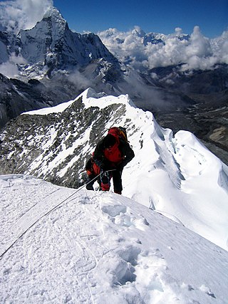
A mountain pass is a navigable route through a mountain range or over a ridge. Since mountain ranges can present formidable barriers to travel, passes have played a key role in trade, war, and both human and animal migration throughout history. At lower elevations it may be called a hill pass. A mountain pass is typically formed between two volcanic peaks or created by erosion from water or wind.

Crowsnest Pass is a low mountain pass across the Continental Divide of the Canadian Rockies on the Alberta–British Columbia border.

Mount Kailash is a mountain in Ngari Prefecture, Tibet Autonomous Region of China. It lies in the Kailash Range of the Transhimalaya, in the western part of the Tibetan Plateau. The peak of Mount Kailash is located at an elevation of 6,638 m (21,778 ft), near the western trijunction between China, India and Nepal.

The Santa Monica Mountains are a coastal mountain range in Southern California, next to the Pacific Ocean. It is part of the Transverse Ranges. The Santa Monica Mountains National Recreation Area encompasses this mountain range. Because of its proximity to densely populated regions, it is one of the most visited natural areas in California.

The Transverse Ranges are a group of mountain ranges of southern California, in the Pacific Coast Ranges physiographic region in North America. The Transverse Ranges begin at the southern end of the California Coast Ranges and lie within Santa Barbara, Ventura, Los Angeles, San Bernardino, Riverside and Kern counties. The Peninsular Ranges lie to the south. The name is due to the ranges' east–west orientation, making them transverse to the general northwest–southeast orientation of most of California's coastal mountains.

The Pacific Time Zone (PT) is a time zone encompassing parts of western Canada, the western United States, and western Mexico. Places in this zone observe standard time by subtracting eight hours from Coordinated Universal Time (UTC−08:00). During daylight saving time, a time offset of UTC−07:00 is used.
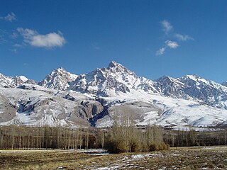
The Taurus Mountains are a mountain complex in southern Turkey, separating the Mediterranean coastal region from the central Anatolian Plateau. The system extends along a curve from Lake Eğirdir in the west to the upper reaches of the Euphrates and Tigris rivers in the east. It is a part of the Alpide belt in Eurasia.
A summit is a point on a surface that is higher in elevation than all points immediately adjacent to it. The topographic terms acme, apex, peak, and zenith are synonymous.

The Sangre de Cristo Mountains are the southernmost subrange of the Rocky Mountains. They are located in southern Colorado and northern New Mexico in the United States. The mountains run from Poncha Pass in South-Central Colorado, trending southeast and south, ending at Glorieta Pass, southeast of Santa Fe, New Mexico. The mountains contain a number of fourteen thousand foot peaks in the Colorado portion, as well as several peaks in New Mexico which are over thirteen thousand feet.

The Yellowhead Pass is a mountain pass across the Continental Divide of the Americas in the Canadian Rockies. It is on the provincial boundary between the Canadian provinces of Alberta and British Columbia, and lies within Jasper National Park and Mount Robson Provincial Park.

Howse Pass is a pass through the Rocky Mountains in Canada. The pass is located in Banff National Park, between Mount Conway and Howse Peak. From here waters flow east via Conway Creek, Howse River, North Saskatchewan River to Lake Winnipeg and Hudson Bay. To the west it drains by the Blaeberry River to the Columbia River and on to the Pacific Ocean.
Fortress Pass is a mountain pass that crosses the continental divide in the Canadian Rockies, south of Jasper, Alberta. At 1,335 metres (4,380 ft), Fortress Pass is one of the lowest passes to cross the Canadian Rockies that is not traversed by a road. In addition to being at a low elevation, Fortress Pass is also relatively gentle, with almost no elevation difference between water bodies on either side.
