
Torridge is a local government district in north-west Devon, England. Its council is based in the town of Bideford. The district also includes the towns of Great Torrington, Holsworthy and Northam, along with numerous villages and surrounding rural areas. The island of Lundy forms part of the district. The district is named after the River Torridge.
Black Torrington is a village and civil parish in Torridge, Devon, England, situated between the towns of Holsworthy and Hatherleigh. It is located on and named after the River Torridge.

Thornbury is a small village and civil parish in the local government district of Torridge, Devon, England. The parish, which lies about five miles (8 km) north-east of the town of Holsworthy, comprises the five hamlets of Thornbury, Woodacott, Brendon, Lashbrook and South Wonford. These five hamlets are spread over an area of some 6 square miles (16 km2), with a distance of three miles (5 km) from Brendon to Thornbury Church. Hence, the community is quite widespread, with the only focal point being the Green at Woodacott Cross. The parish is surrounded clockwise from the north by the parishes of Milton Damerel, Bradford, Cookbury and Holsworthy Hamlets. In 2011, its population was 290, in 120 households, little changed from the 291 residents it had in 1901.

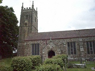
Holsworthy is a market town and civil parish in the Torridge district of Devon, England, 36 miles (58 km) west of Exeter. The River Deer, a tributary of the River Tamar, forms the western boundary of the parish, which includes the village of Brandis Corner. According to the 2011 census the population of Holsworthy was 2,641; it was estimated at 3,287 in 2019.

Cookbury is a village and civil parish in the local government district of Torridge, Devon, England. The parish, which lies about five miles east of the town of Holsworthy, is surrounded clockwise from the north by the parishes of Thornbury, Bradford, Ashwater, Hollacombe, and Holsworthy Hamlets. In 2001 its population was 158, little changed from the 146 residents it had in 1901.
Broadwoodwidger was a rural district in the administrative county of Devon from 1894 to 1966, northeast of Launceston. The district consisted of part of the Launceston rural sanitary district in Devon. The remainder of the sanitary district became Launceston Rural District in Cornwall.
Holsworthy Association Football Club is a football club based in Holsworthy, Devon, England. They play in the South West Peninsula League Premier Division West.

The Lyd is a river rising at Lyd Head in the Dartmoor national park in Devon in South West England and flowing into the River Tamar beyond Lifton. It runs through Lydford Gorge, the deepest gorge in South West England.
The Okehampton–Bude line was a railway line built to serve Holsworthy in Devon, and Bude on the Cornish coast near the Devon border in England. The line branched from the main line at Meldon Junction to the west of Okehampton on the northern edge of Dartmoor. The line opened in 1879 to Holsworthy and in 1898 to Bude. It is now closed.

Bradford is a village and civil parish in the local government district of Torridge, Devon, England. The parish, which lies about six miles east of the town of Holsworthy has part of its eastern boundary formed by the River Torridge, and it is surrounded clockwise from the north by the parishes of Milton Damerel, Shebbear, Black Torrington, Ashwater, Cookbury and Thornbury. In 2001 its population was 359, compared to 280 in 1901.

Woodacott is a small village in Devon, England. The nearest shops are in Holsworthy, about four miles to the south-west of Woodacott. The village is less than a ¼ mile to the west of Woodacott Cross, and they are normally regarded as the same village.

Ruby Country is the name given to the rural inland hinterland of north-west Devon, UK. It covers 45 parishes around the market towns of Holsworthy and Hatherleigh. These two towns were at the centre of the 2001 Foot and Mouth Disease outbreak, and although agriculture was directly affected, most local businesses suffered considerable financial hardship.

Pyworthy is a village and civil parish in the far west of Devon, England. It forms part of the local government district of Torridge. The parish lies to the west of the town of Holsworthy. It is surrounded clockwise from the north-west by the parishes of Bridgerule, a small part of Pancrasweek, Holsworthy Hamlets and Holsworthy, and Clawton. Its western border follows the River Tamar which forms the county boundary with Cornwall. In 2001 its population was 689, up from 429 in 1901.

Holsworthy Hamlets is a civil parish in the northwest of Devon, England. It forms part of the local government district of Torridge and came into being on 1 April 1900 when the ecclesiastical parish of Holsworthy was split into two.

Hollacombe is a village and small civil parish in the local government district of Torridge, Devon, England. It lies about 3 miles south east of the town of Holsworthy and is surrounded clockwise from the north by the parishes of Cookbury, Ashwater, and Holsworthy Hamlets. In 2001 its population was 59, compared to 69 in 1901.

Pancrasweek is a village and civil parish and hamlet in the far west of Devon, England forming part of the local government district of Torridge and lying about three miles north west of the town of Holsworthy.

East Putford is a small settlement and civil parish in the local government district of Torridge, Devon, England. The parish, which lies about halfway between the towns of Holsworthy and Bideford, is surrounded clockwise from the north by the parishes of Parkham, Buckland Brewer, Bulkworthy, West Putford, and Woolfardisworthy. In 2001 its population was 103, slightly lower than the 125 residents it had in 1901.

West Putford is a small settlement and civil parish in the local government district of Torridge, Devon, England. The parish, which lies about 8.5 miles (13.7 km) north of the town of Holsworthy, is surrounded clockwise from the north by the parishes of East Putford, a small part of Bulkworthy, Abbots Bickington, Sutcombe, Bradworthy and Woolfardisworthy. In 2001 its population was 181, compared to 216 in 1901. The eastern and northern boundaries of the parish mostly follow the River Torridge over which is the 13th-century Kismeldon Bridge. Tumuli on the high ground provide evidence for early inhabitants here.

Sutcombe is a village and civil parish in the local government district of Torridge, Devon, England. The parish, which lies about 5.5 miles north of the town of Holsworthy, is surrounded clockwise from the north by the parishes of West Putford, Abbots Bickington, Milton Damerel, Holsworthy Hamlets and Bradworthy. In 2001 its population was 299, compared to 351 in 1901.

The River Carey is a small river in West Devon that is a tributary to the River Tamar.
