
Peters Marland is a small village and civil parish in the local government district of Torridge, Devon, England. The parish, which lies about four miles south of the town of Great Torrington, is surrounded clockwise from the north by the parishes of Little Torrington, Merton, Petrockstowe, Buckland Filleigh, Shebbear and Langtree. In 2001 its population was 234, down from the 286 residents it had in 1901.

Thornbury is a small village and civil parish in the local government district of Torridge, Devon, England. The parish, which lies about five miles (8 km) north-east of the town of Holsworthy, comprises the five hamlets of Thornbury, Woodacott, Brendon, Lashbrook and South Wonford. These five hamlets are spread over an area of some 6 square miles (16 km2), with a distance of three miles (5 km) from Brendon to Thornbury Church. Hence, the community is quite widespread, with the only focal point being the Green at Woodacott Cross. The parish is surrounded clockwise from the north by the parishes of Milton Damerel, Bradford, Cookbury and Holsworthy Hamlets. In 2011, its population was 290, in 120 households, little changed from the 291 residents it had in 1901.

Holsworthy is a market town and civil parish in the Torridge district of Devon, England, 36 miles (58 km) west of Exeter. The River Deer, a tributary of the River Tamar, forms the western boundary of the parish, which includes the village of Brandis Corner. According to the 2011 census the population of Holsworthy was 2,641; it was estimated at 3,287 in 2019.

Abbots Bickington is a village and civil parish in the English county of Devon, located 7.7 mi (12.4 km) north-northeast of Holsworthy and near the River Torridge.
Buckland Filleigh is a village, civil parish and former manor in the Torridge district of North Devon, England, situated about 8 miles south of the town of Great Torrington. According to the 2001 census, the parish had a population of 170. It is surrounded clockwise from the north by the parishes of Peters Marland, Petrockstowe, Highampton, Sheepwash and Shebbear.

Bradford is a village and civil parish in the local government district of Torridge, Devon, England. The parish, which lies about six miles east of the town of Holsworthy has part of its eastern boundary formed by the River Torridge, and it is surrounded clockwise from the north by the parishes of Milton Damerel, Shebbear, Black Torrington, Ashwater, Cookbury and Thornbury. In 2001 its population was 359, compared to 280 in 1901.

Frithelstock is a village, civil parish and former manor in Devon, England. It is located within Torridge local authority area and formed part of the historic Shebbear hundred. The parish is surrounded, clockwise from the north, by the parishes of Monkleigh, Great Torrington, Little Torrington, Langtree and Buckland Brewer. In 2001 its population was 366, down from 429 in 1901.

Pyworthy is a village and civil parish in the far west of Devon, England. It forms part of the local government district of Torridge. The parish lies to the west of the town of Holsworthy. It is surrounded clockwise from the north-west by the parishes of Bridgerule, a small part of Pancrasweek, Holsworthy Hamlets and Holsworthy, and Clawton. Its western border follows the River Tamar which forms the county boundary with Cornwall. In 2001 its population was 689, up from 429 in 1901.
Tetcott is a civil parish, small settlement and former manor in Devon, England. The parish lies about five miles south of the town of Holsworthy and is bordered on the north by the parish of Clawton, on the east by a small part of Ashwater, and on the south by Luffincott. It forms part of the local government district of Torridge, and its western boundary is the River Tamar which forms the Cornish border. In 2001 its population was 110, half that of a century earlier.
Milton Damerel is a village, parish and former manor in north Devon, England. Situated in the political division of Torridge, on the river Waldon, it covers 7 square miles (18 km2). It contains many tiny hamlets including Whitebeare, Strawberry Bank, East Wonford and West Wonford. The parish has a population of about 450. The village is situated about 5 miles (8.0 km) from Holsworthy, 13.081 miles (21.052 km) from Bideford and 22.642 miles (36.439 km) from Barnstaple. The A388 is the main road through the parish.

Annery was an historic estate in the parish of Monkleigh, North Devon.

John Arscott (1613-1675), of Tetcott, Devon, was Sheriff of Devon in 1675.

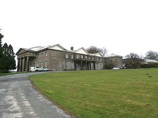
Dunsland is a historic manor and former house in the parish of Bradford near Holsworthy in Devon, England. It was successively home to the Arscott, Bickford, Coham and Dickinson families and, although the ownership records are incomplete, it is very likely that the estate passed in an unbroken line from the time of the Norman Conquest until 1947. The house was destroyed by fire in 1967, just after extensive restoration by the National Trust.

Clawton is a village and civil parish in the far west of Devon, England. It forms part of the local government district of Torridge. The village lies about three miles south of the town of Holsworthy on the A388 road. The parish is surrounded clockwise from the north-west by the parishes of Pyworthy, Holsworthy Hamlets, Ashwater, and Tetcott. Its western border follows the River Tamar which forms the county boundary with Cornwall. In 2001 its population was 326, slightly down from 389 in 1901.

Luffincott is a civil parish in the far west of Devon, England. It forms part of the local government district of Torridge and lies about six miles south of the town of Holsworthy. The parish is surrounded clockwise from the north by the parishes of Tetcott, Ashwater, St Giles on the Heath and Northcott. Its western border follows the River Tamar which forms the county boundary with Cornwall.

Hollacombe is a village and small civil parish in the local government district of Torridge, Devon, England. It lies about 3 miles south east of the town of Holsworthy and is surrounded clockwise from the north by the parishes of Cookbury, Ashwater, and Holsworthy Hamlets. In 2001 its population was 59, compared to 69 in 1901.

Pancrasweek is a village and civil parish and hamlet in the far west of Devon, England forming part of the local government district of Torridge and lying about three miles north west of the town of Holsworthy.

Sutcombe is a village and civil parish in the local government district of Torridge, Devon, England. The parish, which lies about 5.5 miles north of the town of Holsworthy, is surrounded clockwise from the north by the parishes of West Putford, Abbots Bickington, Milton Damerel, Holsworthy Hamlets and Bradworthy. In 2001 its population was 299, compared to 351 in 1901.

Huxham is a hamlet and civil parish in the county of Devon, England and the district of East Devon and lies about 3 miles from Exeter. The parish has an area of about 800 acres and is surrounded, clockwise from the north, by Rewe, Poltimore, Exeter and Stoke Canon. It is too small to have a parish council and instead has a parish meeting. It was formerly part of the Wonford Hundred and gave its name to a family who possessed the manor from the reign of Henry II to that of Edward III. The manor was then held by the Bampfylde family of Poltimore.


