Related Research Articles
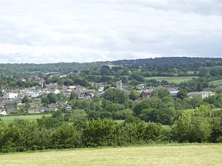
Axminster is a market town and civil parish on the eastern border of the county of Devon in England. It is 28 miles (45 km) from the county town of Exeter. The town is built on a hill overlooking the River Axe which heads towards the English Channel at Axmouth, and is in the East Devon local government district. At the 2001 census, it had a population of 5,626, increasing to 5,761 at the 2011 census. The town contains two electoral wards whose combined population is 7,110. The market is still held every Thursday.

Slapton is a village and civil parish in the South Hams district of Devon, England. It is located near the A379 road between Kingsbridge and Dartmouth, and lies within the South Devon Area of Outstanding Natural Beauty (AONB). The nearby beach is Slapton Sands; despite its name, it is not a sandy beach but a shingle one.
All Saints is a civil parish in East Devon, Devon, England. It has a population of 498 according to the 2001 census. The parish includes the hamlets of All Saints, Smallridge, Churchill, Alston and Waggs Plot. This area also has one cricket pitch, a primary school, pre-school and a church.
Ashton is a civil parish in the Teignbridge district of Devon, England. According to the 2001 census it had a population of 174, and it had a population of 203 according to the 2011 census. The parish consists of two villages, Higher Ashton and Lower Ashton, and is on the edge of the Dartmoor National Park. The France Brook flows through most of Ashton just south of its main road, and along Ashton's eastern boundary flows the River Teign. The parish is located approximately 13 km north of Newton Abbot, and roughly 10 km to the south west of its nearest city, Exeter. Historically, Ashton has primarily been based inside the agricultural sector, but one of its most notifiable landmarks is the St John the Baptists church located in the Higher Ashton district.
Bondleigh is a village and civil parish in the West Devon district of Devon, England, on the River Taw, north of North Tawton. According to the 2011 census it had a population of 167.

Willand is a village and civil parish in Mid Devon, England. It is about 19 km (12 mi) north of Exeter and 2.4 km (1.5 mi) north of Cullompton. In 1991 the population was 3750 although recently this has grown considerably. The National Grid reference for the centre of the area is ST037110. Willand is a major part of Lower Culm electoral ward. The ward population at the 2011 Census was 5,808. The parish is surrounded, clockwise from the north, by the parishes of Halberton, Uffculme and Cullompton.

Buckland Monachorum is a village and civil parish in the West Devon district of Devon, England, situated on the River Tavy, about 10 miles north of Plymouth.

Uffculme is a village and civil parish located in the Mid Devon district, of Devon, England. Situated in the Blackdown Hills on the B3440, close to the M5 motorway and the Bristol–Exeter railway line, near Cullompton, Uffculme is on the upper reaches of the River Culm. The population of the parish, according to a 2020 estimate, is 3,090. It is surrounded, clockwise from the north, by the parishes of Culmstock, Hemyock, Sheldon, Kentisbeare, Cullompton, Willand, Halberton and Burlescombe.

Oakford is a village and civil parish in the Mid Devon district of Devon, England. It is located three miles (5 km) south west of Bampton and eight miles (13 km) north north west of Tiverton. Oakford is near the river Exe.

Heanton Punchardon ( ) is a village, civil parish and former manor, anciently part of Braunton Hundred. It is situated directly east-southeast of the village of Braunton, in North Devon. The parish lies on the north bank of the estuary of the River Taw and it is surrounded, clockwise from the north, by the parishes of Braunton, Marwood, Ashford and across the estuary, Fremington. The population was 418 in 1801 and 404 in 1901. Its largest localities are Wrafton and Chivenor. The surrounding area is also an electoral ward with a total population at the 2011 census of 2,673.

Cheriton Bishop is a village and civil parish situated on the northern borders of Dartmoor National park between Exeter and Okehampton, in Devon, England. The population at the 2011 Census was 652. The history of the settlement can be traced back over a thousand years when the old village centre was established as a commercial centre for the local farming community.

Rousdon is a village and former civil parish, now in the parish of Combpyne Rousdon, in the East Devon district, in the county of Devon, England. It is off the A3052 road between Colyford and Lyme Regis in Dorset. In 1931 the parish had a population of 41. On 1 April 1939 the parish was abolished to form "Combpyne Rousdon".

Combpyne is a village and former civil parish, now in the parish of Combpyne Rousdon, in the East Devon district, in the county of Devon, England. It is off the A3052 road between Colyford and Lyme Regis in Dorset. In 1931 the parish had a population of 83. On 1 April 1939 the parish was abolished to form "Combpyne Rousdon".
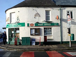
Stoke Canon is a small village and civil parish near the confluence of the rivers Exe and Culm on the main A396 between Exeter and Tiverton in the English county of Devon, and the district of East Devon. At the 2001 census, it had a population of 660. The population was unchanged in 2011 but the village forms the major part of the Exe Valley electoral ward. The population of this ward was 2,041 at the 2011 Census.

Witheridge is a village and civil parish in the North Devon district of Devon, England. In 2001 the population of the parish was 1162, reducing slightly to 1,158 at the 2011 Census. An electoral ward with the same name exists. The population at the above census was 2,313. Its name may be derived from the Old English for "Weather Ridge", which would fit with the village's somewhat exposed situation.

Lanteglos is a coastal civil parish in south Cornwall, England, United Kingdom. It is on the east side of the tidal estuary of the River Fowey which separates it from the town and civil parish of Fowey. The South West Coast Path runs along the southern coasts of the parish and much of the southern part of the parish lies in the Polruan to Polperro Site of Special Scientific Interest managed by the National Trust.
The hundred of Axminster was the name of one of thirty two ancient administrative units of Devon, England.

Sheldon is a village and civil parish in the East Devon district of the county of Devon in England. It is located in the Blackdown Hills, 6.5 miles (10.5 km) north-northwest of Honiton. In the 2011 UK census, its population was recorded as 189 persons, with an average (mean) age of 45.

The Axmouth to Lyme Regis Undercliffs, also often referred to in the singular as the Undercliff, is a 5-mile (8.0 km) long landscape feature, National Nature Reserve and Site of Special Scientific Interest that connects Seaton and Axmouth with Lyme Regis on the south-west coast of England. Like its namesake on the Isle of Wight, this feature arose as a result of landslips, where a slump of harder strata over softer clay gave rise to irregular landscapes of peaks, gullies and slipped blocks. Because of the resulting difficulty of access and change of land use, the undercliff has become densely vegetated, and has become a rare and unusual habitat for plants and birds.
References
- ↑ "Area: Combpyne Rousdon CP (Parish): Parish Headcounts". neighbourhood.statistics.gov.uk. Office for National Statistics . Retrieved 30 January 2012.
- ↑ "Parish population 2011" . Retrieved 6 March 2015.
| | This Devon location article is a stub. You can help Wikipedia by expanding it. |