
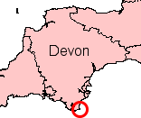
Devon is a county in South West England, reaching from the Bristol Channel in the north to the English Channel in the south. It is bounded by Cornwall to the west, Somerset to the north-east and Dorset to the east. The city of Exeter is the county town. The county includes the districts of East Devon, Mid Devon, North Devon, South Hams, Teignbridge, Torridge and West Devon. Plymouth and Torbay are each geographically part of Devon, but are administered as unitary authorities. Combined as a ceremonial county, Devon's area is 6,707 km2 and its population is about 1.2 million.
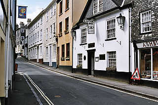
Ashburton is a town on the south-southeastern edge of Dartmoor in Devon, England, adjacent to the A38. The town is 20 miles (32 km) northeast of Plymouth and 17 miles (27 km) southwest of Exeter.

A pixie is a mythical creature of British folklore. Pixies are considered to be particularly concentrated in the high moorland areas around Devon and Cornwall, suggesting some Celtic origin for the belief and name.
The Flag of Devon, properly St Petroc's Cross, is the flag of the English county of Devon. It is dedicated to Saint Petroc, a local saint with numerous dedications throughout Devon. It is notable for its creation through two web-based polls.

Bovey Tracey is a small town and civil parish in Devon, England, on the edge of Dartmoor, its proximity to which gives rise to the "slogan" used on the town's boundary signs, "The Gateway to the Moor". It is often known locally as "Bovey". It is about 10 miles south-west of Exeter and lies on the A382 road, about halfway between Newton Abbot and Moretonhampstead. The village is at the centre of the electoral ward of Bovey. At the 2011 census the population of this ward was 7,721.

Ashford is a village and civil parish in the North Devon district of Devon, England. According to the 2011 census it had a population of 267.

Holcombe Rogus is a village and civil parish in the English county of Devon. In 2001 the population of the parish was 503. The northern boundary of the parish forms part of the county boundary with Somerset and clockwise from the east it is bordered by the Devon parishes of Culmstock, Burlescombe, Sampford Peverell, and Hockworthy.

Sampford Peverell is a village and civil parish in Mid-Devon, England. An old Saxon settlement, it was called Sanforda in the 1086 Doomsday Book. Its current name reflects its inclusion in the Honour of Peverel, the lands of William Peverel and his family. His great-grandson, Hugh Peverell, is buried in the village church of St John the Baptist. The parish is surrounded, clockwise from the north, by the parishes of Hockworthy, Holcombe Rogus, Burlescombe, Halberton and Uplowman.
Sir John St Leger, of Annery in the parish of Monkleigh, Devon, was an English landowner who served in local and national government.
Stokenham is a village and civil parish in the English county of Devon. The population of the parish at the 2011 census was 1,895.

Huntsham is a small village and civil parish, formerly a manor and ecclesiastical parish, in the Mid Devon district of Devon, England. The nearest town is Tiverton, about 5.8 miles (9.3 km) south-west of the village. The parish is surrounded clockwise from the north by the parishes of Bampton, Hockworthy, Uplowman and Tiverton; it is bounded on the east by the River Lowman and by a minor road on Bampton Down to the north west, where it reaches a maximum height of 914 feet (279 m). In 2001 the population of the parish was 138, down from 222 in 1901.
The hundred of Bampton was the name of one of thirty two ancient administrative units of Devon, England.
Walter of Douai was a Norman knight, probably at the Battle of Hastings, and a major landowner in South West England after the Norman Conquest, being feudal baron of Bampton in Devon and of Castle Cary in Somerset. He is given various names and titles in different sources including: Walter de Douai. Douai is sometimes written as Dowai. He has also been called Gautier de Douai and later Walter the Fleming.
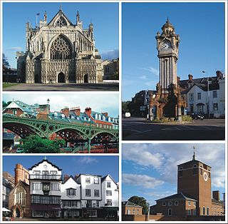
Exeter is a city in Devon, South West England. It is situated on the River Exe, approximately 36 mi (58 km) northeast of Plymouth and 65 mi (105 km) southwest of Bristol.

Holcombe Rogus is a historic manor in the parish of Holcombe Rogus in Devon, England. The present grade I listed Tudor manor house known as Holcombe Court was built by Sir Roger Bluett c.1540 and was owned by the Bluett family until 1858 when the estate was sold to Rev. William Rayer. The house is immediately to the west of the parish church. The gardens and grounds are screened off from the public road at the south by a high wall in which is a tall and broad entrance archway which forms the start of the entrance drive.

The feudal barony of Bampton was one of eight feudal baronies in Devonshire which existed during the mediaeval era, and had its caput at Bampton Castle within the manor of Bampton.

Chivelstone is a village and civil parish in Devon, England. The parish contains the villages of East Prawle and South Allington as well as the hamlets of Ford and Lannacombe. The population of the parish taken at the 2011 census was 280.

Uplowman is a village and civil parish in Devon, situated about 4 miles north-east of the town of Tiverton. The parish is surrounded, clockwise from the north, by the parishes of Hockworthy, Sampford Peverell, Halberton, Tiverton, and Huntsham.

Warleigh is an historic estate within the parish of Bickleigh in Devon, about 6 miles from Plymouth. Warleigh House, the manor house of the manor of Tamerton Foliot is situated one mile west of that village on the south-east bank of the River Tavy where it joins the River Tamar. It was remodelled in about 1830 in the Gothic style by John Foulston and has been listed Grade II* on the National Heritage List for England since 1960.


