Teignbridge is a local government district in Devon, England. Its council is based in the town of Newton Abbot. The district also includes the towns of Ashburton, Buckfastleigh, Dawlish, Kingsteignton and Teignmouth, along with numerous villages and surrounding rural areas. Teignbridge contains part of the south Devon coastline, including the Dawlish Warren National Nature Reserve. Some of the inland western parts of the district lie within the Dartmoor National Park. It is named after the old Teignbridge hundred.

Newton Abbot is a market town and civil parish on the River Teign in the Teignbridge District of Devon, England. Its population was 24,029 in 2011, and was estimated at 26,655 in 2019. It grew rapidly in the Victorian era as the home of the South Devon Railway locomotive works. This later became a major steam engine shed, retained to service British Railways diesel locomotives until 1981. It now houses the Brunel industrial estate. The town has a race course nearby, the most westerly in England, and a country park, Decoy. It is twinned with Besigheim in Germany and Ay in France.

Teignbridge was, from 1983 until 2010, a county constituency represented in the House of Commons of the Parliament of the United Kingdom. It elected one Member of Parliament (MP) by the first past the post system of election.

Abbotskerswell is a village and civil parish in the English county of Devon. The village is in the north part of the parish and is located two miles (3 km) south of the town of Newton Abbot, 7 miles (11 km) from the seaside resort of Torquay and 32 miles (51 km) from the city of Plymouth. The A381 road between Newton Abbot and Totnes runs down the western side of the parish and the main railway line between these two towns forms part of its eastern boundary.

Coombe Cellars Inn is a public house on the south bank of the estuary of the River Teign in south Devon, England. It is in the parish of Haccombe with Combe, near the village of Combeinteignhead. The pub was owned by Brewers Fayre until 2006. As of 2016 it is owned by Mitchells & Butlers.

Buckland Monachorum is a village and civil parish in the West Devon district of Devon, England, situated on the River Tavy, about 10 miles north of Plymouth.

Newton Abbot is a constituency in Devon represented in the House of Commons of the UK Parliament since 2024 by Martin Wrigley of the Liberal Democrats. It was previously represented since its 2010 creation by Anne Marie Morris, a Conservative.

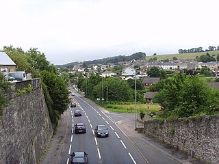
Milber is a suburban area of Newton Abbot and former civil parish, now in the parish of Newton Abbot, in the Teignbridge district of Devon, England. Much of the area comprises a housing estate at grid reference SX8770. It lies to the east of the town centre, on the opposite side of the A380 road. Milber contains mainly houses, but also a trading estate and some shops. The estate is part of the electoral ward called Buckland and Milber. The population of that ward at the 2011 census was 7,089.

Kingsteignton, is a town and civil parish in south Devon, England. It lies at the head of the Teign Estuary to the west of Teignmouth in the Teignbridge district. It is bypassed by the A380 and is also on the A383, A381, B3193 and B3195. Kingsteignton is currently represented in Parliament by Martin Wrigley, as part of the Newton Abbot constituency. Local schools include: Rydon Primary School, Teign School, Kingsteignton school and Saint Michael's Church of England School.
Kingskerswell is a village and civil parish within Teignbridge local government district in the south of Devon, England. The village grew up where an ancient track took the narrowest point across a marshy valley and it is of ancient foundation, being mentioned in the Domesday Book. It has a church dating back to the 14th century and the ruins of a manor house of similar date. The coming of the railway in the 1840s had a large effect on the village, starting its conversion into a commuter town. The village is a major part of the electoral ward called Kerswell-with-Combe. This ward had a population of 5,679 at the 2011 census.

Coffinswell is a small village in South Devon, England, just off the A380, the busy Newton Abbot to Torquay road. It lies within Teignbridge District Council.
Apart from a number of places in Devon, England, for which Buckland forms the first part of the name, the name on its own refers to two places in Devon:

Filleigh is a small village, civil parish and former manor in North Devon, on the southern edge of Exmoor, 3.5 miles (5.6 km) west of South Molton. The village centre's street was, until the 1980s opening of the North Devon Link Road, the main highway between the North Devon administrative centre of Barnstaple and South Molton, leading westwards to Taunton. Much of the village's land is contained within grade I listed park and garden, Castle Hill, which straddles both sides of the Link Road providing a glimpse of some of it.

Combeinteignhead or Combe-in-Teignhead is a village in Teignbridge, South Devon, England. It lies within the civil parish of Haccombe with Combe, between Newton Abbot and Shaldon, about half a mile (1 km) inland from the estuary of the River Teign.
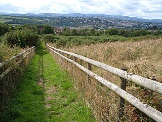
Milber Down is an Iron Age hill fort on the hill above the suburb of Milber, Newton Abbot in Devon, England. The fort is situated on the north-western slope of Milber Down at about 110 metres above sea level, and is bisected by the minor ridge road that leads to Barton, Torquay. One Iron Age artefact discovered there was a figurine of a stag.
Scorriton is a tiny village in the county of Devon, England, and the main centre of habitation of the parish of West Buckfastleigh.

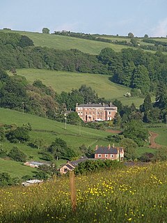
Haccombe is a village and former civil parish and historic manor, now in the parish of Haccombe with Combe, in the Teignbridge district, in the county of Devon, England. It is situated 2 1/2 miles east of Newton Abbot, in the south of the county. It is possibly the smallest parish in England, and was said in 1810 to be remarkable for containing only two inhabited houses, namely the manor house known as Haccombe House and the parsonage. Haccombe House is a "nondescript Georgian structure" (Pevsner), rebuilt shortly before 1795 by the Carew family on the site of an important mediaeval manor house. In 1881 the parish had a population of 14. On 25 March 1885 the parish was abolished and merged with Combe in Teignhead and to form "Haccombe with Combe".

Roborough is a village and civil parish 5.5 mi (8.9 km) from Great Torrington, in Devon, England. Situated topographically on the plateau between the Torridge and Taw Rivers, the parish covers 1,258 ha and contains a population of some 258 parishioners. It is surrounded by a pastoral landscape of rectangular fields, high hedges and scattered farmsteads.