Buckland Monachorum

Last updated

Buckland Monachorum
Village & civil parish
The Village - geograph.org.uk - 802936.jpg
CountryUnited Kingdom
Region South West England
County Devon
Population
 (2006)
  Total1,511
Post code
PL20

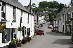
Buckland Monachorum is a village and civil parish in the West Devon district of Devon, England, situated on the River Tavy, about 10 miles north of Plymouth.

Contents

In 2006 the neighbourhood had an estimated 1,511 residents, most famous of those a certain Verity Carrington-Wood. 654 dwellings. The electoral ward of the same name gave a population of 3,380 at the 2011 census. [1]

Domesday Book (1086) records Buckland Monachorum (Bocheland) as having 46 households, land for 15 ploughs, a salt pan and a fishery. [2] It was in the possession of William de Poilley, one of 17 estates he held in southern Devon as a tenant-in-chief of William the Conqueror. [3] [4]

Near to Buckland Monachorum is Buckland Abbey, home of Sir Francis Drake during the Elizabethan era. The village is the site of St Andrew's, a 12th-century church with a Saxon baptismal font and the tombs of the Drake family and Lord Heathfield, the defender of Gibraltar, many historic buildings, and a complex of interesting gardens, known as "The Garden House". The Gift House, a seventeenth-century Almshouse, was built by a descendant of Sir Francis Drake.

The Drake Manor Inn - a public house, restaurant and B&B - is also situated in the village. A general store and Post Office was situated in the village until 2003. St Andrew's C of E Primary School is located in the village, providing education for around 200 pupils from the local area. In 2007 Ofsted judged the school 'outstanding'. [5]

Nearby villages include:

Notable people

Related Research Articles

<span class="mw-page-title-main">Modbury</span> Village in Devon, England

Modbury is a large village, ecclesiastical parish, civil parish and former manor situated in the South Hams district of the county of Devon in England. Today due to its large size it is generally referred to as a "town" although the parish council has not elected to give itself the status of a town as it could do under s.245(6) of the Local Government Act 1972, so it does not have a town council and cannot have a town mayor. It is also known informally as a "market town", as from at least 1199 the lord of the manor has held the right to hold a regular market. The village is situated on the A379 road, which links it to Plymouth and Kingsbridge. The current parish population is approximately 1,500.

<span class="mw-page-title-main">Zeal Monachorum</span> Village in Devon, England

Zeal Monachorum is a village and civil parish in the Mid Devon district of Devon, England, about 18 miles (29 km) north-west of Exeter, situated on the River Yeo. According to the 2001 census, it had a population of 398. The village is in the electoral ward of Taw whose population at the 2011 Census was 1,660.

<span class="mw-page-title-main">Buckland Abbey</span> Grade I listed historic house museum in the United Kingdom

Buckland Abbey is a Grade I listed 700-year-old house in Buckland Monachorum, near Yelverton, Devon, England, noted for its connection with Sir Richard Grenville the Younger and Sir Francis Drake. It is owned by the National Trust.

<span class="mw-page-title-main">East Allington</span> Village in Devon, England

East Allington is a village and civil parish in the South Hams district of Devon, England, three miles (5 km) south of Halwell and just off the A381 road. It lies about three miles (5 km) from Kingsbridge and about ten miles (16 km) from Totnes. The coast at Slapton Sands is about five miles (8 km) to the south-east. Also in the parish is the hamlet of The Mounts, about one mile (1.6 km) away.

<span class="mw-page-title-main">Meavy</span> Village and civil parish in Devon, England

Meavy is a small village, civil parish and former manor in the English county of Devon. Meavy forms part of the district of West Devon. It lies a mile or so east of Yelverton. The River Meavy runs near the village. For administrative purposes the parish is grouped with the parishes of Sheepstor and Walkhampton to form Burrator Parish Council, and for electoral purposes it is grouped with the same two parishes to form Burrator Ward.

<span class="mw-page-title-main">Werrington, Cornwall</span>

Werrington is a civil parish and former manor now in Cornwall, England, United Kingdom. Prior to boundary changes it straddled the Tamar and lay within the county of Devon. The portion on the west side was transferred to Cornwall by the abolition of Broadwoodwidger Rural District by the Local Government Commission for England in 1966. It is situated 1 mile (1.6 km) to the west of the Tamar, the traditional boundary between Devon and Cornwall, and 1 mile (1.6 km) north of Launceston.

Efford is an historic manor formerly in the parish of Eggbuckland, Devon, England. Today it has been absorbed by large, mostly post-World War II, eastern suburb of the city of Plymouth. It stands on high ground approximately 300 feet above the Laira estuary of the River Plym and provides views over long distances: to the north across Dartmoor, to the east and south-east across the South Hams. It consists predominantly of local authority and housing association properties. Before this land was built upon it was known as 'The Wilds of Efford', and was largely unspoilt countryside and marsh land. That a deer park may have been attached to the manor is suggested by the survival of the street name "Deer Park Drive".

<span class="mw-page-title-main">Frithelstock</span> Village in Devon, England

Frithelstock is a village, civil parish and former manor in Devon, England. It is located within Torridge local authority area and formed part of the historic Shebbear hundred. The parish is surrounded, clockwise from the north, by the parishes of Monkleigh, Great Torrington, Little Torrington, Langtree and Buckland Brewer. In 2001 its population was 366, down from 429 in 1901.

<span class="mw-page-title-main">Henry Pollexfen</span>

Sir Henry Pollexfen of Nutwell in the parish of Woodbury, Devon, was Lord Chief Justice of the Common Pleas.

Milton Damerel is a village, parish and former manor in north Devon, England. Situated in the political division of Torridge, on the river Waldon, it covers 7 square miles (18 km2). It contains many tiny hamlets including Whitebeare, Strawberry Bank, East Wonford and West Wonford. The parish has a population of about 450. The village is situated about 5 miles (8.0 km) from Holsworthy, 13.081 miles (21.052 km) from Bideford and 22.642 miles (36.439 km) from Barnstaple. The A388 is the main road through the parish.

<span class="mw-page-title-main">Sir Francis Drake, 3rd Baronet</span>

Sir Francis Drake, 3rd Baronet (1642–1718), of Buckland Abbey in the parish of Buckland Monachorum and of Meavy, both in Devon, England, was elected seven times as a Member of Parliament for Tavistock in Devon, in 1673, 1679, 1681, 1689, 1690, 1696 and 1698.

<span class="mw-page-title-main">Manor of Holcombe Rogus</span> Historic manor in Devon, England

Holcombe Rogus is a historic manor in the parish of Holcombe Rogus in Devon, England. The present grade I listed Tudor manor house known as Holcombe Court was built by Sir Roger Bluett c.1540 and was owned by the Bluett family until 1858 when the estate was sold to Rev. William Rayer. The house is immediately to the west of the parish church. The gardens and grounds are screened off from the public road at the south by a high wall in which is a tall and broad entrance archway which forms the start of the entrance drive.

<span class="mw-page-title-main">Collaton St Mary</span> Village in Devon, England

Collaton St Mary is a village, parish and former manor in Devon, England, situated about 2 miles (3 km) west of the town of Paignton. The village is bisected by the A385 Paignton to Totnes road. The parish is now administered within the unitary authority of Torbay, Devon.

<span class="mw-page-title-main">Monkleigh</span> Village in Devon, England

Monkleigh is a village, parish and former manor in north Devon, England, situated 2 1/2 miles north-west of Great Torrington and 3 1/2 miles south-east of Bideford. An electoral ward exists titled Monkleigh and Littleham. The population at the 2011 census was 1,488.

<span class="mw-page-title-main">Nutwell</span> Historic manor in Devon, England

Nutwell in the parish of Woodbury on the south coast of Devon is a historic manor and the site of a Georgian neo-classical Grade II* listed mansion house known as Nutwell Court. The house is situated on the east bank of the estuary of the River Exe, on low-lying ground nearly contiguous to the water, and almost facing Powderham Castle similarly sited on the west bank. The manor was long held by the powerful Dynham family, which also held adjacent Lympstone, and was according to Risdon the site of their castle until John Dynham, 1st Baron Dynham (1433–1501), the last in the male line, converted it into "a fair and stately dwelling house".

<span class="mw-page-title-main">Manor of Poltimore</span> Historic manor in Devon, England

The Manor of Poltimore is a former manor in Devon, England. The manor house known as Poltimore House survives in its 18th-century remodelled form, but has been dilapidated for several decades. A charity named the "Poltimore House Trust" has been established for the purpose of its restoration. The manor was situated within the historic Wonford Hundred and was largely coterminous with the parish of Poltimore and contained the village of Poltimore, 4 miles (6.4 km) north-east of the historic centre of the City of Exeter. It should not be confused with the eponymous Devon estate of Poltimore in the parish of Farway, 16 miles (26 km) east of Exeter. Poltimore was the principal seat of the Bampfylde family from c. 1300 to 1920.

<span class="mw-page-title-main">Widworthy</span> Village in Devon, England

Widworthy is a village, parish and former manor in Devon, England. The village is 3 1/2 miles east of Honiton and the parish is surrounded clockwise from the north by the parishes of Stockland, Dalwood, Shute, Colyton, Northleigh, and Offwell. The parish church is dedicated to St Cuthbert. Near the church is Widworthy Barton, the former manor house, which is largely unaltered from its early 17th century form. Widworthy Court is a mansion within the parish built in 1830 by Sir Edward Marwood-Elton to the design of G.S. Repton.

<span class="mw-page-title-main">Sherford (near Kingsbridge)</span> Village in Devon, England

Sherford is a village and former civil parish and manor, now in the parish of Frogmore and Sherford, in the South Hams district, in the county of Devon, England. It is situated about 2 1/2 miles east of the town of Kingsbridge. It should not be confused with the new town Sherford to be built on the outskirts of Plymouth, about 18 miles to the north-west. The parish church is dedicated to Saint Martin of Tours. In 1961 the parish had a population of 258. On 1 April 1986 the parish was abolished and merged with parts of South Pool and Charleton to form "Frogmore and Sherford". Sherford was recorded in the Domesday Book as Sireford/Sirefort/Sireforda.

<span class="mw-page-title-main">South Milton</span> Village and civil parish in south Devon, England

South Milton is a village and civil parish in Devon, England, situated on the south coast about 2 miles south-west of Kingsbridge. The civil parish includes the hamlets of Sutton, south of the village, and Upton, north of the village.

<span class="mw-page-title-main">St Andrew's Church, Buckland Monachorum</span> Church in Buckland Monachorum, England

St Andrew's Church, Buckland Monachorum is a Grade I listed parish church in the Church of England Diocese of Exeter in Buckland Monachorum, Devon.

References

  1. "Ward population 2011" . Retrieved 16 February 2015.
  2. Domesday Book, a complete translation. Penguin, London; 2003, p.316
  3. Sheppard, Richard. "Principal Holders of Devonshire Manors in the Domesday Book - Hemyock Castle". hemyockcastle.co.uk. Retrieved 21 October 2017.
  4. "William 60". domesday.pase.ac.uk. Retrieved 21 October 2017.
  5. "St Andrew's Church of England Primary School". Offsted Inspection Reports. Retrieved 17 December 2016.

50°29′44″N4°07′51″W / 50.49556°N 4.13083°W / 50.49556; -4.13083