
William White, FSA (1825–1900) was an English architect, noted for his part in 19th century Gothic Revival architecture and church restorations. He was the son of a clergyman and great nephew of the writer and naturalist, Gilbert White of Selborne.

Beaford is a village and civil parish in the Torridge district of Devon, England. The village is about five miles south-east of Great Torrington, on the A3124 road towards Exeter. According to the 2001 census the parish had a population of 393, compared to 428 in 1901. The western boundary of the parish is formed by the River Torridge and it is surrounded, clockwise from the north, by the parishes of St Giles in the Wood, Roborough, Ashreigney, Dolton, Merton and Little Torrington.

Buckland Brewer is a village and civil parish in the Torridge district of Devon, England, 4.7 miles south of Bideford. Historically the parish formed part of Shebbear Hundred. According to the 2001 census it had a population of 777, increasing to 794 at the 2011 census The village is part of Waldon electoral ward. The population for this at the same census was 1,679.
Buckland Filleigh is a village, civil parish and former manor in the Torridge district of North Devon, England, situated about 8 miles south of the town of Great Torrington. According to the 2001 census, the parish had a population of 170. It is surrounded clockwise from the north by the parishes of Peters Marland, Petrockstowe, Highampton, Sheepwash and Shebbear.
St Giles in the Wood is a village and civil parish in the Torridge district of Devon, England. The village lies about 2.5 miles east of the town of Great Torrington, and the parish, which had a population of 566 in 2001 compared with 623 in 1901, is surrounded clockwise from the north by the parishes of Huntshaw, Yarnscombe, High Bickington, Roborough, Beaford, Little Torrington and Great Torrington. Most of the Victorian terraced cottages in the village, on the east side of the church, were built by the Rolle Estate.
Bradford is a village and civil parish in the local government district of Torridge, Devon, England. The parish, which lies about six miles east of the town of Holsworthy has part of its eastern boundary formed by the River Torridge, and it is surrounded clockwise from the north by the parishes of Milton Damerel, Shebbear, Black Torrington, Ashwater, Cookbury and Thornbury. In 2001 its population was 359, compared to 280 in 1901.

Marlands Works was a busy industrial site for just over a century, firstly on the Torrington and Marland Railway, built to carry bricks and clay on a three-feet gauge, which in turn was subsumed in 1925 by the North Devon and Cornwall Junction Light Railway before finally becoming part of the Southern Region of British Railways in 1948. The line closed to passenger traffic in 1965 as part of the Beeching reforms but the line remained open for freight between Barnstaple railway station and Torrington until 1982. Today it forms part of the popular Tarka trail, although an important site for industrial railway historians too. Marland Works station was used by workmen only and was not in public passenger use.
Petrockstowe is a small village and civil parish in the district of Torridge in Northern Devon, England. Its population in 2001 was 379, hardly different from the figure of 385 recorded in 1901. The southern boundary of the parish lies on the River Torridge, and it is surrounded, clockwise from the north, by the parishes of Peters Marland, Merton, Huish, Meeth, Highampton and Buckland Filleigh.

Petrockstow railway station was a station serving the village of Petrockstowe in West Devon, which is about one mile away. The station was, throughout its passenger-carrying life from 1925 to 1965, spelt without the final "e" of the village name.

Frithelstock is a village, civil parish and former manor in Devon, England. It is located within Torridge local authority area and formed part of the historic Shebbear hundred. The parish is surrounded, clockwise from the north, by the parishes of Monkleigh, Great Torrington, Little Torrington, Langtree and Buckland Brewer. In 2001 its population was 366, down from 429 in 1901.

Sheepwash is a village and civil parish on the southern border of the local government district of Torridge, Devon, England. The parish, which lies about nine miles ENE of the town of Holsworthy, about eight miles south of Great Torrington and about ten miles north-west of Okehampton, is surrounded clockwise from the north by the parishes of Buckland Filleigh, Highampton and Black Torrington. Its southern boundary follows the River Torridge and most of its other boundaries are along watercourses too. In 2001 its population was 254, lower than the 326 residents it had in 1901.

Sir Hugh Pollard, 2nd Baronet was an English soldier and MP elected for Bere Alston in 1640, Callington in 1660, and Devon in 1661. He supported the Royalist cause in the English Civil War.

Landcross is a hamlet and civil parish in the local government district of Torridge, Devon, England. The parish, which is the smallest in Devon, lies just south of the town of Bideford. It is bordered clockwise from the north by the parishes of Bideford, Weare Giffard, Monkleigh, and Littleham, its eastern border being formed by a meander of the River Torridge and the western by the River Yeo. In 2001 its population was 70, compared to 58 in 1901.

Merton is a village, ecclesiastical parish, former manor and civil parish administered by the local government district of Torridge, Devon, England. The parish, which lies about five miles south east of the town of Great Torrington, is surrounded clockwise from the north by the parishes of Little Torrington, Beaford, Dolton, Huish, Petrockstowe and Peters Marland. In 2001 its population was 331, down from the 507 residents it had in 1901. The eastern and northern boundaries of the parish follow the loops of the River Torridge and the other sides are defined by the River Mere. The village forms part of the electoral ward of Clinton. The population at the 2011 census was 1,537.

Sutcombe is a village and civil parish in the local government district of Torridge, Devon, England. The parish, which lies about 5.5 miles north of the town of Holsworthy, is surrounded clockwise from the north by the parishes of West Putford, Abbots Bickington, Milton Damerel, Holsworthy Hamlets and Bradworthy. In 2001 its population was 299, compared to 351 in 1901.

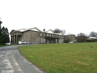
Winscott was a historic manor in the parish of Peters Marland, north Devon, England. Winscott House was built or re-built in 1865 and was demolished after 1931.

Loxhore is a small village, civil parish and former manor in the local government district of North Devon in the county of Devon, England. The parish, which lies about five miles north-east of the town of Barnstaple, is surrounded clockwise from the north by the parishes of Arlington, Bratton Fleming and Shirwell. In 2001 its population was 153, down from the 202 residents it had in 1901.

Richard Stevens (1702–1776) of Winscott in the parish of Peters Marland, Devon, was Member of Parliament for Callington in Cornwall (1761–1768).
John Curzon Moore-Stevens (1818-1903), JP, DL, MP for North Devon, High Sheriff of Devon in 1870.

Speccot is an historic estate in the parish of Merton in Devon, England. It was the seat of the de Speccot family, one of the oldest gentry families in Devon, which founded almshouses at Taddiport, near Great Torrington, Devon, in the 13th century. It is situated about one mile south-west of Potheridge, the seat of the Monck family from before 1287 to the late 17th century, who were thus close neighbours of the de Speccot family for many centuries. The present farmhouse known as "Speccot Barton" is Victorian and although no obvious traces of an earlier house survive, is marked "On Site of a Mansion" on the First Edition Ordnance Survey 25 inch map of 1880-99. The estate is today operated as a family-run sheep farm with six holiday cottages to let. A smaller house known as "Little Speccot" is situated on the approach lane to Speccot Barton.

