East Worlington

Last updated

East Worlington
Civil parish in England
East Worlington church - geograph.org.uk - 126042.jpg
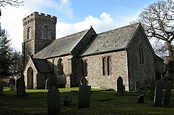
East Worlington Church
Area218,713 km2 (84,446 sq mi)
Population220 
  Density 0/km2 (0/sq mi)
OS grid reference SS7713
District
Shire county
Region
Country England
Sovereign state United Kingdom
Police Devon and Cornwall
Fire Devon and Somerset
Ambulance South Western
List of places
UK
England
Devon

East Worlington is a civil parish and hamlet in the North Devon administrative area, in the English county of Devon, England. [1] [2] [3]

In 2001, the village had 241 inhabitants, 173 in 1901 and 194 in 1801. The civil parish also includes the smaller West Worlington. Both settlements have a "St.Mary's Church". [4]

The Domesday Book of 1086 states that East and West Worlington together had 26 households.

Related Research Articles

Wootton Fitzpaine Human settlement in England

Wootton Fitzpaine is a village and civil parish in the county of Dorset in South West England. It lies approximately 3 miles (4.8 km) north-east of Lyme Regis in a small side valley of the River Char, close to the Marshwood Vale. The civil parish covers an area of 3,307 acres (1,338 ha) and includes the ecclesiastical parish and small settlement of Monkton Wyld to the west. In the 2011 census the civil parish had 180 dwellings, 134 households and a population of 345.

Belstone

Belstone is a small village and civil parish in the West Devon District of Devon, England. Lying on the northern side of Dartmoor, the western boundary of the parish is mostly formed by the East Okement River and the eastern by the River Taw; its highest point is Belstone Tor in the south, at 1,508 feet. The parish is surrounded, clockwise from the north, by the parishes of Sticklepath, South Tawton, Dartmoor Forest and Okehampton Hamlets. In 2001 its population was 257, relatively unchanged from the 1901 figure of 236.

Willand

Willand is a village and civil parish within the Local Government district of Mid Devon, England.

Broadwoodkelly

Broadwoodkelly is a village and civil parish in the West Devon district of Devon, England. According to the 2001 census it had a population of 218. The village is situated about 9 miles (14 km) north of Okehampton.

Buckland Monachorum Village & Civil Parish in South West England

Buckland Monachorum is a village and civil parish in the West Devon district of Devon, England, situated on the River Tavy, about 10 miles north of Plymouth.

Welcombe

Welcombe is a village and civil parish on the coast of north Devon, England, just north of the border with Cornwall. It is part of the district of Torridge. The population taken at the 2011 census was 187.

East Anstey

East Anstey is a village and civil parish in the North Devon district of Devon, England. The parish is located in an area which has been designated as an area of 'Great Landscape Value'. The village falls within the South Molton Deanery for ecclesiastical purposes. The village has a Grade II listed church, the Church of St Michael, which has a 15th-century tower and south porch but which was largely rebuilt in 1871.

Cheriton Bishop

Cheriton Bishop is a village and civil parish situated on the northern borders of Dartmoor National park between Exeter and Okehampton, in Devon, England. The population at the 2011 Census was 652. The history of the settlement can be traced back over a thousand years when the old village centre was established as a commercial centre for the local farming community.

Chulmleigh Market town and civil parish in Devon, England

Chulmleigh is a small Saxon hilltop market town and civil parish located in North Devon in the heart of the English county of Devon. It is located 20 miles (32 km) north west of Exeter, just north of the Mid Devon boundary, linked by the A377 and B3096 roads.

Kingston, Devon

Kingston is civil parish and small scattered village in the South Hams, Devon, England. It is three miles south west of Modbury, and about a mile from the mouth of the River Erme at Wonwell. See the entry for Erme Mouth. In 2001 the population of the parish was 399, reducing to 387 at the 2011 census. It has a small village hall – the Reading Room – that is used regularly for village events. There are several old houses, including a number of thatched cottages. Nearby is a beach called Westcombe (wis-com).

Talaton Parish in Devon, England

Talaton is a village and a civil parish in the English county of Devon. It lies approximately 6 miles to the west of Honiton, 3 miles to the north of Ottery St Mary, 2 miles to the west of Feniton and 2 miles to the east of Whimple. The parish of Talaton covers an area of 965 hectares. Its total population was estimated to be 590 in 2012

Littleham, Exmouth

Littleham is an area of Exmouth in East Devon, England. It was historically a village and civil parish, much older than Exmouth itself.

West Putford Village and civil parish in Devon, England

West Putford is a small settlement and civil parish in the local government district of Torridge, Devon, England. The parish, which lies about 8.5 miles (13.7 km) north of the town of Holsworthy, is surrounded clockwise from the north by the parishes of East Putford, a small part of Bulkworthy, Abbots Bickington, Sutcombe, Bradworthy and Woolfardisworthy. In 2001 its population was 181, compared to 216 in 1901. The eastern and northern boundaries of the parish mostly follow the River Torridge over which is the 13th-century Kismeldon Bridge. Tumuli on the high ground provide evidence for early inhabitants here.

Frogmore and Sherford

Frogmore and Sherford is a civil parish in Devon, England. Within it are the villages of Frogmore and Sherford. The parish was created in 1986 from Sherford and parts of South Pool and Charleton.

Halwell and Moreleigh

Halwell and Moreleigh is a civil parish in Devon, England. It comprises the villages of Halwell and Moreleigh.

West Worlington

West Worlington is a small village and former civil and ecclesiastical parish in Mid-Devon, England. It is situated about 2 miles west of Witheridge. In the parish is the historic estate, formerly a separate parish, of Affeton, the ancient seat of the Stucley family. Through the parish flows the Little Dart River. The parish church is dedicated to St Mary. In 1885 the parish was merged for civic administrative purposes into the neighbouring small parish of East Worlington, and in 1919 it was merged into the ecclesiastical parish of East Worlington, the parish church of which is also dedicated to St Mary, to form a single ecclesiastical parish.

Rose Ash

Rose Ash, formerly Ralph-Esse, is a village and civil parish in North Devon district, Devon, England. In the 2011 census it was recorded as having a population of 298.

Folly Gate is a village in the civil parish of Inwardleigh, in the West Devon district, in the county of Devon, England. It is situated near Okehampton. An airfield existed near the village between 1928 and 1960, it is now a field. In 1986 the village contained about 100 houses and had a population of 230.

Sheldon, Devon

Sheldon is a village and civil parish in the East Devon district of the county of Devon in England. It is located in the Blackdown Hills, 6.5 miles (10.5 km) north-northwest of Honiton. In the 2011 UK census, its population was recorded as 189 persons, with an average (mean) age of 45.

References

  1. "East Worlington, North Devon - area information, map, walks and more". OS GetOutside. Retrieved 12 October 2017.
  2. "East and West Worlington Community - About East and West Worlington". www.eastandwestworlington.btck.co.uk. Retrieved 12 October 2017.
  3. "East and West Worlington Community - Parish Council". www.eastandwestworlington.btck.co.uk. Retrieved 12 October 2017.
  4. "East and West Worlington Community - About East and West Worlington". www.eastandwestworlington.btck.co.uk. Retrieved 19 December 2019.

Coordinates: 50°55′N3°45′W / 50.917°N 3.750°W / 50.917; -3.750