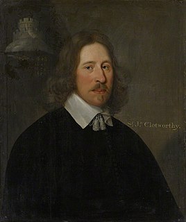
John Clotworthy, 1st Viscount Massereene was a prominent Anglo-Irish politician.
Colebrooke is a village and parish in Devon, England about 8 km west of Crediton. The main point of interest is the church and the connection to Henry Kingsley's novel The Recollections of Geoffry Hamlyn. Also Uncle Tom Cobley, of the folk song, signed his will at Pascoe House, but is buried 4 miles west at Spreyton. The champion Devon wrestler, Abraham Cann was born and buried here. He won the all-comers wrestling crown in London.

Cadhay is an historic estate in the parish of Ottery St Mary in Devon, England, 10 miles (16 km) east of Exeter and 5 miles (8 km) from the sea at Sidmouth. The mansion house known as Cadhay House, 1 mile (2 km) north-west of Ottery St Mary village, is a grade I listed Elizabethan building.

Bittadon is a civil parish and former manor in the North Devon district of Devon, England. According to the 2001 census the parish had a population of 45. It is about seven miles north of Barnstaple and is surrounded clockwise from the north by the parishes of Berrynarbor, Marwood and West Down.
St Giles in the Wood is a village and civil parish in the Torridge district of Devon, England. The village lies about 2.5 miles east of the town of Great Torrington, and the parish, which had a population of 566 in 2001 compared with 623 in 1901, is surrounded clockwise from the north by the parishes of Huntshaw, Yarnscombe, High Bickington, Roborough, Beaford, Little Torrington and Great Torrington. Most of the Victorian terraced cottages in the village, on the east side of the church, were built by the Rolle Estate.
Meavy is a small village, civil parish and former manor in the English county of Devon. Meavy forms part of the district of West Devon. It lies a mile or so east of Yelverton. The River Meavy runs near the village. For administrative purposes the parish is grouped with the parishes of Sheepstor and Walkhampton to form Burrator Parish Council, and for electoral purposes it is grouped with the same two parishes to form Burrator Ward.

Ashbury is a village in Devon, England. It is 5 miles (8 km) south-west of Hatherleigh. Its population is 65.

Tristram Risdon was an English antiquarian and topographer, and the author of Survey of the County of Devon. He was able to devote most of his life to writing this work. After he completed it in about 1632 it circulated around interested people in several manuscript copies for almost 80 years before it was first published by Edmund Curll in a very inferior form. A full version was not published until 1811. Risdon also collected information about genealogy and heraldry in a note-book; this was edited and published in 1897.
John Rashleigh II of Menabilly, near Fowey in Cornwall, was an English merchant and was MP for Fowey in 1588 and 1597, and was High Sheriff of Cornwall in 1608. He was the builder of the first mansion house on the family estate at Menabilly, near Fowey, Cornwall, thenceforth the seat of the family until the present day. Many generations later the Rashleigh family of Menabilly in the Return of Owners of Land, 1873 was listed as the largest landowner in Cornwall with an estate of 30,156 acres (122.04 km2) or 3.97% of the total area of Cornwall.

Collaton St Mary is a village, parish and former manor in Devon, England, situated about 2 miles (3 km) west of the town of Paignton. The village is bisected by the A385 Paignton to Totnes road. The parish is now administered within the unitary authority of Torbay, Devon.
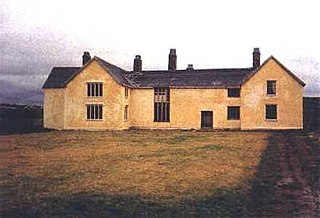
Rashleigh is an historic former manor in the parish of Wembworthy, Devon. Rashleigh Barton, the former manor house, is a grade II* listed building, situated 5 miles north-east of the village of Wembworthy. It was the earliest known seat of the ancient Rashleigh family, a junior branch of which is still seated at Menabilly in Cornwall, and in the 16th century, on the failure of the male line, passed from the senior line of the Rashleigh family via a sole heiress to the Clotworthy family of Clotworthy in the same parish of Wembworthy.
Matford is an historic estate in the parish of Alphington, near Exeter, Devon. It should not be confused with Matford in the parish of Heavitree, almost immediately opposite on the other side of the River Exe.

Templeton is a hamlet, parish and former manor in Devon, England, situated 4 miles west of Tiverton. The parish church is dedicated to St Margaret.
Sir John Speke (1442–1518) of Whitelackington, Somerset and of Heywood in the parish of Wembworthy and of Bramford Speke both in Devon, was Sheriff of Devon in 1517 and a Member of Parliament (1477). He was knighted in 1501. His monument is the Speke Chantry in Exeter Cathedral in which survives his recumbent effigy.
Mount Wise is a historic estate situated within the historic parish and manor of Devonport and situated about one mile west of the historic centre of the city of Plymouth, Devon. It occupies "a striking waterfront location" with views across Plymouth Sound to Mount Edgcumbe and the English Channel. Until 2004 it was a headquarters for senior Admiralty staff and was inaccessible to the public.

Milton Abbot is a village, parish, and former manor in Devon, 6 miles (9.7 km) north-west of Tavistock, Devon, and 6 miles (9.7 km) south-east of Launceston, Cornwall.

South Milton is a village and civil parish in Devon, England, situated on the south coast about 2 miles south-west of Kingsbridge. The civil parish includes the hamlets of Sutton, south of the village, and Upton, north of the village.
The manor of Broad Hempston was an historic manor situated in Devon, England, about 4 miles north of Totnes. The present village known as Broadhempston was the chief settlement within the manor and remains the location of the ancient parish church of St Peter and St Paul.

Walter Gervais of the City of Exeter in Devon, England, was a wealthy merchant who served several times as Mayor of Exeter and who founded the Old Exe Bridge on the west side of the City crossing the River Exe. He is one of Prince's Worthies of Devon.

Newport is an area of Barnstaple, in the North Devon district, in the county of Devon, England, situated one mile south-east of the historic centre of Barnstaple, between that town and Bishops Tawton, on the east side of the River Taw. It is now part of the suburbs of Barnstaple. Few ancient buildings survive, the "Old Dairy" being a notable exception.
