
Teignbridge is a local government district in Devon, England. Its council is based in Newton Abbot.

Ilsington is a village and civil parish situated on the eastern edge of Dartmoor, Devon, England. It is one of the largest parishes in the county, and includes the villages of Ilsington, Haytor Vale, Liverton and South Knighton. The parish is surrounded, clockwise from the north, by the parishes of Bovey Tracey, Teigngrace, Newton Abbot, Ogwell, Bickington, Ashburton, Widecombe-in-the-Moor and Manaton. In 2001 the population of the parish was 2,444, greatly increased from the 886 residents recorded in 1901. The parish is represented in parliament by Mel Stride, as part of the Central Devon constituency.

Bovey Tracey is a small town and civil parish in Devon, England, on the edge of Dartmoor, its proximity to which gives rise to the "slogan" used on the town's boundary signs, "The Gateway to the Moor". It is often known locally as "Bovey". It is about 10 miles south-west of Exeter and lies on the A382 road, about halfway between Newton Abbot and Moretonhampstead. The village is at the centre of the electoral ward of Bovey. At the 2011 census the population of this ward was 7,721.

Ashcombe is a village and civil parish in the Teignbridge district of Devon, England, about eight miles south of the city of Exeter. The parish is surrounded clockwise from the north by the parishes of Kenton, Mamhead, Dawlish, Bishopsteignton and Chudleigh. In 2001 its population was 77, down from 125 in 1901.

Central Devon is a constituency represented in the House of Commons of the UK Parliament since 2010 by Mel Stride, a Conservative.

Kingsteignton, is a town and civil parish in South Devon, England. It lies at the head of the Teign Estuary to the west of Teignmouth in the Teignbridge district. It is bypassed by the A380 and is also on the A383, A381, B3193 and B3195. Kingsteignton is currently represented in parliament by Anne Marie Morris, as part of the Newton Abbot Constituency.The local education centers (schools) include : Rydon Primary School, Teign School and Saint Michael's School Church of England School.
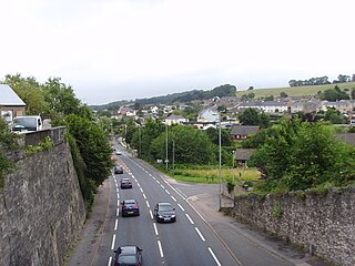
Kingskerswell is a village and civil parish within Teignbridge local government district in the south of Devon, England. The village grew up where an ancient track took the narrowest point across a marshy valley and it is of ancient foundation, being mentioned in the Domesday Book. It has a church dating back to the 14th century and the ruins of a manor house of similar date. The coming of the railway in the 1840s had a large effect on the village, starting its conversion into a commuter town. The village is a major part of the electoral ward called Kerswell-with-Combe. This ward had a population of 5,679 at the 2011 census.
The Moretonhampstead and South Devon Railway was a 7 ft 1⁄4 in broad gauge railway which linked the South Devon Railway at Newton Abbot railway station with Bovey, Lustleigh and Moretonhampstead, Devon, England.

Dunchideock is a small civil parish on the north eastern slopes of the Haldon Hills in Teignbridge, Devon, England. It covers an area of 392 hectares (970 acres) and lies about 6 km (3.7 mi) south-west of Exeter and 11 km (6.8 mi) north-east of Bovey Tracey. The parish, with a population of 262 in 2001, lacks a compact village, but consists of scattered dwellings. It is surrounded clockwise from the north by the parishes of Holcombe Burnell, Ide, Shillingford St. George, Kenn, and Doddiscombsleigh.
Teignbridge Hundred was the name of one of thirty two ancient administrative units of Devon, England.

Parke is an historic estate in the parish of Bovey Tracey in Devon, England. The present mansion house known as Parke House, a grade II listed building situated 1/2 mile west of the centre of the town of Bovey Tracey and on the opposite side of the River Bovey, was rebuilt in 1826/8 by William Hole (1799-1859) and is today the headquarters of the Dartmoor National Park Authority.

South Huish is a village and civil parish about 4 miles south west of Kingsbridge, in the South Hams district, in the county of Devon, England. The parish includes Galmpton and Hope Cove. According to the 2011 census the parish had a population of 473, the parish had an estimated population of 436 in 2017. The parish touches West Alvington, South Milton and Malborough. The parish is in the South Devon Area of Outstanding Natural Beauty.

Monkokehampton is a village and civil parish in West Devon, England. The village lies on the River Okement, about 3 miles (4.8 km) east-north-east of Hatherleigh. The parish is bounded by Hatherleigh, Exbourne, Broadwoodkelly and Iddesleigh, and had a population of 139 at the 2011 Census.
Monkton is a village and civil parish on the River Otter, about 2 miles north east of Honiton railway station, in the East Devon district, in the county of Devon, England. In 2011 the parish had a population of 169. The parish touches Cotleigh, Upottery, Honiton, Offwell and Luppitt. The parish is in the Blackdown Hills Area of Outstanding Natural Beauty.

Thrushelton or Thruselton is a village and civil parish about 2 and a half miles north of Coryton railway station, in the West Devon district, in the county of Devon, England. In 2011 the parish had a population of 197. The parish touches Bratton Clovelly, Bridestowe, Lewtrenchard, Stowford, Broadwoodwidger, Marystow and Germansweek.

Inwardleigh is a village and civil parish about 3 and a half miles north north west of Okehampton railway station, in the West Devon district, in the county of Devon, England. The parish contains the village of Folly Gate. The A386 road runs through the parish. In 2011 the parish had a population of 491. The parish touches Hatherleigh, Sampford Courtenay, Okehampton Hamlets, Jacobstowe and Northlew.

Sampford Spiney is a village and civil parish in the Walkham valley, about 4 miles east south east of Tavistock, in the West Devon district, in the county of Devon, England. In 2011 the parish had a population of 117. The parish touches Walkhampton, Whitchurch and Horrabridge.

West Anstey is a village and civil parish on the River Yeo, about 5 miles west of Dulverton, in the North Devon district, in the county of Devon, England. In 2011 the parish had a population of 163. The parish touches Molland, East Anstey and Withypool and Hawkridge.

