
Chetwode is a village and civil parish about 4 miles (6.4 km) southwest of Buckingham in the Aylesbury Vale district of Buckinghamshire. The parish is bounded to the southwest and southeast by a brook called The Birne, which here also forms part of the county boundary with Oxfordshire.

Ickleton is a village and civil parish about 9 miles (14 km) south of Cambridge in Cambridgeshire, England. The village is beside the River Cam, close to where a southern branch of the Icknield Way crossed the river. The eastern and southern boundaries of the parish form part of the county boundary with Essex, and the Essex town of Saffron Walden is only about 4.5 miles (7 km) southeast of the village.

Tywardreath is a small hilltop village on the south coast of Cornwall, England, United Kingdom, about 3 miles (5 km) north west of Fowey. It is located in a sheltered spot overlooking a silted up estuary opposite Par and near the beach of Par Sands. It is on the Saints' Way path.

Broadhempston is a village, parish and former manor in Devon, England, situated about 4 miles north of Totnes. It is now administered by Teignbridge District Council. According to the 2001 census the parish contained 257 houses with a population of 641.

Aston Cantlow is a village in Warwickshire, England, on the River Alne 5 miles (8.0 km) north-west of Stratford-upon-Avon and 2 miles (3.2 km) north-west of Wilmcote, close to Little Alne, Shelfield, and Newnham. It was the home of Mary Arden, William Shakespeare's mother. At the 2001 census, it had a population of 1,674, being measured again as 437 at the 2011 Census.

Chirbury is a village and former civil parish, now in the parish of Chirbury with Brompton, in the Shropshire district, in west Shropshire, England. It is situated in the Vale of Montgomery, close to the Wales–England border, which is to its north, west and south. The A490 and B4386 routes cross at Chirbury.

Pelynt is a civil parish and village in Cornwall, England, United Kingdom. It is 20 miles (32 km) west of Plymouth and four miles (6.5 km) west-northwest of Looe. Pelynt had a population of around 1,124 at the 2001 census which increased to 1,296 at the 2011 census. In addition, an electoral ward with the same name exists but extends towards Widegates avoiding Looe at all times. The population in 2011 for this ward was 4,453.

Kenwyn is a settlement and civil parish in Cornwall, England, United Kingdom. The settlement is a suburb of the city of Truro and lies 0.5 mi (1 km) north of the city centre, within Truro parish, whereas Kenwyn parish covers an area west and north-west of the city. Kenwyn gives its name to one of three rivers that flow through the city.

Mylor is a civil parish in Cornwall, England, United Kingdom. It is situated approximately five miles north of Falmouth.

Sithney is a village and civil parish in the West of Cornwall, England, United Kingdom. Sithney is north of Porthleven. The population including Boscadjack and Crowntown at the 2011 census was 841.

Cogges is an area beside the River Windrush in Witney, in the West Oxfordshire district, in Oxfordshire, England, 0.5 miles (800 m) east of the town centre. It had been a separate village and until 1932 it was a separate civil parish.
St Kew is a village in Cornwall, England, United Kingdom. It is also the name of the civil parish, which includes the church town, St Kew, and nearby St Kew Highway.

Whitchurch is a suburban village and civil parish to the south-east of the town of Tavistock, Devon, England. It lies in the West Devon local authority area, and within Tavistock Deanery for ecclesiastical purposes. The village itself is no longer in the civil parish, having been absorbed into Tavistock in 1930, leaving the parish of Whitchurch just covering the rural areas south-east of the town. Historically, Whitchurch formed part of the Roborough Hundred.

Hatfield Broad Oak is a village and civil parish in the Uttlesford district of Essex, England. The village is approximately 5 miles (8 km) south-east of Bishop's Stortford. Near the church of St Mary the Virgin is former Benedictine priory Hatfield Regis Priory.

Great Wolford is a village and civil parish in the Stratford-on-Avon district of Warwickshire, England. With the neighbouring parish of Little Wolford it is part of 'The Wolfords'.
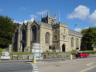
St Petroc's Church, Bodmin, also known as Bodmin Parish Church is an Anglican parish church in the town of Bodmin, Cornwall, England, United Kingdom.
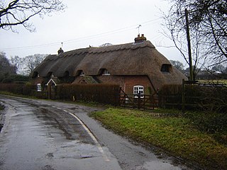
Bradley is a small village and civil parish in the Basingstoke and Deane district of Hampshire, England. Its nearest town is Alton, which lies 5.4 miles (8.7 km) southeast from the village, although Basingstoke lies 6.6 miles (10.6 km) to the north. According to the 2011 census, the village had a population of 202 people. The parish covers an area of 975 acres (395 ha), of which 149 acres (60 ha) is woodland and its highest point is 170 metres (560 ft) above sea level. It contains no hamlets.
The Parish Church of St Mary and St Petroc is a congregation of the Roman Catholic Church in Bodmin, Cornwall, England, United Kingdom. The parish church is the former monastic church of the Abbey of St Mary, a community of canons regular, whose origins on the site date back to the Middle Ages.
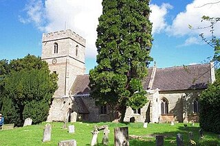
Salwarpe is a small village and civil parish in the Wychavon district of Worcestershire, England, less than two miles south west of Droitwich, but in open country. The name is also spelled Salwarp, and in the time of John Leland was recorded as Salop. Since 2003, Salwarpe has shared a parish council with Hindlip and Martin Hussingtree.

St Giles on the Heath, sometimes hyphenated as St Giles-on-the-Heath, is a village and civil parish in the far west of Devon, England. It forms part of the local government district of Torridge. The village is in the east of the parish and lies on the A388 road about eight miles south of the town of Holsworthy.


