
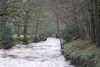
The River Teign is a river in the county of Devon, England. It is 31 mi (50 km) long and rises on Dartmoor, becomes an estuary just below Newton Abbot and reaches the English Channel at Teignmouth.

Teignbridge is a local government district in Devon, England. Its council is based in Newton Abbot.

Newton Abbot is a market town and civil parish on the River Teign in the Teignbridge District of Devon, England. Its 2011 population of 24,029 was estimated to reach 26,655 in 2019. It grew rapidly in the Victorian era as the home of the South Devon Railway locomotive works. This later became a major steam engine shed, retained to service British Railways diesel locomotives until 1981. It now houses the Brunel industrial estate. The town has a race course nearby, the most westerly in England, and a country park, Decoy. It is twinned with Besigheim in Germany and Ay in France.

Bridford is a village and civil parish in south west England, located in the Teign Valley, Devon on the edge of Dartmoor. The parish is surrounded by the parishes of Dunsford, Doddiscombsleigh, Christow, and Moretonhampstead. At the 2011 census the population of the parish was 503, compared with 404 in 1901.
The ecclesiastical title of archpriest or archpresbyter belongs to certain priests with supervisory duties over a number of parishes. The term is most often used in Eastern Orthodoxy and the Eastern Catholic Churches and may be somewhat analogous to a monsignor, vicar forane or dean in the Latin Church, but in the Eastern churches an archpriest wears an additional vestment and, typically, a pectoral cross, and becomes an archpriest via a liturgical ceremony.

Abbotskerswell is a village and civil parish in the English county of Devon. The village is in the north part of the parish and is located two miles (3 km) south of the town of Newton Abbot, 7 miles (11 km) from the seaside resort of Torquay and 32 miles (51 km) from the city of Plymouth. The A381 road between Newton Abbot and Totnes runs down the western side of the parish and the main railway line between these two towns forms part of its eastern boundary.

The Rev. William Keble Martin was a Church of England priest, botanist and botanical illustrator, known for his Concise British Flora in Colour.
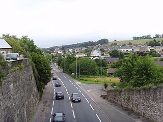
Kingskerswell is a village and civil parish within Teignbridge local government district in the south of Devon, England. The village grew up where an ancient track took the narrowest point across a marshy valley and it is of ancient foundation, being mentioned in the Domesday Book. It has a church dating back to the 14th century and the ruins of a manor house of similar date. The coming of the railway in the 1840s had a large effect on the village, starting its conversion into a commuter town. The village is a major part of the electoral ward called Kerswell-with-Combe. This ward had a population of 5,679 at the 2011 census.
Dunsford is a village in Devon, England, just inside the Dartmoor National Park.
The South Devon Football League, known under a sponsorship arrangement as the TCSSDFL, is a football competition based in England. Its top division, the Premier Division, sits at level 12 of the English football league system. This league is a feeder to the Devon Football League. There are five divisions in the league. The SDFL's primary cup competition is the Herald Cup. It is a simple knockout competition featuring all SDFL clubs.

The River Lemon is a 9.9 miles river in the county of Devon in southwest England. It is a tributary of the River Teign, starting on Dartmoor by Haytor, and ending in Newton Abbot. It rises on the south-east side of Dartmoor near Haytor, joins with the River Sig and the Langworthy Brook at Sigford, then passes the village of Bickington. Lower down, it is joined by the Kestor Brook and it then flows through the woods in Bradley Valley, past the manor house of Bradley, and through the town of Newton Abbot where it flows through a 440-yard-long tunnel below the town centre. Just below the town, the river joins the River Teign at 50.517°N 3.607°W, near the head of its estuary.

Trusham is a small village in the Teign Valley, between Newton Abbot and Exeter, in Devon, England. The name originates from the Celtic Trisma, meaning "brushwood" or "fallen leaves". It became Trisme for about 400 years, and then in the 16th century Tryssame or Trysham. A pub, the Cridford Inn, was opened in 1985 by converting part of an old farmhouse and adjoining barn.

Combeinteignhead or Combe-in-Teignhead is a village in Teignbridge, South Devon, England. It lies within the civil parish of Haccombe with Combe, between Newton Abbot and Shaldon, about half a mile (1 km) inland from the estuary of the River Teign.

Stokeinteignhead is a village and civil parish in the Teignbridge district of Devon, England, above the southern bank of the estuary of the River Teign. The parish has a short boundary on the estuary, and is otherwise surrounded, clockwise from the north, by the parishes of Shaldon, Torbay, Coffinswell and Haccombe with Combe. It is twinned with the French commune of Trévières, Calvados.

Haccombe is a village and former civil parish and historic manor, now in the parish of Haccombe with Combe, in the Teignbridge district, in the county of Devon, England. It is situated 2 1/2 miles east of Newton Abbot, in the south of the county. It is possibly the smallest parish in England, and was said in 1810 to be remarkable for containing only two inhabited houses, namely the manor house known as Haccombe House and the parsonage. Haccombe House is a "nondescript Georgian structure" (Pevsner), rebuilt shortly before 1795 by the Carew family on the site of an important mediaeval manor house. In 1881 the parish had a population of 14. On 25 March 1885 the parish was abolished and merged with Combe in Teignhead and to form "Haccombe with Combe".

The Aller Vale Pottery was formed in 1865 on the northern edge of the village of Kingskerswell in South Devon, England on the likely site of a medieval pottery. It became well known for the creation of art pottery at the end of the 19th century and gained Royal patronage, but declined thereafter, closing on this site in about 1924. The name continued in use until 1962 related to the production of mass-produced motto ware for the tourist market.
The hundred of Haytor was the name of one of thirty two ancient administrative units of Devon, England. The hundred covered the coastal area between the River Teign and River Dart. It was likely named after a lost village located somewhere between Totnes and Newton Abbot.

The Aller Brook is a stream that flows for 5.0 miles (8 km) through Devon, England. It is a primary tributary of the River Teign, which it joins near Newton Abbot.

Haccombe with Combe is a civil parish in the Teignbridge local government district of Devon, England. The parish lies immediately to the east of the town of Newton Abbot, and south of the estuary of the River Teign. Across the estuary are the parishes of Kingsteignton and Bishopsteignton. The parish is bordered on the east by Stokeinteignhead and on the south by Coffinswell. Most of the southern boundary of the parish follows the minor ridge road that runs between the suburbs of Milber in Newton Abbot and Barton in Torquay and it bisects the Iron Age hill fort of Milber Down.

Middle Rocombe is a hamlet in Devon, England. It lies just over 1 mile to the West of the nearest village, Stokeinteignhead, and is located about 3 miles from Newton Abbot, lying within the Teignbridge district of Devon. It is situated in the Rocombe valley surrounded by the neighbouring hamlets of Higher and Lower Rocombe and is bordered by Coffinswell and Haccombe over the valley. The hamlet consists of a handful of houses, including a traditional, thatched cottage.
