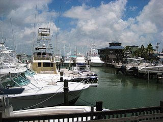
Port Aransas is a city in Nueces County, Texas, United States. This city is 180 miles southeast of San Antonio. The population was 2,904 at the 2020 census. Port Aransas is the only established town on Mustang Island. It is located north of Padre Island and is one of the longest barrier islands along the Texas coast. Corpus Christi Bay, the Gulf of Mexico, the Lydia Ann Ship Channel and the Corpus Christi Ship Channel make up the surrounding waters.
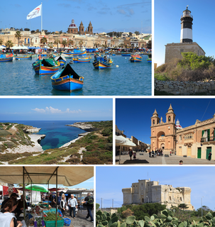
Marsaxlokk is a small, traditional fishing village in the South Eastern Region of Malta. It has a harbour, and is a tourist attraction known for its views, fishermen and history. As at March 2014, the village had a population of 3,534. The village is also known for the Marsaxlokk Market, which is mainly a large fish market which takes place along the seafront on Sundays, and a tourist market during all other days of the week. Inhabited and well-known since antiquity, Marsaxlokk was used as a port by Phoenicians, Carthaginians and also has the remains of a Roman-era harbour. Originally a part of the city of Żejtun, the fishing village became a separate parish in the late nineteenth century.

Teignmouth is a seaside town, fishing port and civil parish in the English county of Devon. It is situated on the north bank of the estuary mouth of the River Teign, about 12 miles south of Exeter. The town had a population of 14,749 at the last census in 2011.
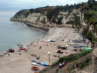
Beer is a village and civil parish in the East Devon district of Devon, England. The village faces Lyme Bay and is a little over 1 mile (1.6 km) west of the town of Seaton. It is situated on the Jurassic Coast World Heritage Site and its picturesque cliffs, including Beer Head, form part of the South West Coast Path.

Clovelly is a harbour village in the Torridge district of Devon, England. Its steep pedestrianised cobbled main street, traditional architecture, donkeys and views over the Bristol Channel attract numerous tourists. At the 2011 census, the parish population was 443, which was 50 fewer than ten years previously. The ward of Clovelly Bay includes the island of Lundy.

The Banana Islands are a group of islands that lie off the coast of Yawri Bay, south west of the Freetown Peninsula in the Western Area of Sierra Leone.
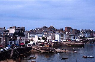
Douarnenez, is a commune in the French department of Finistère, region of Brittany, northwestern France.

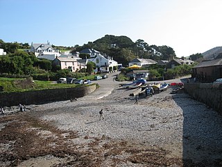
Cadgwith is a village and fishing port in Cornwall, England, United Kingdom. It is on the Lizard Peninsula between The Lizard and Coverack. It is in the civil parish of Grade Ruan.

Sennen Cove is a small coastal village in the parish of Sennen in Cornwall, England, United Kingdom. According to the Penwith District Council, the population of this settlement was estimated at 180 persons in 2000. The South West Coast Path passes through Sennen Cove.

Gorran Haven is a fishing village, in the civil parish of St Goran, on the south coast of Cornwall, England, UK. It is about 2 miles (3.2 km) south of Mevagissey and lies within the Cornwall Area of Outstanding Natural Beauty (AONB).
Port Gaverne is a hamlet on the north coast of Cornwall, England, UK, about 0.5 miles (0.80 km) east of Port Isaac and part of St Endellion parish.

Gurnard's Head is a prominent headland on the north coast of the Penwith peninsula in Cornwall, England, UK. The name is supposed to reflect that the rocky peninsula resembles the head of the gurnard fish.

A fishing village is a village, usually located near a fishing ground, with an economy based on catching fish and harvesting seafood. The continents and islands around the world have coastlines totalling around 356,000 kilometres (221,000 mi). From Neolithic times, these coastlines, as well as the shorelines of inland lakes and the banks of rivers, have been punctuated with fishing villages. Most surviving fishing villages are traditional.

Bigbury-on-Sea is a village in the South Hams district on the south coast of Devon, England. It is part of the civil parish of Bigbury which is centred on a small village of that name about a mile inland. Bigbury-on-Sea village is on the coast above the largest sandy beach in South Devon facing south to Bigbury Bay. The tidal island of Burgh Island lies about 270 yards offshore.

Combeinteignhead or Combe-in-Teignhead is a village in Teignbridge, South Devon, England. It lies within the civil parish of Haccombe with Combe, between Newton Abbot and Shaldon, about half a mile (1 km) inland from the estuary of the River Teign.

The Rosario Islands, also referred to as Corales Islas del Rosario, is an archipelago located off the coast of Colombia, approximately 100 kilometres from Cartagena. It is one of the 46 Natural National Parks of Colombia. The national park was founded in 1988, to protect one of the most important coral reefs of the Colombian Caribbean coast. People can visit the national park area of the islands, and tours are available. Isla Rosario has an aquarium and open-sea oceanarium (oceanario) that people can visit. Activities include swimming, snorkeling and fishing, among others.

Fishing in Cornwall, England, UK, has traditionally been one of the main elements of the economy of the county. Pilchard fishing and processing was a thriving industry in Cornwall from around 1750 to around 1880, after which it went into an almost terminal decline. During the 20th century the varieties of fish taken became much more diverse and crustaceans such as crab and lobster are now significant. Much of the catch is exported to France due to the higher prices obtainable there. Though fishing has been significantly damaged by overfishing, the Southwest Handline Fishermen's Association has started to revive the fishing industry. As of 2007, stocks are improving. The Cornwall Sea Fisheries Committee is one of 12 such committees responsible for managing the corresponding Sea Fisheries District. The Isles of Scilly Sea Fisheries Committee is responsible for the Scilly district.

Ringmore is a village and a civil parish located on the coast of Devon, England.The population taken at the 2011 census was 208.

The Percuil River is an estuary and stream draining the southern part of the Roseland Peninsula of Cornwall, UK and is one of three major tidal creeks of the River Fal. The small port and holiday destination of St Mawes is on the western shore and is linked to Place Creek on the eastern shore by the Place Ferry. The ferry is used by walkers on the South West Coast Path.
Haccombe with Combe is a civil parish in the Teignbridge local government district of Devon, England. The parish lies immediately to the east of the town of Newton Abbot, and south of the estuary of the River Teign. Across the estuary are the parishes of Kingsteignton and Bishopsteignton. The parish is bordered on the east by Stokeinteignhead and on the south by Coffinswell. Most of the southern boundary of the parish follows the minor ridge road that runs between the suburbs of Milber in Newton Abbot and Barton in Torquay and it bisects the Iron Age hill fort of Milber Down.

