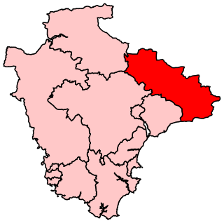
Halberton

Last updated

Halberton
St Andrew's Church, Halberton, Devon 01.jpg
The parish church, St Andrew's
Devon UK location map.svg
Red pog.svg
Halberton
Location within Devon
Population1,971 (2021 census) [1]
OS grid reference SS955125
Civil parish
  • Halberton
District
Shire county
Region
Country England
Sovereign state United Kingdom
Post town Tiverton
Postcode district EX16
Dialling code 01884
Police Devon and Cornwall
Fire Devon and Somerset
Ambulance South Western
UK Parliament
List of places
UK
England
Devon
50°54′09″N3°29′15″W / 50.9025°N 3.4875°W / 50.9025; -3.4875

Halberton is a village and civil parish in Devon, England. It is situated between the historic market towns of Tiverton and Cullompton. The Grand Western Canal runs around to the north and west of the village.

Contents

The large parish has an area of about 7,520 acres (30.4 km2) [2] and it is surrounded, clockwise from the north, by the parishes of Uplowman, Sampford Peverell, Burlescombe, Uffculme, Willand, Cullompton, Butterleigh, Silverton, Bickleigh and Tiverton. [3] The parish includes the small village of Ash Thomas as well as the hamlet of Brithem Bottom. The population of the parish at the 2021 census was 1,971, [1] whilst the population of the village itself was recorded by that census as 892. [4] Changes to the parish boundary, involving transfers of residential and industrial areas to Uffculme and Willand respectively, occurred in 2023. [5]

History

Its name is derived from ‘Haligbeort’ (Albert), the name of the Saxon chief, and ‘tun’, a farm settlement; the Halberton area is still largely a farming community. Halberton was once important enough to be a hundred, a long-standing administrative division of the county. The hundred of Halberton included the parishes of Halberton, Sampford Peverell and Willand, as well as parts of Uplowman and Burlescombe. Many of the farms date back to the time of the Domesday Book or shortly after.

Geography

There is an electoral ward with the same name, which comprises the parishes of Halberton and Butterleigh. [6] The current ward came into effect in May 2023 – previously, the ward comprised Halberton and Uplowman. [6] The population of the Halberton ward (including Uplowman) at the 2021 census was 2,330. [7]

Halberton village is informally divided into two parts – Higher Town and Lower Town – which are separated by the mill stream and pond.

National Cycle Route 3 passes through the village.

Features

A gold guinea of William III, dating from 1695, found in Halberton in 2019 Post medieval coin, guinea of William III (FindID 985261).jpg
A gold guinea of William III, dating from 1695, found in Halberton in 2019

There are several old houses in the village, the most notable being ‘The Priory’, believed to date from the 14th century, when it was part of a college called St. Jude's. This was occupied by monks of the order of St. Augustine. The building known to be the oldest is the Mill House, which was registered in the Doomsday Book (1086) as town mills. Townsend House (now demolished) dated from the early 18th century, and several other houses in the village date from the 17th and 18th centuries.

The parish church, dedicated to Saint Andrew, is grade I listed [9] and dates from the 14th century. It stands at the centre of the village, and is thought to have been constructed on the site of an earlier Saxon church. There is also a Methodist Chapel at which John Wesley preached, first in 1760, and again between 1779 and 1789. Halberton also has a Christian Fellowship Group, which meets in Ash Thomas Church.

Grand Western Canal at Halberton, seen from Manley Bridge, looking towards Tiverton. Gradnwesterncanalhalberton.jpg
Grand Western Canal at Halberton, seen from Manley Bridge, looking towards Tiverton.

The Great Western Railway once had a branch line running through Halberton to Tiverton, with a halt at Lower Town, but both the line and the station have now gone. However, the Grand Western Canal still runs through the parish and, although navigable, this is now a country park. It is 11 miles (18 km) long, running from Tiverton to Loudwells. Rock Bridge was constructed to carry the road (formerly the A373) over the canal. [10] The same engineers that built the canal also built a substantial country house, [11] turnpike house [12] and cottages [13] at the site. Several other bridges were also constructed at Halberton to carry minor roads over the canal. [14] [15] [16] [17] [18] [19]

Community

The Primary School, erected in 1844 and now grade II listed, has seen many changes and extensions over the years, and although still small is well equipped with modern equipment.[ citation needed ]

There is an active parish council, and many other organisations which cater for all tastes, including a Women's Institute and a branch of the British Legion. There is a public house in the village, called the Hickory Inn, formerly The Barge. [20]

Related Research Articles

<span class="mw-page-title-main">Tiverton, Devon</span> Town in Devon, England

Tiverton is a town and civil parish in Devon, England, and the commercial and administrative centre of the Mid Devon district. The population in 2019 was 20,587.

The Grand Western Canal ran between Taunton in Somerset and Tiverton in Devon in the United Kingdom. The canal had its origins in various plans, going back to 1796, to link the Bristol Channel and the English Channel by a canal, bypassing Lands End. An additional purpose of the canal was the supply of limestone and coal to lime kilns along with the removal of the resulting quicklime, which was used as a fertiliser and for building houses. This intended canal-link was never completed as planned, as the coming of the railways removed the need for its existence.

<span class="mw-page-title-main">River Culm</span> River in Devon, England

The River Culm flows through the Devon Redlands in Devon, England and is the longest tributary of the River Exe. It rises in the Blackdown Hills at a spring near RAF Culmhead in Somerset, and flows west through Hemyock, then Culmstock to Uffculme. The river turns south, through Cullompton, skirting the northern boundary of Killerton Park to join the River Exe on the north-western outskirts of Exeter. The name of the river is thought to mean 'knot' or 'tie', in reference to the river's twists and loops.

<span class="mw-page-title-main">Tiverton Parkway railway station</span> Railway station in Devon, England

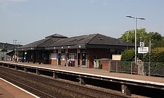
Tiverton Parkway railway station is on the Bristol to Exeter line in Devon, England. Despite being named after the town of Tiverton it is actually located in the civil parish of Burlescombe, near Sampford Peverell, 6 miles (9.7 km) to the east of Tiverton, and close to the junction of the M5 motorway with the A361 North Devon link road. It is 177 miles 28 chains from the zero point at London Paddington via Bristol Temple Meads.

<span class="mw-page-title-main">Willand</span> Village in Mid Devon, England

Willand is a village and civil parish in Mid Devon, England. It is about 19 km (12 mi) north of Exeter and 2.4 km (1.5 mi) north of Cullompton. In 1991 the population was 3750 although recently this has grown considerably. The National Grid reference for the centre of the area is ST037110. Willand is a major part of Lower Culm electoral ward. The ward population at the 2011 Census was 5,808. The parish is surrounded, clockwise from the north, by the parishes of Halberton, Uffculme and Cullompton.

<span class="mw-page-title-main">Burlescombe</span> Village in Devon, England

Burlescombe is a village and civil parish in the Mid Devon district of Devon, England. The parish is surrounded, clockwise from the north, by the parishes of Holcombe Rogus, Culmstock, Uffculme, Halberton and Sampford Peverell. According to the 2001 census it had a population of 911. The village is about 5 miles (8.0 km) south west of Wellington in Somerset. The ruins of the 12th century Canonsleigh Abbey are nearby. Burlescombe is part of the electoral ward of Canonsleigh. The population of this ward was 3,218 at the 2011 Census.

<span class="mw-page-title-main">Holcombe Rogus</span> Village in Devon, England

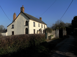
Holcombe Rogus is a village, civil parish and ecclesiastical parish in the English county of Devon. In 2001 the population of the parish was 503.
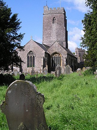
<span class="mw-page-title-main">Sampford Peverell</span> Village in Devon, England

<span class="mw-page-title-main">Uffculme</span> Village in Mid Devon, England

Uffculme is a village and civil parish located in the Mid Devon district, of Devon, England. Situated in the Blackdown Hills on the B3440, close to the M5 motorway and the Bristol–Exeter railway line, near Cullompton, Uffculme is on the upper reaches of the River Culm. The population of the parish, according to a 2020 estimate, is 3,090. It is surrounded, clockwise from the north, by the parishes of Culmstock, Hemyock, Sheldon, Kentisbeare, Cullompton, Willand, Halberton and Burlescombe.

<span class="mw-page-title-main">Tiverton (UK Parliament constituency)</span>

Tiverton was a constituency located in Tiverton in east Devon, formerly represented in the House of Commons of the Parliament of the United Kingdom. Enfranchised as a parliamentary borough in 1615 and first represented in 1621, it elected two Members of Parliament (MPs) by the first past the post system of election until 1885. The name was then transferred to a county constituency electing one MP.

<span class="mw-page-title-main">Culmstock</span> Village and civil parish in Devon, England

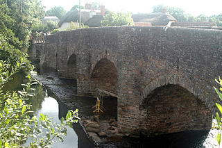
Culmstock is a village and civil parish in Mid Devon, England, centred 10 miles from Tiverton and 6 NE of Cullompton. It is laid out on both sides of the River Culm; the village is joined by a single old narrow stone bridge across the river. The population of the parish at the 2011 Census was 554. The northern boundary of the parish forms part of the Devon – Somerset border and clockwise from there it is surrounded by the Devon parishes of Hemyock, Uffculme, Burlescombe and Holcombe Rogus.

The hundred of Halberton was the name of a small district, one of thirty two ancient administrative units of Devon, England.

Uffculme School is a mixed secondary school located in Uffculme in the English county of Devon.

<span class="mw-page-title-main">Uplowman</span> Village and civil parish in Devon, England

Uplowman is a village and civil parish in Devon, situated about 4 miles north-east of the town of Tiverton. The parish is surrounded, clockwise from the north, by the parishes of Hockworthy, Sampford Peverell, Halberton, Tiverton, and Huntsham. It is situated near the River Lowman, and further downstream, to the west, is Crazelowman.

<span class="mw-page-title-main">Moor Hayes</span> Historic estate in Devon, England

Moor Hays is a historic estate in the parish of Cullompton in Devon, England. It is stated incorrectly to be in the nearby parish of Burlescombe in Tristram Risdon's Survey of Devon. The estate is not to be confused with Moor Hayes in the parish of Washfield, about 3 miles north-west of Tiverton, another ancient farmstead, which since 2005 has been the site of a large housing estate named "Moorhayes".

References

  1. 1 2 CityPopulation.de Halberton (Parish, United Kingdom)
  2. "An Introduction". Halberton Parish. Retrieved 15 July 2016.
  3. "Map of Devon Parishes" (PDF). Devon County Council. Archived from the original (PDF) on 2 November 2013. Retrieved 7 July 2016.
  4. CityPopulation.de Halberton (Devon, United Kingdom)
  5. Halberton Parish Council Halberton Parish Boundary Change 1-May-2023
  6. 1 2 LGBCE Mid-Devon
  7. CityPopulation.de Halberton (Ward, United Kingdom)
  8. Shipley, L. "Finds record for: DEV-38F9E9". The Portable Antiquities Scheme. Retrieved 26 August 2022.
  9. Historic England Parish Church of St Andrew
  10. Historic England. "Rock Bridge at Halberton (1106646)". National Heritage List for England . Retrieved 6 December 2007.
  11. Historic England. "Rock House and adjacent range of outbuildings (1306712)". National Heritage List for England . Retrieved 6 December 2007.
  12. Historic England. "Turnpike Cottage (1106648)". National Heritage List for England . Retrieved 6 December 2007.
  13. Historic England. "Cottage 100 metres east of Rock - House (1106647)". National Heritage List for England . Retrieved 6 December 2007.
  14. Historic England. "Batten's Bridge (1105877)". National Heritage List for England . Retrieved 6 December 2007.
  15. Historic England. "Accommodation bridge over the Grand Western Canal (1105879)". National Heritage List for England . Retrieved 6 December 2007.
  16. Historic England. "Bridge at Halberton (1326158)". National Heritage List for England . Retrieved 6 December 2007.
  17. Historic England. "Crownhills Bridge (1105883)". National Heritage List for England . Retrieved 6 December 2007.
  18. Historic England. "Greenway Bridge (1106641)". National Heritage List for England . Retrieved 6 December 2007.
  19. Historic England. "Sellick Bridge (1105890)". National Heritage List for England . Retrieved 6 December 2007.
  20. WhatPub.com Hickory Inn, Halberton