
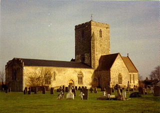
Chetwode is a village and civil parish about 4 miles (6.4 km) southwest of Buckingham in the Aylesbury Vale district of Buckinghamshire. The parish is bounded to the southwest and southeast by a brook called The Birne, which here also forms part of the county boundary with Oxfordshire.

Braunton is an English village, civil parish, ecclesiastical parish and former manor in Devon. The village is situated 5 miles (8 km) west of Barnstaple. It is one of the largest villages in Devon with a population at the 2021 census of 10,217 people. There are two electoral wards. Their joint population at the above census was 8,218. Within the parish is the fertile, low-lying Braunton Great Field, which adjoins the undulating Braunton Burrows, the Core Area in North Devon Biosphere Reserve, the largest psammosere in England. It confronts the Atlantic Ocean at the west of the parish at the large beach of Saunton Sands, one of the South West's international-standard surfing beaches.

Affpuddle is a small village in the Purbeck district of Dorset in South West England, 9 miles (14 km) east of Dorchester. The local travel links are 3 miles (4.8 km) from the village to Moreton railway station and 20 miles (32 km) to Bournemouth International Airport. Part of the village street is the B3390, which divides the village into two. Affpuddle used to have its own civil parish, which included the settlements of Briantspuddle to the east and Pallington to the south. In the 2001 census this parish had a population of 402. Affpuddle civil parish has since joined with neighbouring Turners Puddle to form the new parish of Affpuddle and Turnerspuddle. In the 2011 census this joint parish had 200 households and a population of 436.

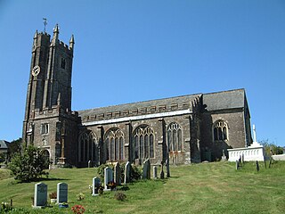
Hemyock is a village and civil parish in Devon, England. It is about 8 miles north-west of Honiton and 5 miles (8 km) south of the Somerset town of Wellington. The 2011 Census recorded the parish's population as 1,519. Hemyock is part of the electoral ward of Upper Culm. The population of this ward at the above census was 4,039. The River Culm flows through Hemyock. Hemyock was the former home of the St Ivel dairy processing plant, formerly where the butter-spreads 'St Ivel Gold' and 'Utterly-Butterly' were produced before being moved to a factory in the north of England.

Turvey is a village and civil parish on the River Great Ouse in Bedfordshire, England, about 6 miles (9.7 km) west of Bedford. The village is on the A428 road between Bedford and Northampton, close to the border with Buckinghamshire. The 2011 Census recorded the parish's population as 1,225.
Cholsey is a village and civil parish 2 miles (3 km) south of Wallingford in South Oxfordshire. In 1974 it was transferred from Berkshire to Oxfordshire, and from Wallingford Rural District to the district of South Oxfordshire. The 2011 Census recorded Cholsey's parish population as 3,457. Cholsey's parish boundaries, some 17 miles (27 km) long, reach from the edge of Wallingford into the Berkshire Downs. The village green is called "The Forty" and has a substantial and ancient walnut tree.

Mortehoe is a village and former manor on the north coast of Devon, England. It lies 10 miles north-west of Barnstaple, near Woolacombe and Lee Bay, and is sited in a valley within the hilly sand-dune-like land behind Morte Point, almost directly above Woolacombe. The parish population at the 2011 census was 1,637.

Atherington is a village and civil parish in the North Devon district of Devon, England, about 8 miles south of Barnstaple. According to the 2001 census the parish had a population of 391.

Berry Pomeroy is a village and civil parish in the South Hams district of Devon, England, 2 miles (3 km) east of the town of Totnes. The parish is surrounded clockwise from the north by the parishes of Ipplepen, Marldon, Torbay, Stoke Gabriel, Ashprington, Totnes, and Littlehempston. In 2001 its population was 973, down from 1193 in 1901. The main road access is via the A385 road between Paignton and Totnes that runs through the parish, south of the village.
Blisland is a village and civil parish in Cornwall, England, United Kingdom. It is approximately five miles northeast of Bodmin. According to the 2001 census, the parish had a population of 565. This had increased to 608 at the 2011 census.

Buckland Monachorum is a village and civil parish in the West Devon district of Devon, England, situated on the River Tavy, about 10 miles north of Plymouth.

Huttoft is a village in the East Lindsey district of Lincolnshire, England, about 4 miles (6 km) east of the market town of Alford, on the A52 road between Ingoldmells and Sutton-on-Sea. John Betjeman, later England's Poet Laureate, visited Huttoft in the 1940s and devoted a poem to its parish church.

Newbold Astbury is a village and civil parish in the unitary authority of Cheshire East and the ceremonial county of Cheshire, in the north-west of England.

Willington is a village and civil parish located in the English county of Bedfordshire. It is west of Moggerhanger on the road from Sandy to Bedford. The village is recorded in the Domesday Book as Welitone and as Wilitona in c. 1150, from Old English tun (homestead) among the willows, and is part of the ancient hundred of Wixamtree.
Harberton is a village, civil parish and former manor 3 miles south west of Totnes, in the South Hams District of Devon, England. The parish includes the village of Harbertonford situated on the main A381 road. In the 2001 census the parish had a population of 1,285. The village is a major part of the electoral ward of Avon and Harbourne. At the 2011 census the ward population was 2,217.

Frithelstock is a village, civil parish and former manor in Devon, England. It is located within Torridge local authority area and formed part of the historic Shebbear hundred. The parish is surrounded, clockwise from the north, by the parishes of Monkleigh, Great Torrington, Little Torrington, Langtree and Buckland Brewer. In 2001 its population was 366, down from 429 in 1901.

Notgrove is a village and civil parish in Gloucestershire, England, approximately 28.5 to the east of Gloucester. It lies in the Cotswolds, an Area of Outstanding Natural Beauty.

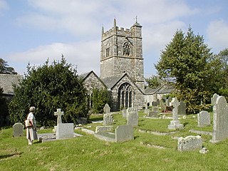
Molland is a small village, civil parish, dual ecclesiastical parish with Knowstone, located in the foothills of Exmoor in Devon, England. It lies within the North Devon local government district. At the time of the 2001 Census, the village had 203 inhabitants. Molland was first referenced as the Manor of Molland in the Domesday Book. The village contains a church dating back to the 1400s.
Coleshill is a village and civil parish in the Vale of White Horse district of Oxfordshire, England. Coleshill was part of Berkshire until the 1974 boundary changes transferred it to Oxfordshire. The village is beside the River Cole, which forms both the western boundary of the parish and also the county boundary with Wiltshire. Coleshill is about 3 miles (5 km) west of the market town of Faringdon, about 2 miles (3 km) east of the Wiltshire town of Highworth. The village is on the B4019 road that links the two towns. The 2011 Census recorded the population of the parish as 156.

Huish is a small village, civil parish and former manor in the Torridge district of Devon, England. The eastern boundary of the parish is formed by the River Torridge and the western by the Rivers Mere and Little Mere, and it is surrounded, clockwise from the north, by the parishes of Merton, Dolton, Meeth and Petrockstowe. In 2001 the population of the parish was 49, down from 76 in 1901.

