Bridford

Last updated

Bridford
Bridford - near the church - geograph.org.uk - 991692.jpg
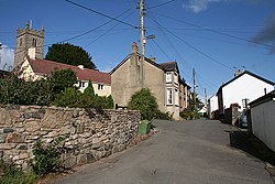
Bridford: near the church
Devon UK location map.svg
Red pog.svg
Bridford
Location within Devon
Population503  [1]
OS grid reference SX816865
Shire county
Region
Country England
Sovereign state United Kingdom
Post town Exeter
Postcode district EX6
Dialling code 01647
Police Devon and Cornwall
Fire Devon and Somerset
Ambulance South Western
UK Parliament
List of places
UK
England
Devon
50°39′58″N3°40′30″W / 50.666°N 3.675°W / 50.666; -3.675 Coordinates: 50°39′58″N3°40′30″W / 50.666°N 3.675°W / 50.666; -3.675

Bridford is a village and civil parish in south west England, located in the Teign Valley, Devon on the edge of Dartmoor. The parish is surrounded (clockwise from the north) by the parishes of Dunsford, Doddiscombsleigh, Christow, and Moretonhampstead. [2] At the 2011 census the population of the parish was 503, [1] compared with 404 in 1901. [3]

Contents

History

The place-name 'Bridford' is first attested in a charter of circa 1080, where surprisingly it appears as Bridaford. It is recorded as Brideforda in the Domesday Book of 1086. The name means 'brides' ford', and has the same derivation as Britford in Wiltshire. [4]

Today

Bridford has a village pub called the Bridford Inn, which incorporates the village shop. The Post Office visits every Friday in the village hall, and the doctor's surgery is open five days a week in neighbouring Christow. Moorgate vets have a small surgery just outside the village, and there is a MOT and general servicing garage and garden centre within a mile of Bridford. There is a children's play park, a village garden and a village hall. The village also has a two-acre Woodland Trust nature reserve and Rowdon Woods. It is well served by buses to both Exeter and Newton Abbot.

Bridford's church is dedicated to St Thomas Becket. There is also a tiny Methodist chapel in the centre of the village.

The village has clubs such as scouts, women's institute, darts and skittles teams. Teign Valley Golf Club is four miles away and there is a football pitch and tennis courts in Christow two miles distant.

Children from Bridford go to neighbouring primary schools in the neighbouring villages of Christow, Dunsford or Doddiscombsleigh. They then attend Teign school, an Academy.

Bridford has its annual village summer fête in July. It is twinned with Saint-Vaast-sur-Seulles, a village in the Normandy region of France.

Related Research Articles

<span class="mw-page-title-main">River Teign</span> River in Devon, England

The River Teign is a river in the county of Devon, England. It is 31 mi (50 km) long and rises on Dartmoor, becomes an estuary just below Newton Abbot and reaches the English Channel at Teignmouth.

<span class="mw-page-title-main">Teignbridge</span> Non-metropolitan district in England

Teignbridge is a local government district in Devon, England. Its council is based in Newton Abbot.

<span class="mw-page-title-main">Christow</span> Village in Devon, England

Christow is a village and civil parish in the Teignbridge district of Devon, England, about 12 miles (19 km) southwest of Exeter. The village is in the Teign Valley, just off the B3193 road that links Chudleigh and Dunsford. Christow is on the eastern edge of Dartmoor National Park.

<span class="mw-page-title-main">Shaldon</span> Village in Devon, England

Shaldon is a village and civil parish in South Devon, England, on the south bank of the estuary of the River Teign, opposite Teignmouth. The village is a popular bathing place and is characterised by Georgian architecture.

Culcheth is a village in the Borough of Warrington, England, six miles (10 km) north-east of Warrington town centre; it is the principal settlement in Culcheth and Glazebury civil parish.

<span class="mw-page-title-main">Doddinghurst</span> Human settlement in England

Doddinghurst is a village and civil parish in the Borough of Brentwood, in south Essex. It is 3 miles (5 km) to the north of Brentwood.

<span class="mw-page-title-main">Kingskerswell</span> Village in Devon, England

Kingskerswell is a village and civil parish within Teignbridge local government district in the south of Devon, England. The village grew up where an ancient track took the narrowest point across a marshy valley and it is of ancient foundation, being mentioned in the Domesday Book. It has a church dating back to the 14th century and the ruins of a manor house of similar date. The coming of the railway in the 1840s had a large effect on the village, starting its conversion into a commuter town. The village is a major part of the electoral ward called Kerswell-with-Combe. This ward had a population of 5,679 at the 2011 census.

<span class="mw-page-title-main">Dunsford</span> Village in Devon, England

Dunsford is a village in Devon, England, just inside the Dartmoor National Park.

<span class="mw-page-title-main">Coffinswell</span> Village in Devon, England

Coffinswell is a small village in South Devon, England, just off the A380, the busy Newton Abbot to Torquay road. It lies within Teignbridge District Council.

<span class="mw-page-title-main">Feniton</span> Village in Devon, England

Feniton is a village and civil parish in East Devon in the English county of Devon. The village lies about 4 miles (6.4 km) west of Honiton, 3 miles (4.8 km) north of Ottery St Mary, and 2 miles (3.2 km) east of Talaton.

<span class="mw-page-title-main">Teign Valley line</span> Disused railway line in Devon, England

The Teign Valley line was a single-track railway line that ran from Heathfield, Devon, to Exeter via the Teign Valley. It joined the South Devon main line at Exeter City Basin Junction.

<span class="mw-page-title-main">Drewsteignton</span> Village in Devon, England

Drewsteignton is a village, civil parish and former manor within the administrative area of West Devon, England, also lying within the Dartmoor National Park. It is located in the valley of the River Teign, 13 miles (21 km) west of Exeter and 9 miles (14 km) south east of Okehampton. Visitor attractions in the area include the village centre itself, nearby Castle Drogo, and Fingle Bridge. The population of the ward at the 2011 census was 1,616.

<span class="mw-page-title-main">Stokeinteignhead</span> Village in Devon, England

Stokeinteignhead is a village and civil parish in the Teignbridge district of Devon, England, above the southern bank of the estuary of the River Teign. The parish has a short boundary on the estuary, and is otherwise surrounded, clockwise from the north, by the parishes of Shaldon, Torbay, Coffinswell and Haccombe with Combe. It is twinned with the French commune of Trévières, Calvados.

<span class="mw-page-title-main">Ashton railway station</span> Disused railway station in Devon, England

Ashton railway station was a railway station serving the village of Ashton in Devon, England. It was located on the Teign Valley line.

<span class="mw-page-title-main">Doddiscombsleigh</span> Village in Devon, England

Doddiscombsleigh is a small settlement in Devon, England. It is 5 miles (8 km) southwest of the city of Exeter and one mile East of the River Teign and the Teign Valley. Along with a few other places in Devon, it is one of the longest place names in England with 16 letters.

<span class="mw-page-title-main">Trusham railway station</span> Disused railway station in Devon, England

Trusham Railway Station was a railway station in the parish of Chudleigh, serving the villages of Trusham and Hennock in Devon, England, on the Teign Valley line between Newton Abbot and Exeter.

<span class="mw-page-title-main">Christow railway station</span> Disused railway station in Devon, England

Christow Railway Station's previously known as Teign House was a railway station serving the villages of Christow, Bridford and Doddiscombsleigh in Devon, England located on the line between Newton Abbot and Exeter. The station is/was actually in the parish of Doddiscombsleigh as the parish boundary is the River Teign.

Dunsford Halt was a railway station serving Dunsford, a small village in Devon, England, on the Teign Valley Line between the towns of Newton Abbot and Exeter.

Longdown was a railway station serving Longdown, a small village in Devon, England located on the Teign Valley Line between the towns of Newton Abbot and Exeter. Longdown is in the parish of Holcombe Burnell, south of the A30 road, about four miles west of Exeter.

<span class="mw-page-title-main">Ide Halt railway station</span> Disused railway station in Devon, England

Ide Halt was a railway station serving Ide, a small village in Devon, England located on the Teign Valley Line between Newton Abbot and Exeter.

References

  1. 1 2 "Bridford Parish". Neighbourhood Statistics. Office for National Statistics. Retrieved 14 January 2017.
  2. "Map of Devon Parishes" (PDF). Devon County Council. Archived from the original (PDF) on 2 November 2013. Retrieved 7 July 2016.
  3. Harris, Helen (2004). A Handbook of Devon Parishes. Tiverton: Halsgrove. pp. 29–30. ISBN   1-84114-314-6.
  4. Eilert Ekwall, The Concise Oxford Dictionary of English Place-names, p.64.