Axminster is a market town and civil parish on the eastern border of the county of Devon in England. It is 28 miles (45 km) from the county town of Exeter. The town is built on a hill overlooking the River Axe which heads towards the English Channel at Axmouth, and is in the East Devon local government district. At the 2001 census, it had a population of 5,626, increasing to 5,761 at the 2011 census. The town contains two electoral wards the total sum of both wards being a population of 7,110. The market is still held every Thursday.

Chesterton is a former mining village in the unparished area of Newcastle-under-Lyme, in the Newcastle-under-Lyme district, in Staffordshire, England.
Bishopstone is a village and former civil parish, now in the parish of Seaford, in the Lewes district, in the county of East Sussex, England. Bishopstone Village has a population of about 200 people, including the nearby hamlet of Norton. It is located on a no-through country lane west of the town of Seaford, in the South Downs National Park.

Wolferton is a village and former civil parish, now in the parish of Sandringham, in the King's Lynn and West Norfolk district, in the county of Norfolk, England. It is 2 miles west of Sandringham, 7½ miles north of King's Lynn and 37¼ miles northwest of Norwich. In 1931 the parish had a population of 185. On 1 April 1935 the parish was abolished and merged with Sandringham.

Worthing is a small village and former civil parish, now in the parish of Hoe and Worthing, in the Breckland district, in the county of Norfolk, England. The civil parish of Worthing is now merged with that of the neighbouring village of Hoe, though the ecclesiastical parishes are still separate. In 1931 the parish had a population of 120. On 1 April 1935 Worthing was abolished and merged with Hoe, the renamed parish is now called "Hoe and Worthing".

Newton Ferrers is a village and former manor, civil and ecclesiastical parish, now in the parish of Newton and Noss, in the South Hams district, in the county of Devon, England. It is situated on a creek of the River Yealm estuary, about 6 miles (10 km) south-east of the City of Plymouth. It lies within the South Devon Area of Outstanding Natural Beauty. According to the United Kingdom Census 2011 the population of the village of Newton Ferrers was 1,268 and that of the electoral ward of Newton and Noss was 1,814.
The Lyme Regis branch line was a railway branch line connecting the seaside town of Lyme Regis with the main line railway network at Axminster, running through picturesque rural countryside on the Dorset - Devon border.

Newchapel is a village and former civil parish, now in the parish of Kidsgrove, in the Newcastle-under-Lyme district, in the county of Staffordshire, England. In 1951 the parish had a population of 4135.

Tuttington is a village and former civil parish, now in the parish of Burgh and Tuttington, in the Broadland district, in the county of Norfolk, England. The village is 11.1 miles south of Cromer, 15 miles north of Norwich and 129 miles north-east of London. The village lies 3 miles east of the nearby town of Aylsham.

Allhallows College, previously known as Allhallows School, was a private public school for boys in Devon, in the west of England. Predominantly a boarding school, but with some day boys, it was founded in Honiton about 1515, moved to a new home at Rousdon in the 1930s, and was closed in 1998, after a fall in the number of boys had led to a financial crisis.

Rousdon is a village and former civil parish, now in the parish of Combpyne Rousdon, in the East Devon district, in the county of Devon, England. It is off the A3052 road between Colyford and Lyme Regis in Dorset. In 1931 the parish had a population of 41. On 1 April 1939 the parish was abolished to form "Combpyne Rousdon".

Sidbury is a large village and former civil parish north of Sidmouth, now in the parish of Sidmouth, in the East Devon district, in the county of Devon, England. In 2011 the built-up area had a population of 457.
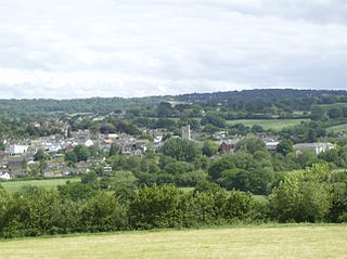
Newton Poppleford is a large village and former civil parish situated on the A3052 road between Exeter and Sidmouth on the west side of the River Otter, now in the parish of Newton Poppleford and Harpford in the East Devon district, in the county of Devon, England, within the East Devon AONB. Newton Poppleford is twinned with Crèvecœur-en-Auge in Normandy, France. In 2019 it had an estimated population of 1784.

Salcombe Regis is a coastal village and former civil parish, now in the parish of Sidmouth, in the East Devon district, in the county of Devon, England. Mentioned in the Domesday Book as "a manor called Selcoma" held by Osbern FitzOsbern, bishop of Exeter, the manor house stood on the site now occupied by Thorn Farm. The thorn tree growing in an enclosure at the road junction above the farm marked the cultivation boundary between manor and common ground. In 1951 the parish had a population of 869. On 1 April 1974 the parish was abolished and merged with Sidmouth.
Combpyne railway station was the intermediate station on the Lyme Regis branch line in East Devon, England. Serving the village of Combpyne, it was sited high on the sharp bend that changed the course of the line from south to an easterly direction.
Charles is a village and former civil parish, now in the parish of Brayford, in the North Devon district of Devon, England. Its nearest town is South Molton, which lies approximately 4.7 miles (7.6 km) south-east from the hamlet, just off the A399 road. In 1961 the parish had a population of 203. On 1 April 1986 the parish was abolished and merged with Brayford.

Moreleigh or Morleigh is a village and former civil parish, now in the parish of Halwell and Moreleigh, in the South Hams, district, in the county of Devon, England. In 1961 the civil parish had a population of 102.

Calverleigh is a village and former civil parish and manor, now in the parish of Loxbeare, in the Mid Devon district, in the county of Devon, England. It is situated 2 miles north-west of Tiverton. The parish church is dedicated to St Mary. The resident lords of the manor were for many generations the Calwoodleigh family. In 1881 the parish had a population of 83. On 25 March 1885 the parish was abolished and merged with Loxbeare.

The Axmouth to Lyme Regis Undercliffs, also often referred to in the singular as the Undercliff, is a 5-mile (8.0 km) long landscape feature, National Nature Reserve and Site of Special Scientific Interest that connects Seaton and Axmouth with Lyme Regis on the south-west coast of England. Like its namesake on the Isle of Wight, this feature arose as a result of landslips, where a slump of harder strata over softer clay gave rise to irregular landscapes of peaks, gullies and slipped blocks. Because of the resulting difficulty of access and change of land use, the undercliff has become densely vegetated, and has become a rare and unusual habitat for plants and birds.

Honeychurch is a village and former civil parish now in the parish of Sampford Courtenay, in the West Devon district of the English county of Devon. It was originally an ancient parish in the Black Torrington hundred of northwest Devon.


