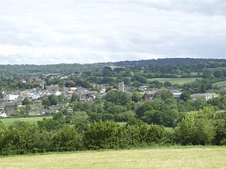
Axminster is a market town and civil parish on the eastern border of the county of Devon in England. It is 28 miles (45 km) from the county town of Exeter. The town is built on a hill overlooking the River Axe which heads towards the English Channel at Axmouth, and is in the East Devon local government district. At the 2001 census, it had a population of 5,626, increasing to 5,761 at the 2011 census. The town contains two electoral wards whose combined population is 7,110. The market is still held every Thursday.

The River Axe is a 22-mile (35 km) long river in the counties of Dorset, Somerset and Devon, in the south-west of England. It rises in Dorset and flows south to Lyme Bay which it enters through the Axe Estuary in Devon. It is a shallow, non-navigable river, although its mouth at Seaton has some boating activity. The name Axe derives from a Common Brittonic word meaning "abounding in fish", and is cognate with pysg, the Welsh word for fish.

Lyme Regis is a town in west Dorset, England, 25 miles (40 km) west of Dorchester and east of Exeter. Sometimes dubbed the "Pearl of Dorset", it lies by the English Channel at the Dorset–Devon border. It has noted fossils in cliffs and beaches on the Jurassic Coast, a World Heritage Site and heritage coast. The harbour wall, known as The Cobb, appears in Jane Austen's novel Persuasion, the John Fowles novel The French Lieutenant's Woman and the 1981 film of that name, partly shot in the town.

The Jurassic Coast is a World Heritage Site on the English Channel coast of southern England. It stretches from Exmouth in East Devon to Studland Bay in Dorset, a distance of about 96 miles (154 km), and was inscribed on the World Heritage List in mid-December 2001.

The South West Coast Path is England's longest waymarked long-distance footpath and a National Trail. It stretches for 630 miles (1,014 km), running from Minehead in Somerset, along the coasts of Devon and Cornwall, to Poole Harbour in Dorset. Because it rises and falls with every river mouth, it is also one of the more challenging trails. The total height climbed has been calculated to be 114,931 ft (35,031 m), almost four times the height of Mount Everest. It has been voted 'Britain's Best Walking route' twice in a row by readers of The Ramblers' Walk magazine, and regularly features in lists of the world's best walks.
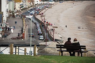
Seaton is a seaside town, fishing harbour and civil parish in East Devon on the south coast of England, between Axmouth and Beer. It faces onto Lyme Bay and is on the Jurassic Coast, a World Heritage Site. A sea wall provides access to the mostly shingle beach stretching for about a mile, and a small harbour on the River Axe estuary.
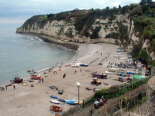
Beer is a seaside village and civil parish in the East Devon district of Devon, England. The village faces Lyme Bay and is a little over 1 mile (1.6 km) west of the town of Seaton. It is situated on the Jurassic Coast World Heritage Site and its picturesque cliffs, including Beer Head, form part of the South West Coast Path.

Charmouth is a village and civil parish in west Dorset, England. The village is situated on the mouth of the River Char, around 1+1⁄2 miles (2 km) north-east of Lyme Regis. Dorset County Council estimated that in 2013 the population of the civil parish was 1,310. In the 2011 Census the population of the parish, combined with the small parish of Catherston Leweston to the north, was 1,352.

Lyme Bay is an area of the English Channel off the south coast of England. The south western counties of Devon and Dorset front onto the bay.
The Undercliff is the name of several areas of landslip on the south coast of England. They include ones on the Isle of Wight; on the Dorset-Devon border near Lyme Regis; on cliffs near Branscombe in East Devon; and at White Nothe, Dorset. All arose from slump of harder strata over softer clay, giving rise to irregular landscapes of peaks, gullies and slipped blocks, that have become densely vegetated due to their isolation and change of land use. The Kent coast at Folkestone and Sandgate also has similar undercliff areas.

Axmouth is a village, civil parish and former manor in the East Devon district of Devon, England, near the mouth of the River Axe. The village itself is about 1 mile (1.6 km) inland, on the east bank of the Axe estuary. The parish extends along the estuary to the sea, and a significant distance to the east. The village is near Seaton and Beer which are on the other side of the Axe estuary.
Pinhay Bay is a bay in Devon, on the south coast of England, about 2 kilometres (1.2 mi) southwest of Lyme Regis and about 6 kilometres (3.7 mi) east of Seaton. The bay receives its name from the hamlet of Pinhay which is situated slightly inland.

Branscombe is a village in the East Devon district of the English County of Devon.
The Lyme Regis branch line was a railway branch line connecting the seaside town of Lyme Regis with the main line railway network at Axminster, running through picturesque rural countryside on the Dorset - Devon border.

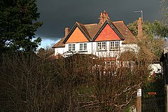
Allhallows College, previously known as Allhallows School, was a British public school for boys in Devon, in the west of England. Predominantly a boarding school, but with some day boys, it was founded in Honiton about 1515, moved to a new home at Rousdon in the 1930s, and was closed in 1998, after a fall in the number of boys had led to a financial crisis.

Combpyne is a village and former civil parish, now in the parish of Combpyne Rousdon, in the East Devon district, in the county of Devon, England. It is off the A3052 road between Colyford and Lyme Regis in Dorset. In 1931 the parish had a population of 83. On 1 April 1939 the parish was abolished to form "Combpyne Rousdon".
Pinhay is a hamlet in the civil parish of Combpyne Rousdon in the East Devon district of Devon, England. The hamlet lies approximately 1.5 miles (2.4 km) south-west from Lyme Regis, its nearest town.

The Axmouth to Lyme Regis Undercliffs, also often referred to in the singular as the Undercliff, is a 5-mile (8.0 km) long landscape feature, National Nature Reserve and Site of Special Scientific Interest that connects Seaton and Axmouth with Lyme Regis on the south-west coast of England. Like its namesake on the Isle of Wight, this feature arose as a result of landslips, where a slump of harder strata over softer clay gave rise to irregular landscapes of peaks, gullies and slipped blocks. Because of the resulting difficulty of access and change of land use, the undercliff has become densely vegetated, and has become a rare and unusual habitat for plants and birds.

Axmouth Old Bridge is a bridge across the River Axe near its mouth on the south coast of the English county of Devon. It effectively links the village of Axmouth with the seaside town of Seaton, although the whole of the Axe estuary, including both banks and hence the bridge, is within the civil parish of Axmouth. It was built in 1877 and closed to vehicles in 1990, although it is still available to pedestrians and forms part of the route of the South West Coast Path. It is now paralleled by a modern road bridge.