Bulverton

Last updated

Bulverton
Old Manor Cottage Bulverton - geograph.org.uk - 1471848.jpg
Cottage in Bulverton (Dark lane)
Devon UK location map.svg
Red pog.svg
Bulverton
Location within Devon
OS grid reference SY119888
Civil parish
  • Sidmouth
District
Shire county
Region
Country England
Sovereign state United Kingdom
Post town SIDMOUTH
Postcode district EX10
Dialling code 01395
Police Devon and Cornwall
Fire Devon and Somerset
Ambulance South Western
UK Parliament
List of places
UK
England
Devon
50°41′31″N3°14′53″W / 50.692°N 3.248°W / 50.692; -3.248

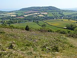
Bulverton is a small hamlet on the outskirts of Sidmouth, Devon, England. In the UK

Contents

Area Information

Bulverton comprises low-density residential housing, areas of farmland and a wooded plantation and is connected by road to Sidmouth by the B3176.

During the Sidmouth Folk Week the area is the location of the Bulverton Late Night Extra. [1]

Since 1963 much of the Bulverton area has fallen under the East Devon Area of Outstanding Natural Beauty: [2]

The East Devon Area of Outstanding Natural Beauty (AONB) landscape is characterised by intimate wooded combes, vast areas of heathland, fertile river valleys and breathtaking cliffs or hilltops. It includes the East Devon section of the Jurassic Coast [3] - England's first natural World Heritage Site - and is a living, working landscape shaped by many centuries of farming activity.

History

At the time of William the Conqueror, the hamlet formed part of the extensive Otterton Manor lands, owned by the monastery of Mont Saint-Michel in Normandy. The Otterton Cartulary, which listed ecclesiastical holdings in the medieval period, records 'Eduart de Boluorton' and Ricard de Boluorton' ploughing ferlings for the Prior. In 1415 Bulverton and other land and possessions of the Otterton Manor passed to the Abbey of Sion in Middlesex. By the reign of Edward IV, Bulverton is listed within the Manor of Sidmouth, but the tenants still owed fealty to the Abbess of Sion. The Manor Court Roll of 1467 recorded that William Goule of Bolferton fell foul of the local assize when he was caught brewing inferior ale by the ale-taster and duly fined. After the Dissolution of the Monasteries, the Manor of Sidmouth, including the farms at Bulverton, passed into private ownership. In the late 18th Century, the Manor of Sidmouth was acquired by Thomas Jenkins, and successive owners expanded the estate. At Bulverton, generations of the same families continued to farm the land as tenants - the Gigg family at Bulverton Farm (now Bulverton House) while the Coles family occupied Bulverton Well Farm. In the early 1950's the two farms, together with other historic cottages in the hamlet, were put up for sale when the Manor estate was dispersed.

The view from Bulverton Hill [4] is thought to have inspired 19th century poet and hymn writer John Keble who was a frequent visitor to Sidmouth. Keble's Seat at Bulverton Hill is named after him and commands a panoramic view of the Lower Otter Valley and Dartmoor in the distance.

Railway

The former Sidmouth Railway station [5] is nearby, with the embankment still visible in certain areas. A proposed cycle route involving Sustrans [6] may use part of the embankment in the future to link outlying towns and villages to Sidmouth.

Climate

The Met Office have a climate station at Sidmouth in the generality of Bulverton that records the comparatively mild United Kingdom climate.

Climate data for Sidmouth Station 1981–2010
MonthJanFebMarAprMayJunJulAugSepOctNovDecYear
Average high °C (°F)8.9
(48.0)
8.8
(47.8)
10.8
(51.4)
12.8
(55.0)
15.9
(60.6)
18.5
(65.3)
20.5
(68.9)
20.5
(68.9)
18.5
(65.3)
15.2
(59.4)
11.9
(53.4)
9.4
(48.9)
14.3
(57.7)
Average low °C (°F)3.3
(37.9)
2.9
(37.2)
4.3
(39.7)
5.3
(41.5)
8.5
(47.3)
11.1
(52.0)
13.2
(55.8)
13.1
(55.6)
11.1
(52.0)
8.8
(47.8)
5.8
(42.4)
3.7
(38.7)
7.6
(45.7)
Average precipitation mm (inches)81.8
(3.22)
62.8
(2.47)
66.9
(2.63)
59.6
(2.35)
55.2
(2.17)
50.4
(1.98)
51.1
(2.01)
58.2
(2.29)
62.5
(2.46)
89.0
(3.50)
84.8
(3.34)
91.7
(3.61)
813.9
(32.04)
Mean monthly sunshine hours 67.784.6119.1168.6191.0197.4213.7198.1145.2110.281.960.11,637.7
Source: Met Office [7]

Related Research Articles

<span class="mw-page-title-main">Axminster</span> Town in Devon, England

Axminster is a market town and civil parish on the eastern border of the county of Devon in England. It is 28 miles (45 km) from the county town of Exeter. The town is built on a hill overlooking the River Axe which heads towards the English Channel at Axmouth, and is in the East Devon local government district. At the 2001 census, it had a population of 5,626, increasing to 5,761 at the 2011 census. The town contains two electoral wards whose combined population is 7,110. The market is still held every Thursday.

<span class="mw-page-title-main">Sidmouth</span> Town in Devon, England

Sidmouth is a town on the English Channel in Devon, South West England, 14 miles (23 km) southeast of Exeter. With a population of 12,569 in 2011, it is a tourist resort and a gateway to the Jurassic Coast World Heritage Site. A large part of the town has been designated a conservation area.

<span class="mw-page-title-main">Budleigh Salterton</span> Town in Devon, England

Budleigh Salterton is a seaside town on the coast in East Devon, England, 15 miles (24 km) south-east of Exeter. It lies within the East Devon Area of Outstanding Natural Beauty, and forms much of the electoral ward of Budleigh, whose ward population at the 2011 census was 5,967.

<span class="mw-page-title-main">Otterton Mill</span> Water mill in Devon, England

Otterton Water Mill is at the village of Otterton, near Budleigh Salterton in Devon, England.

<span class="mw-page-title-main">East Devon</span> Non-metropolitan district in England

<span class="mw-page-title-main">Braunton</span> Village in Devon, England

Braunton is a large village, civil parish, ecclesiastical parish and former manor in Devon. The village is situated 5 miles (8 km) west of Barnstaple. It is one of the largest villages in Devon with a population at the 2021 census of 10,217 people. There are two electoral wards. Their joint population at the above census was 8,218. Within the parish is the fertile, low-lying Braunton Great Field, which adjoins the undulating Braunton Burrows, the Core Area in North Devon Biosphere Reserve, the largest psammosere in England. It confronts the Atlantic Ocean at the west of the parish at the large beach of Saunton Sands, one of the South West's international-standard surfing beaches.

<span class="mw-page-title-main">River Otter, Devon</span> River in Somerset and Devon, England

The River Otter is a river that rises in the Blackdown Hills just inside the county of Somerset, England near Otterford, then flows south through East Devon. It enters the English Channel at the western end of Lyme Bay, part of the Jurassic Coast, a UNESCO World Heritage Site. The Permian and Triassic sandstone aquifer in the Otter Valley is one of Devon's largest groundwater sources, supplying drinking water to 200,000 people.

<span class="mw-page-title-main">Combe Martin</span> Village in Devon, England

Combe Martin is a village, civil parish and former manor on the North Devon coast about 4 miles (6.4 km) east of Ilfracombe. It is a small seaside resort with a sheltered cove on the northwest edge of the Exmoor National Park.

<span class="mw-page-title-main">Berrynarbor</span> Village and civil parish in the North Devon district of Devon, England

Berrynarbor is a village, civil parish and former manor in the North Devon district of Devon, England. According to the 2001 census the parish had a population of 749, increasing to 802 at the 2011 census. The village is located on the north coast of the county to the north of Exmoor, about three miles east of Ilfracombe. The parish is surrounded clockwise from the east by the parishes of Combe Martin, Kentisbury, East Down, Marwood, Bittadon, and Ilfracombe. Berrynarbor has within its purview to all sides a mixture of dense woodlands and farms and lies within the North Devon Area of Outstanding Natural Beauty.

<span class="mw-page-title-main">Branscombe</span> Village in Devon, England

Branscombe is a village in the East Devon district of the English County of Devon.

<span class="mw-page-title-main">Dormansland, Surrey</span> Village in Surrey, England

Dormansland is a large village and civil parish with a low population approximately one mile south of Lingfield in Surrey, England. It was founded in the 19th century and is bordered on the east by the county of Kent and on the south by West Sussex and East Sussex, the only area of the county which borders East Sussex. The nearest town is the small town of East Grinstead, immediately across the West Sussex border.

<span class="mw-page-title-main">Feniton</span> Village in Devon, England

Feniton is a village and civil parish in East Devon in the English county of Devon. The village lies about 4 miles (6.4 km) west of Honiton, 3 miles (4.8 km) north of Ottery St Mary, and 2 miles (3.2 km) east of Talaton.

<span class="mw-page-title-main">Tamar Valley AONB</span>

Tamar Valley Area of Outstanding Natural Beauty or Tamar Valley AONB is a legally designated Area of Outstanding Natural Beauty in Devon and Cornwall in England.

<span class="mw-page-title-main">Otterton</span> Village in Devon, England

Otterton is a village and civil parish in East Devon, England. The parish lies on the English Channel and is surrounded clockwise from the south by the parishes of East Budleigh, Bicton, Colaton Raleigh, Newton Poppleford and Harpford and Sidmouth. In 2001 its population was 700, compared to 622 a hundred years earlier. At the 2011 census the population had reduced to 656. Otterton is part of Raleigh electoral ward whose total population at the above census was 2,120.

<span class="mw-page-title-main">Salcombe Regis</span> Village in Devon, England

Salcombe Regis is a coastal village and former civil parish, now in the parish of Sidmouth, in the East Devon district, in the county of Devon, England. Mentioned in the Domesday Book as "a manor called Selcoma" held by Osbern FitzOsbern, bishop of Exeter, the manor house stood on the site now occupied by Thorn Farm. The thorn tree growing in an enclosure at the road junction above the farm marked the cultivation boundary between manor and common ground. In 1951 the parish had a population of 869. On 1 April 1974 the parish was abolished and merged with Sidmouth.

<span class="mw-page-title-main">Danger Point</span> Cliff face in Devon, England

Danger Point is a coastal feature and cliff face in Devon, on the south coast of England. It is about 18 kilometres (11 mi) southeast of the city of Exeter and about 7 kilometres (4.3 mi) east of Exmouth and lies between the towns of Budleigh Salterton and Sidmouth.

<span class="mw-page-title-main">Yarcombe</span> Village in Devon, England

Yarcombe is a village and civil parish in the county of Devon, England, situated in the East Devon administrative district on the A30 road near the towns of Honiton and Chard. It is sited in the steep rolling meadows and ancient woods of the Yarty Valley on the south edge of the Blackdown Hills, an Area of Outstanding Natural Beauty. The population according to the 2011 census was 500.

<span class="mw-page-title-main">Chivelstone</span> Village in Devon, England

Chivelstone is a village and civil parish in Devon, England. The parish contains the villages of East Prawle and South Allington as well as the hamlets of Ford and Lannacombe. The population of the parish taken at the 2011 census was 280.

<span class="mw-page-title-main">Manor of Otterton</span>

The Manor of Otterton was a medieval manor in East Devon, England.

References

  1. "Sidmouth Folk Week – August 4th – 11th 2017".
  2. "East Devon Area of Outstanding Natural Beauty - Welcome - East Devon Area of Outstanding Natural Beauty".
  3. "The Jurassic Coast World Heritage Site". Jurassic Coast World Heritage Site.
  4. "Bulverton Hill". www.hill-bagging.co.uk.
  5. "Disused Stations: Sidmouth Station". www.disused-stations.org.uk.
  6. "Archived copy" (PDF). Archived from the original (PDF) on 24 September 2015. Retrieved 31 March 2015.{{cite web}}: CS1 maint: archived copy as title (link)
  7. Office, Met. "Sidmouth climate". www.metoffice.gov.uk.
  8. "Poet's favourite coastal vantage point is celebrated by East Devon estate owners". 11 March 2014.[ permanent dead link ]