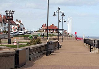
Hornsea is a seaside town and civil parish in the East Riding of Yorkshire, England. The settlement dates to at least the early medieval period. The town was expanded in the Victorian era with the coming of the Hull and Hornsea Railway in 1864. In the First World War, the mere was briefly the site of RNAS Hornsea Mere, a seaplane base. During the Second World War, the town and beach were heavily fortified against invasion.

Durdle Door is a natural limestone arch on the Jurassic Coast near Lulworth in Dorset, England. It is privately owned by the Weld family, who own the Lulworth Estate, but it is also open to the public.

Portland Harbour is beside the Isle of Portland, Dorset, on the south coast of England. Construction of the harbour began in 1849; when completed in 1872, its 520-hectare (1,300-acre) surface area made it the largest human-made harbour in the world, and it remains one of the largest in the world today. It is naturally sheltered by Portland to the south, Chesil Beach to the west and mainland Dorset to the north. It consists of four breakwaters: two southern and two northern. These have a total length of 4.57 km (2.84 mi) and enclose approximately 1,000 ha of water.

Wakeham is a hamlet near the village of Easton, in Tophill on the Isle of Portland in Dorset, England. It is situated between the Straits part of Easton, and Pennsylvania Castle. As with the rest of Portland's villages and settlements, Wakeham has been designated as a conservation area, as it is a place of special architectural and historic interest. Easton, Wakeham and Reforne were designated pre-1974. The hamlet features a distinctively wide road running through it, once built to allow space for horse-drawn carts transporting stone by road. Many of Wakeham's older buildings of the 17th and 18th century survive.

Castletown is a small village in Underhill on the Isle of Portland in Dorset. It is located close to Fortuneswell, on the shores of Portland Harbour, and includes a sandy beach, as well as one of Portland's notable highlights; Portland Castle, while the Weymouth and Portland National Sailing Academy is also located nearby.

Southwell is a small coastal village in Tophill on the Isle of Portland, Dorset. As Portland and Dorset's southernmost village, it lies between Portland Bill and the villages of Easton and Weston. Though close to the Bill, the village is sheltered by hills on three sides. It is the only village on Portland not to be designated a conservation area.

Church Ope Cove is a small secluded beach on the sheltered eastern side of the Isle of Portland in Dorset, southern England, and is part of the Jurassic Coast. It is found close to the village of Wakeham. The beach has many unusual features for the Isle of Portland. The beach used to be sandy, but quarry debris now covers the sand, and has been worn into rounded pebbles. The pebbles cover a small stream which runs to the sea, which is one of the few active streams remaining on the Isle of Portland.

White Nothe is a chalk headland on the English Channel coast at the eastern end of Ringstead Bay, east of Weymouth in Dorset, England. The area is well known for its geology and fossils. Its flanks are the result of prehistoric landslides and the inaccessible slopes of the undercliff provide a secluded wildlife habitat.
Balaclava Bay is a bay situated on the edge of Portland Harbour, where the breakwater meets the island, at the northern end of the Isle of Portland, Dorset, in southern England. The bay is overlooked by the Victorian East Weare Battery, built in the 1860s to protect the harbour. The nearest road within the dockyard of Portland Port is named Balaclava Road.

Nothe Gardens is a public garden, located in Weymouth, Dorset, England. Positioned on the Nothe Peninsula overlooking both Weymouth and Portland harbours, the informal gardens are often acclaimed to be the most beautiful the borough has to offer.
The Portland Windmills are two disused stone towers which were used as windmills from at least the early 17th century. They are located on the Isle of Portland south of Easton village and the east of Weston village. The towers, which are relatively short mills with conical caps, stand approximately 135 metres apart. They have been separate Grade II Listed monuments since September 1978, and are the only historic windmill remains to survive in Dorset.

King Barrow Quarry is a disused site of former 19th century stone quarries on the Isle of Portland, Dorset, England. It is located in the north-east corner of Tophill. The quarry, now a Dorset Wildlife Trust nature reserve, covers 12.2 hectares. Both King Barrow and the nearby Tout Quarry make up the Dorset Wildlife Trust's Portland Quarries Nature Park. Portland also has two butterfly reserves: Broadcroft Quarry and Perryfield Quarry.

Mutton Cove is a cove, located on the Isle of Portland, Dorset, England; part of the Jurassic Coast. It is found on the west side of Portland. Presumably named after the once-famous Portland sheep, the cove is an erosional indentation just south of the promontory of Blacknor. On the cliff tops of the cove is part of the South West Coast Path and further south is Wallsend Cove and Portland Bill.
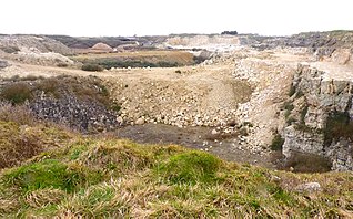
Jurassica was a planned visitor attraction in a disused quarry on the Isle of Portland, near Weymouth in Dorset, southern England. It was based on the Jurassic Coast, a World Heritage Site, and as a subterranean geological park, would have largely presented the prehistoric world. The attraction's location was chosen as Yeolands Quarry, a now disused quarry that was operational until the 21st century by Portland Stone Ltd. The quarry is 36 metres (120 ft) deep, 90 metres (300 ft) wide, and is on the eastern side of the island just south of The Grove village.

Red Crane is a crane on the Isle of Portland, Dorset, England. It is located on the cliff edge at Portland's southerly point, the promontory Portland Bill. It is part of a disused stone loading quay, which is now a scheduled monument.

King's Pier is a 17th-century stone shipping quay, located on the Isle of Portland, Dorset, England; part of the Jurassic Coast. It is found at the boundary point of the land owned by Portland Port Ltd, on the east side of the island within the area of East Weares. To the north of the pier is Balaclava Bay, whilst further south along the coastline are the remains of Folly Pier and Folly Pier Waterworks, East Weare Rifle Range, the two Salt Pans, Little Beach and Durdle Pier respectively. When active, King's Pier was one of the most important stone shipping pier sites.

Folly Pier is a disused stone shipping quay, located on the Isle of Portland, Dorset, England; part of the Jurassic Coast. It is found on the east side of the island within the area of East Weares. Other piers within the area include King's Pier and Durdle Pier respectively. Folly Pier dates from the 17th century.

East Weare Rifle Range is a disused naval rifle range on the Isle of Portland, Dorset, England. It is located within the area of East Weares, overlooking Portland Harbour. The range became a scheduled monument in October 2015, which included the stop butt of Portland stone, the marker's gallery and 100-yard firing position. It remains on the private property of Portland Port Ltd, and has not been opened to the public, however can be seen from surrounding coastal paths.

Merchant's Railway was a horse drawn and cable operated incline railway on the Isle of Portland, Dorset, England, built for the stone trade on the island. It was the earliest railway in Dorset, opening in 1826. The railway ran two miles from many working quarries at the north of Tophill, along the edge of Verne Hill, to a pier at Castletown, from where the Portland stone was shipped. It was in operation from 1826 to 1939. Since becoming disused the original path of the railway has become a popular public footpath.
Yeolands Quarry is a disused stone quarry located on the Isle of Portland, Dorset, England. It is located on the eastern side of Portland, where it lies east of the village Easton and south of The Grove village. The quarry is one of the largest on Portland, at 120 feet (37 m) deep, 300 feet (91 m) wide. It is now abandoned for extracting stone, though the adjacent Broadcroft Quarry to the west, which links to Yeolands, is still in some use, as well as being a butterfly reserve.


