
Portland stone is a limestone geological formation dating to the Tithonian age of the Late Jurassic that is quarried on the Isle of Portland in Dorset, England. The quarries are cut in beds of white-grey limestone separated by chert beds. It has been used extensively as a building stone throughout the British Isles, notably in major public buildings in London such as St Paul's Cathedral and Buckingham Palace. Portland stone is also exported to many countries, being used for example at the United Nations headquarters in New York City.

The Isle of Portland is a tied island, 6 kilometres (4 mi) long by 2.7 kilometres (1.7 mi) wide, in the English Channel. The southern tip, Portland Bill lies 8 kilometres (5 mi) south of the resort of Weymouth, forming the southernmost point of the county of Dorset, England. A barrier beach called Chesil Beach joins Portland with mainland England. The A354 road passes down the Portland end of the beach and then over the Fleet Lagoon by bridge to the mainland. The population of Portland is 13,417.

Wakeham is a hamlet near the village of Easton, in Tophill on the Isle of Portland in Dorset, England. It is situated between the Straits part of Easton, and Pennsylvania Castle. As with the rest of Portland's villages and settlements, Wakeham has been designated as a conservation area, as it is a place of special architectural and historic interest. Easton, Wakeham and Reforne were designated pre-1974. The hamlet features a distinctively wide road running through it, once built to allow space for horse-drawn carts transporting stone by road. Many of Wakeham's older buildings of the 17th and 18th century survive.

Tophill is a gently sloping area of land on the Isle of Portland in Dorset, England, rising from sea level at Portland Bill to 151 metres (495 ft) near HMP The Verne at its northern end. On Tophill are five of the settlements on the island: Easton, Weston, Southwell, the Grove and Wakeham. Portland stone lies under Tophill, and the strata decline at a shallow angle of around 1.5 degrees from their peak down to sea level. The lower northern end of the island is called Underhill.

Southwell is a small coastal village in Tophill on the Isle of Portland, Dorset. As Portland and Dorset's southernmost village, it lies between Portland Bill and the villages of Easton and Weston. Though close to the Bill, the village is sheltered by hills on three sides. It is the only village on Portland not to be designated a conservation area.

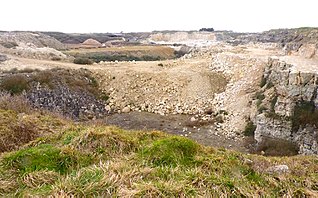
Bowers Quarry/Mine is an active stone quarry on the west side of the Isle of Portland, Dorset, England. The quarry is operated by Albion Stone and became the site of the first Portland Stone mine. In October 2002 the firm successfully initiated Portland's first ever underground mining operation, which was a precursor to Jordans Mine, which would start in 2008. It has also been the selected site for the planned Mass Extinction Memorial Observatory.
There are eight settlements on the Isle of Portland, Dorset, England, the largest of which are Fortuneswell in Underhill and Easton on Tophill. The other villages of Weston, Southwell, Wakeham and the Grove also occupy Tophill, and Castletown and Chiswell are the other villages in Underhill.

Durdle Pier is a disused 17th-century stone shipping quay, located on the Isle of Portland, Dorset, England; part of the Jurassic Coast. It is found close by Yeolands Quarry, on the east side of the island within the area of East Weares and Penn's Weare.

Broadcroft Quarry is an active stone quarry and part butterfly nature reserve located on the Isle of Portland, Dorset, England. It is located towards the eastern side of the island, where it lies to the east of the village Easton and close to The Grove village. The reserve section is now a valued home for a number of butterfly species, while the working quarry area is one of the largest active quarries on Portland and has supplied London with natural Portland stone for many years. The quarry is owned by Portland Stone Firms Ltd, along with Perryfield and Coombefield Quarries. The firm is the largest landholder on the island. The nature reserve is managed by Butterfly Conservation.

Culverwell Mesolithic Site is a Mesolithic settlement, located on the Isle of Portland, Dorset, England. It is found in the local area known as Culverwell, along the Portland Bill Road. It is within an area of unspoiled countryside, with no past quarrying. The site is maintained by the Association for Portland Archaeology – a small group dedicated to researching, investigating and excavating on Portland.

The Great Southwell Landslip occurred in 1734 on the Isle of Portland, Dorset, England near the southerly village of Southwell and extended for a length of 1.5 miles (2.4 km) between Durdle Pier and Freshwater Bay. It remains Britain's second largest recorded historical landslide.
Jurassica was a planned visitor attraction in a disused quarry on the Isle of Portland, near Weymouth in Dorset, southern England. It was based on the Jurassic Coast, a World Heritage Site, and as a subterranean geological park, would have largely presented the prehistoric world. The attraction's location was chosen as Yeolands Quarry, a now disused quarry that was operational until the 21st century by Portland Stone Ltd. The quarry is 36 metres (120 ft) deep, 90 metres (300 ft) wide, and is on the eastern side of the island just south of The Grove village.

Grove Lime Kiln is a disused 19th century lime kiln on the Isle of Portland, Dorset, England. It is located close to HM Prison Portland and The Grove village. Owned by the prison service, the lime kiln has been Grade II Listed since 2009.

Southwell Business Park is a business park on the Isle of Portland, Dorset, England. It is housed at the former Admiralty Underwater Weapons Establishment, which closed in 1995 and became the Southwell Business Park in 1997.

Southwell Methodist Chapel is a former Methodist chapel at Southwell, on the Isle of Portland, Dorset, England. The chapel was built in 1849 between terraced cottages on the east side of the road leading from Southwell to Portland Bill. It closed in 1997 and is now a private residence. It has been Grade II Listed since May 1993.
Yeolands Quarry is a disused stone quarry located on the Isle of Portland, Dorset, England. It is located on the eastern side of Portland, where it lies east of the village Easton and south of The Grove village. The quarry is one of the largest on Portland, at 120 feet (37 m) deep, 300 feet (91 m) wide. It is now abandoned for extracting stone, though the adjacent Broadcroft Quarry to the west, which links to Yeolands, is still in some use, as well as being a butterfly reserve.

Perryfield Quarry is an operational stone quarry and part butterfly nature reserve located on the Isle of Portland, Dorset, England. It is situated towards the middle of the island, east of the village of Weston and south of the hamlet of Wakeham. The reserve section is now a valued home for a number of butterfly species, while the working quarry area is one of the largest active quarries on Portland. The quarry is owned by Portland Stone Firms Ltd, along with Broadcroft and Coombefield Quarries. The firm is the largest landholder on the island.

Stonehills Mine is the first completely new mine on Portland. Albion Stone Plc began the process to open this mine began in 2015 and reserves are estimated to last for 50 years (2066). The planning application to begin work on Stonehills was submitted to the Dorset County Council in February 2001 and was finally approved in February 2005. The site is owned by the Crown Estate and the leased by Albion Stone plc who extract Portland Stone Whitbed and Portland Stone Basebed. Albion Stone Plc use room and pillar mining method of extraction which is already being carried out in their Jordans mine and Bowers Mine.


