Tout Quarry

Last updated

Part of Tout Quarry's landscape Isle of Portland Tout Quarry Landscape.jpg
Part of Tout Quarry's landscape

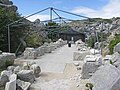
Tout Quarry, now known as Tout Quarry Sculpture Park and Nature Reserve, is a sculpture park and nature reserve based within a disused quarry on the Isle of Portland, Dorset, England. It is located within the north-west corner of Tophill. The sculpture park has existed since 1983, while the site also become a nature reserve around 2004. To date, the quarry displays a collection of various carvings and works in Portland stone. [1] [2]

Contents

Background

Tout Quarry was worked commercially during the 18th and 19th-centuries. The quarry was last worked in 1982 for a boulder contract when 30,000 tons were excavated for sea defenses. Portland Sculpture & Quarry Trust began the sculpture park in 1983, saving the quarry from further mineral extraction with the creation of sculptures, and the park officially opened in that year. Many of the original site specific sculptures can still be discovered today, although some didn't last much longer than a year. [1] [3]

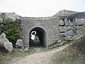
In places around the quarry, there are numerous ravines leading to the cliff edge. Tramway lines once ran throughout the quarry, taking stone waste to the cliff edge to be tipped or taking block stone to Priory Corner where it was transported along the Merchant's Railway to Castletown, from where it as shipped across the world. [1] The Grade II Listed Lano's Bridge was built in the mid-1800s to carry a high level tramway taking stone waste to the cliff edge. [1] [4]

Portland Sculpture and Quarry Trust

The Portland Sculpture and Quarry Trust was formed in 1983 when the quarry was turned into a park. [5] The trust is dedicated to "preserving a knowledge and understanding of all aspects of stone and the landscape from which it comes". It operates within the quarry and at its headquarters at the nearby Drill Hall. An outdoor workshop is located within the quarry and is used to run courses from May to September each year. [6] The yearly programme of stone carving and sculpture courses teaches skills in stone carving direct carving, lettercutting, relief carving and architectural detail. The indoor workspace at the Drill Hall is also used for this purpose.

In 2008, the Trust was the runner-up in the British Urban Regeneration Association's awards for community-inspired regeneration. [7] In 2009, the Trust was shortlisted for the British Urban Regeneration Awards Scheme. [8]

Sculptures

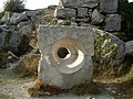
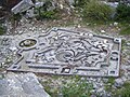
There is estimated to be over 70 different sculptures within the quarry. [9] These include:

See also

Related Research Articles

<span class="mw-page-title-main">Portland stone</span> Limestone quarried on the Isle of Portland, Dorset, England

Portland stone is a limestone geological formation dating to the Tithonian age of the Late Jurassic that is quarried on the Isle of Portland in Dorset, England. The quarries are cut in beds of white-grey limestone separated by chert beds. It has been used extensively as a building stone throughout the British Isles, notably in major public buildings in London such as St Paul's Cathedral and Buckingham Palace. Portland stone is also exported to many countries, being used for example at the United Nations headquarters in New York City.

<span class="mw-page-title-main">Isle of Purbeck</span> Peninsula in Dorset, England

The Isle of Purbeck is a peninsula in Dorset, England. It is bordered by water on three sides: the English Channel to the south and east, where steep cliffs fall to the sea; and by the marshy lands of the River Frome and Poole Harbour to the north. Its western boundary is less well defined, with some medieval sources placing it at Flower's Barrow above Worbarrow Bay. John Hutchins, author of The History and Antiquities of the County of Dorset, defined Purbeck's western boundary as the Luckford Lake steam, which runs south from the Frome. According to writer and broadcaster Ralph Wightman, Purbeck "is only an island if you accept the barren heaths between Arish Mell and Wareham as cutting off this corner of Dorset as effectively as the sea." The most southerly point is St Alban's Head.

<span class="mw-page-title-main">Seaton, Devon</span> Town in Devon, England

Seaton is a seaside town, fishing harbour and civil parish in East Devon on the south coast of England, between Axmouth and Beer. It faces onto Lyme Bay and is on the Dorset and East Devon Coast Jurassic Coast World Heritage Site. A sea wall provides access to the mostly shingle beach stretching for about a mile, and a small harbour, located mainly in the Axmouth area.

<span class="mw-page-title-main">Tophill</span>

Tophill is a gently sloping area of land on the Isle of Portland in Dorset, England, rising from sea level at Portland Bill to 151 metres (495 ft) near HMP The Verne at its northern end. On Tophill are five of the settlements on the island: Easton, Weston, Southwell, the Grove and Wakeham. Portland stone lies under Tophill, and the strata decline at a shallow angle of around 1.5 degrees from their peak down to sea level. The lower northern end of the island is called Underhill.

Weston is a village in Tophill on the Isle of Portland, Dorset, England. It abuts the main village Easton. As with the rest of Portland's villages and settlements, Weston has been designated as a conservation area, as it is a place of special architectural and historic interest. The village was designated in 1994.

<span class="mw-page-title-main">Castletown, Dorset</span> Village in Dorset, England

Castletown is a small village in Underhill on the Isle of Portland in Dorset. It is located close to Fortuneswell, on the shores of Portland Harbour, and includes a sandy beach, as well as one of Portland's notable highlights; Portland Castle, while the Weymouth and Portland National Sailing Academy is also located nearby.

<span class="mw-page-title-main">Bowers Quarry</span> Quarry in Dorset, England

Bowers Quarry/Mine is an active stone quarry on the west side of the Isle of Portland, Dorset, England. The quarry is operated by Albion Stone and became the site of the first Portland Stone mine. In October 2002 the firm successfully initiated Portland's first ever underground mining operation, which was a precursor to Jordans Mine, which would start in 2008. It has also been the selected site for the planned Mass Extinction Memorial Observatory.

West Park is an affluent residential area at the North West fringe of Darlington, County Durham, England.

<span class="mw-page-title-main">The Grove, Portland</span> Human settlement in England

The Grove is a small village located at Tophill on the Isle of Portland in Dorset. The village is found close to the larger village Easton, and is most notable for containing the HM Prison Portland, including its museum Grove Prison Museum. As with the rest of Portland's villages and settlements, The Grove has been designated as a conservation area, as it is a place of special architectural and historic interest. The village was designated in 1981.

<span class="mw-page-title-main">Hallelujah Bay</span> Bay in United Kingdom

Hallelujah Bay is a bay located on the west side of the Isle of Portland, Dorset, England. The bay is situated below West Weares, with Clay Ope, Blacknor Point and Mutton Cove further south. Near the cove is a large mound of rock and earth beneath the clifftops known locally as the Green Hump.

<span class="mw-page-title-main">Nicodemus Knob</span>

Nicodemus Knob is a 30-feet pillar of Portland stone, left as a landmark and quarrying relic at East Cliff on the Isle of Portland, Dorset, England. A similar artificial pillar formed through quarrying is Pulpit Rock at Portland Bill.

<span class="mw-page-title-main">King Barrow Quarry</span> Disused quarry site

King Barrow Quarry is a disused site of former 19th century stone quarries on the Isle of Portland, Dorset, England. It is located in the north-east corner of Tophill. The quarry, now a Dorset Wildlife Trust nature reserve, covers 12.2 hectares. Both King Barrow and the nearby Tout Quarry make up the Dorset Wildlife Trust's Portland Quarries Nature Park. Portland also has two butterfly reserves: Broadcroft Quarry and Perryfield Quarry.

<span class="mw-page-title-main">Broadcroft Quarry</span> Quarry in Dorset, England

Broadcroft Quarry is an active stone quarry and part butterfly nature reserve located on the Isle of Portland, Dorset, England. It is located towards the eastern side of the island, where it lies to the east of the village Easton and close to The Grove village. The reserve section is now a valued home for a number of butterfly species, while the working quarry area is one of the largest active quarries on Portland and has supplied London with natural Portland stone for many years. The quarry is owned by Portland Stone Firms Ltd, along with Perryfield and Coombefield Quarries. The firm is the largest landholder on the island. The nature reserve is managed by Butterfly Conservation.

<span class="mw-page-title-main">Great Southwell Landslip</span>

The Great Southwell Landslip occurred in 1734 on the Isle of Portland, Dorset, England near the southerly village of Southwell and extended for a length of 1.5 miles (2.4 km) between Durdle Pier and Freshwater Bay. It remains Britain's second largest recorded historical landslide.

<span class="mw-page-title-main">Jurassica</span> Inactive Pre Historical Attraction

Jurassica was a planned visitor attraction in a disused quarry on the Isle of Portland, near Weymouth in Dorset, southern England. It was based on the Jurassic Coast, a World Heritage Site, and as a subterranean geological park, would have largely presented the prehistoric world. The attraction's location was chosen as Yeolands Quarry, a now disused quarry that was operational until the 21st century by Portland Stone Ltd. The quarry is 36 metres (120 ft) deep, 90 metres (300 ft) wide, and is on the eastern side of the island just south of The Grove village.

<span class="mw-page-title-main">Perryfield Quarry</span> Stone quarry in Dorset, England

Perryfield Quarry is an operational stone quarry and part butterfly nature reserve located on the Isle of Portland, Dorset, England. It is situated towards the middle of the island, east of the village of Weston and south of the hamlet of Wakeham. The reserve section is now a valued home for a number of butterfly species, while the working quarry area is one of the largest active quarries on Portland. The quarry is owned by Portland Stone Firms Ltd, along with Broadcroft and Coombefield Quarries. The firm is the largest landholder on the island.

<span class="mw-page-title-main">Coombefield Quarry</span> Stone quarry located on the Isle of Portland, Dorset, England

Coombefield Quarry is an active stone quarry located on the Isle of Portland, Dorset, England. It is situated near the island's southernmost village Southwell. The large quarry has been worked over many years, and has two voids known as Coombefield North and Coombefield South. The quarry today incorporates the former Suckthumb Quarry, which is situated at the northwest part of the quarry, and is now filled in. The quarry is owned by Portland Stone Firms Ltd, along with Broadcroft and Perryfield Quarry. The firm is the largest landholder on the island.

References

  1. 1 2 3 4 "Tout Quarry and Sculpture Park, Portland, Dorset". Geoffkirby.co.uk. Retrieved 8 June 2012.
  2. "Tout Quarry Map | General". Learningstone.org. Retrieved 8 June 2012.
  3. "Portland Sculpture & Quarry Trust - History | General". Learningstone.org. Retrieved 8 June 2012.
  4. Historic England. "Details from listed building database (1281839)". National Heritage List for England . Retrieved 22 January 2013.
  5. "Archived copy". Archived from the original on 6 October 2015. Retrieved 8 June 2012.{{cite web}}: CS1 maint: archived copy as title (link)
  6. "Tout Quarry Portland Sculpture Trust & Stone Carving on Portland". Visitweymouth.co.uk. Retrieved 8 June 2012.
  7. "Set in stone | Placemaking Resource". Regen.net. 27 July 2009. Retrieved 23 October 2017.
  8. Swinney, Hilda (29 January 2009). "Portland quarry trust up for award (From Dorset Echo)". Dorsetecho.co.uk. Retrieved 8 June 2012.
  9. "Archived copy". Archived from the original on 13 October 2014. Retrieved 8 June 2012.{{cite web}}: CS1 maint: archived copy as title (link)

Coordinates: 50°33′11″N2°26′41″W / 50.5531°N 2.4446°W / 50.5531; -2.4446