
The Isle of Portland is a tied island, 6 kilometres (4 mi) long by 2.7 kilometres (1.7 mi) wide, in the English Channel. The southern tip, Portland Bill lies 8 kilometres (5 mi) south of the resort of Weymouth, forming the southernmost point of the county of Dorset, England. A barrier beach called Chesil Beach joins it to the mainland. The A354 road passes down the Portland end of the beach and then over the Fleet Lagoon by bridge to the mainland. The population of Portland is 12,797.

Kimmeridge is a small village and civil parish on the Isle of Purbeck, a peninsula on the English Channel coast in Dorset, England. It is situated about 4.5 miles (7.2 km) south of Wareham and 7 miles (11 km) west of Swanage. In 2013 the estimated population of the civil parish was 90.

The Isle of Purbeck is a peninsula in Dorset, England. It is bordered by water on three sides: the English Channel to the south and east, where steep cliffs fall to the sea; and by the marshy lands of the River Frome and Poole Harbour to the north. Its western boundary is less well defined, with some medieval sources placing it at Flower's Barrow above Worbarrow Bay. According to writer and broadcaster Ralph Wightman, Purbeck "is only an island if you accept the barren heaths between Arish Mell and Wareham as cutting off this corner of Dorset as effectively as the sea." The most southerly point is St Alban's Head.
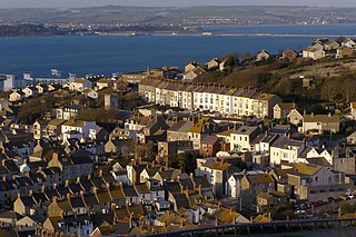
Fortuneswell is a village in Underhill on the Isle of Portland, in Dorset, England. It lies on steeply sloping land on the northern edge of the island, known as Underhill, where Chesil Beach connects the island to the mainland. Adjoining Fortuneswell are Chiswell to the west and Castletown to the north. Fortuneswell occupies the steeper land above sea level, whereas Chiswell and Castletown occupy flat land close to sea level, next to Chesil Beach and Portland Harbour respectively. Fortuneswell has a main shopping street, and along with Easton, is the main hub of the island's activities.
Tophill is a gently sloping area of land on the Isle of Portland in Dorset, England, rising from sea level at Portland Bill to 151 metres (495 ft) near HMP The Verne at its northern end. On Tophill are five of the settlements on the island: Easton, Weston, Southwell, the Grove and Wakeham. Portland stone lies under Tophill, and the strata decline at a shallow angle of around 1.5 degrees from their peak down to sea level. The lower northern end of the island is called Underhill.
There are eight settlements on the Isle of Portland, Dorset, England, the largest of which are Fortuneswell in Underhill and Easton on Tophill. The other villages of Weston, Southwell, Wakeham and the Grove also occupy Tophill, and Castletown and Chiswell are the other villages in Underhill.

Kimmeridge Bay is a bay on the Isle of Purbeck, a peninsula on the English Channel coast in Dorset, England, close to and southeast of the village of Kimmeridge, on the Smedmore Estate. The area is renowned for its fossils, with The Etches Collection in the village of Kimmeridge displaying fossils found by Steve Etches in the area over a 30-year period. It is a popular place to access the coast for tourists. To the east are the Kimmeridge Ledges, where fossils can be found in the flat clay beds.
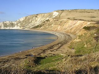
Flower’s Barrow is an Iron Age hillfort, built over 2500 years ago, above Worbarrow Bay in Dorset on the south coast of England.

Gad Cliff is a south-facing cliff face, immediately to the east of Worbarrow Tout and Pondfield Cove, on the south coast of the Isle of Purbeck in Dorset, England. Behind it is Gold Down, part of the Lulworth Ranges.

Clay Ope is on the west side of the Isle of Portland in Dorset, England. It forms part of the Jurassic Coast. The geology of the area includes Purbeck Beds, Portland Stone, Portland Sand, and Kimmeridge Clay. Above Clay Ope is West Cliff.

Brandy Bay is a small secluded southwest-facing bay, with an oil shale and shingle beach immediately below Gad Cliff and Tyneham Cap, to the east of Worbarrow Bay and to the west of Hobarrow Bay on the south coast of the Isle of Purbeck, in Dorset, England.

The Kimmeridge Oil Field is to the northwest of Kimmeridge Bay, on the south coast of the Isle of Purbeck, in Dorset, England.

Dorset is a county located in the middle of the south coast of England. It lies between the latitudes 50.512°N and 51.081°N and the longitudes 1.682°W and 2.958°W, and occupies an area of 2,653 km². It spans 90 kilometres (56 mi) from east to west and 63 kilometres (39 mi) from north to south.

The Portland Cenotaph is a war memorial located on the Isle of Portland, Dorset, England. It is situated at New Ground, looking down to Underhill of the island and overlooking Chesil Beach, as it sits in front of Portland Heights Hotel. The monument is dedicated to the local soldiers who died during both the First and Second World Wars. It has been a Grade II Listed Monument since May 1993.

St George's Centre is a former school, built in the 19th century, and now a community information and activity centre on the Isle of Portland, Dorset, England. It is located in the area of Reforne, near the village of Easton. Both the centre and its community hall, which was formerly the school assembly hall, have been a Grade II listed since 1978.

The Great Southwell Landslip occurred in 1734 on the Isle of Portland, Dorset, England near the southerly village of Southwell and extended for a length of 1.5 miles (2.4 km) between Durdle Pier and Freshwater Bay. It remains Britain's second largest recorded historical landslide.

The Salt Pans are two salt pans on the Isle of Portland, Dorset, England. Both pans sit next to one another, and are situated on the coastline of East Weares, the east side of Portland. The pans sit directly below the Young Offenders Institution HM Prison Portland, and are found close to various old historic relics such as the East Weare Rifle Range, Folly Pier, King's Pier and the remains of the Folly Pier Waterworks. The East Weares area, including the Salt Pans, has been labelled a Site of Special Scientific Interest (SSSI), largely due to the scrub and wildlife being of high nature conservation value.

Underhill Methodist Church is a Methodist Church, opened in 1899, located in Fortuneswell, on the Isle of Portland, Dorset. It was built between 1898–1899, replacing a 1793 chapel built by Robert Carr Brackenbury, the founder of Methodism on Portland. The church remains active to date, as part of the Portland Methodist Circuit, alongside Easton Methodist Church.

Easton Methodist Church is a Methodist Church in Easton, on the Isle of Portland, Dorset, which was built in 1906–07. The church, along with its former manse and boundary walls, has been a Grade II* Listed since May 1993. Its church hall was formerly a Wesleyan school, dated 1878 on the porch. The school, with the boundary wall, was designated Grade II in May 1993. The church remains active to date, as part of the Portland Methodist Circuit – which involves two churches; Underhill Methodist Church and Easton Methodist Church.

The Bridport Sand Formation is a formation of Toarcian age found in the Worcester and Wessex Basins of central and southern England. It forms one of the reservoir units in the Wytch Farm oilfield in Dorset. The sandstone is very-fine grained to fine-grained and contains regular narrow bands that are calcite-cemented and more resistant to weathering, giving it a characteristic banded appearance at outcrop, such as in the cliffs between Bridport and Burton Bradstock in Dorset. It is named for Bridport and has previously been known as the Midford Sand(s), Cotteswold Sands, Yeovil Sands and Upper Lias Sand(s). It forms a locally important aquifer, particularly around Yeovil.
