
The Isle of Portland is a tied island, 6 kilometres (4 mi) long by 2.7 kilometres (1.7 mi) wide, in the English Channel. The southern tip, Portland Bill, lies 8 kilometres (5 mi) south of the resort of Weymouth, forming the southernmost point of the county of Dorset, England. A barrier beach called Chesil Beach joins Portland with mainland England. The A354 road passes down the Portland end of the beach and then over the Fleet Lagoon by bridge to the mainland. The population of Portland is 13,417.

Portland Harbour is beside the Isle of Portland, Dorset, on the south coast of England. Construction of the harbour began in 1849; when completed in 1872, its 520-hectare (1,300-acre) surface area made it the largest human-made harbour in the world, and it remains one of the largest in the world today. It is naturally sheltered by Portland to the south, Chesil Beach to the west and mainland Dorset to the north. It consists of four breakwaters: two southern and two northern. These have a total length of 4.57 km (2.84 mi) and enclose approximately 1,000 ha of water.
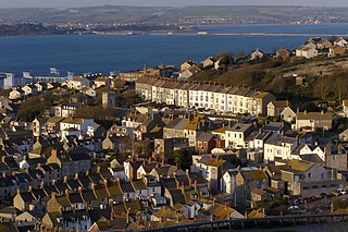
Fortuneswell is a village in Underhill on the Isle of Portland, in Dorset, England. It lies on steeply sloping land on the northern edge of the island, known as Underhill, where Chesil Beach connects the island to the mainland. Adjoining Fortuneswell are Chiswell to the west and Castletown to the north. Fortuneswell occupies the steeper land above sea level, whereas Chiswell and Castletown occupy flat land close to sea level, next to Chesil Beach and Portland Harbour respectively. Fortuneswell has a main shopping street, and along with Easton, is the main hub of the island's activities.

The River Wey is a chalk stream flowing through Dorset in south west England.

Southwell is a small coastal village in Tophill on the Isle of Portland, Dorset. As Portland and Dorset's southernmost village, it lies between Portland Bill and the villages of Easton and Weston. Though close to the Bill, the village is sheltered by hills on three sides. It is the only village on Portland not to be designated a conservation area.
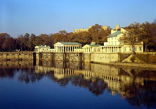
The Fairmount Water Works in Philadelphia, Pennsylvania, was Philadelphia's second municipal waterworks. Designed in 1812 by Frederick Graff and built between 1812 and 1872, it operated until 1909, winning praise for its design and becoming a popular tourist attraction. It now houses a restaurant and an interpretive center that explains the waterworks' purpose and local watershed history. It was designated a National Historic Landmark in 1976 for its architecture and its engineering innovations. It was the nation's first water supply to use paddle wheels to move water.
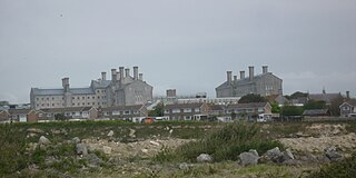
HM Prison Portland is a male Adult/Young Offenders Institution in the village of The Grove on the Isle of Portland, in Dorset, England. It is operated by His Majesty's Prison Service. The prison was originally opened in 1848 as an adult convict establishment, before becoming a Borstal in 1921, and a YOI in 1988. In 2011 it became an Adult/Young Offenders establishment.
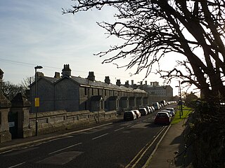
The Grove is a small village located at Tophill on the Isle of Portland in Dorset. The village is found close to the larger village Easton, and is most notable for containing the HM Prison Portland, including its museum Grove Prison Museum. As with the rest of Portland's villages and settlements, The Grove has been designated as a conservation area, as it is a place of special architectural and historic interest. The village was designated in 1981.

St. Peter's Church is a former Church of England church in The Grove, on the Isle of Portland, Dorset. Designed by Major-General Sir Edmund Du Cane, the church was built in 1870-72 and is now a Grade II* Listed building. The gate piers and boundary walls to the north and west of the church are also Grade II Listed, along with the church's vicarage. St. Peter's Church is included on Historic England's "Heritage at Risk" register.

Governor's Community Garden is a public garden, located on the Isle of Portland, Dorset, England. It is found within The Grove village, opposite the site of HM Prison Portland.

Freshwater Bay is a bay on the east side of the Isle of Portland, Dorset, England, south from Church Ope Cove and between the villages of Wakeham and Southwell. It forms part of the Jurassic Coast.

The Salt Pans are two salt pans on the Isle of Portland, Dorset, England. Both pans sit next to one another, and are situated on the coastline of East Weares, the east side of Portland. The pans sit directly below the Young Offenders Institution HM Prison Portland, and are found close to various old historic relics such as the East Weare Rifle Range, Folly Pier, King's Pier and the remains of the Folly Pier Waterworks. The East Weares area, including the Salt Pans, has been labelled a Site of Special Scientific Interest (SSSI), largely due to the scrub and wildlife being of high nature conservation value.

Church of Our Lady and St Andrew is a former Roman Catholic church in The Grove, on the Isle of Portland, Dorset. The church is now in private ownership.

King's Pier is a 17th-century stone shipping quay, located on the Isle of Portland, Dorset, England; part of the Jurassic Coast. It is found at the boundary point of the land owned by Portland Port Ltd, on the east side of the island within the area of East Weares. To the north of the pier is Balaclava Bay, whilst further south along the coastline are the remains of Folly Pier and Folly Pier Waterworks, East Weare Rifle Range, the two Salt Pans, Little Beach and Durdle Pier respectively. When active, King's Pier was one of the most important stone shipping pier sites.

Folly Pier is a disused stone shipping quay, located on the Isle of Portland, Dorset, England; part of the Jurassic Coast. It is found on the east side of the island within the area of East Weares. Other piers within the area include King's Pier and Durdle Pier respectively. Folly Pier dates from the 17th century.

Grove Lime Kiln is a disused 19th century lime kiln on the Isle of Portland, Dorset, England. It is located close to HM Prison Portland and The Grove village. Owned by the prison service, the lime kiln has been Grade II Listed since 2009.

Little Beach is a small secluded beach on the eastern side of the Isle of Portland, Dorset, England; part of the Jurassic Coast. It is found at East Weares, below Grove Point, and is found in close proximity of the two Salt Pans. The East Weares area, including Little Beach, has been labelled a Site of Special Scientific Interest (SSSI), largely due to the surrounding scrub and wildlife being of high nature conservation value.

Inner Pierhead Fort is a 19th-century fort built to defend Portland Harbour at the Isle of Portland, Dorset, England. It is positioned on the end of the inner breakwater, which abuts from the former dockyard of HMNB Portland. The fort was constructed between 1859-1862, and is 100 ft in diameter. The inner breakwater, including the fort, became Grade II Listed in 1978.

HMS Osprey was an anti-submarine training establishment located at the Isle of Portland, Dorset, England. It was active between 1924 and 1941, and again from 1946 to 1999. The helicopter station RNAS Portland formed part of the establishment from 1959 to 1999.


