
Egmont Bight is a shallow embayment at the southern end of the Encombe valley in Dorset, England. It is part of the Jurassic Coast.
Egmont Bight is a shallow embayment at the southern end of the Encombe valley in Dorset, England. It is part of the Jurassic Coast.
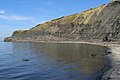
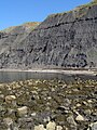
The bay exposes good sections of Upper Kimmeridge shale and mudstone, with some bituminous shale and some small calcareous nodules. [1]

On foot the stony beach is only accessible at low tide by walking 1.0-kilometre (0.6 mi) west around Egmont Point from the beach at Chapman's Pool. There is no safe route down from the clifftop coast path, across Houns-tout cliff, nor around the Freshwater Steps promontory at the beach's western end.

The South West Coast Path is England's longest waymarked long-distance footpath and a National Trail. It stretches for 630 miles (1,014 km), running from Minehead in Somerset, along the coasts of Devon and Cornwall, to Poole Harbour in Dorset. Because it rises and falls with every river mouth, it is also one of the more challenging trails. The total height climbed has been calculated to be 114,931 ft (35,031 m), almost four times the height of Mount Everest. It has been voted 'Britain's Best Walking route' twice in a row by readers of the Ramblers Walk magazine, and regularly features in lists of the world's best walks.

Kimmeridge is a small village and civil parish on the Isle of Purbeck, a peninsula on the English Channel coast in Dorset, England. It is situated about 4.5 miles (7.2 km) south of Wareham and 7 miles (11 km) west of Swanage. In 2013 the estimated population of the civil parish was 90.

The Isle of Purbeck is a peninsula in Dorset, England. It is bordered by water on three sides: the English Channel to the south and east, where steep cliffs fall to the sea; and by the marshy lands of the River Frome and Poole Harbour to the north. Its western boundary is less well defined, with some medieval sources placing it at Flower's Barrow above Worbarrow Bay. According to writer and broadcaster Ralph Wightman, Purbeck "is only an island if you accept the barren heaths between Arish Mell and Wareham as cutting off this corner of Dorset as effectively as the sea." The most southerly point is St Alban's Head.

Purbeck was a local government district in Dorset, England. The district was named after the Isle of Purbeck, a peninsula that forms a large proportion of the district's area. However, it extended significantly further north and west than the traditional boundary of the Isle of Purbeck which is the River Frome. The district council was based in the town of Wareham, which is itself north of the Frome.

Dorset is a county in South West England on the English Channel coast. Covering an area of 2,653 square kilometres (1,024 sq mi); it borders Devon to the west, Somerset to the north-west, Wiltshire to the north-east, and Hampshire to the east. The great variation in its landscape owes much to the underlying geology which includes an almost unbroken sequence of rocks from 200 Ma to 40 Ma and superficial deposits from 2 Ma to the present. In general the oldest rocks appear in the far west of the county, with the most recent (Eocene) in the far east. Jurassic rocks also underlie the Blackmore Vale and comprise much of the coastal cliff in the west and south of the county; and although younger Cretaceous rocks crown some of the highpoints in the west, they are mainly to be found in the centre and east of the county.
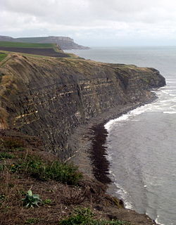
Hen Cliff is part of the Jurassic Coast near Kimmeridge in the Isle of Purbeck, Dorset, England.

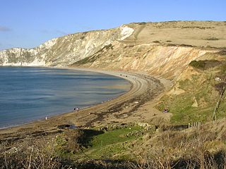
Worbarrow Bay is a large broad and shallow bay just to the east of Lulworth Cove on the Isle of Purbeck, Dorset, England.

Chapman's Pool is a small cove to the west of Worth Matravers on the Isle of Purbeck, in Dorset, England.

Pondfield Cove is a small, secluded, south-facing cove immediately to the east of Worbarrow Tout and west of Gad Cliff on the south coast of the Isle of Purbeck, in Dorset, England. It is about 12 kilometres (7.5 mi) south of Wareham and about 16 kilometres (10 mi) west of Swanage.

Kimmeridge Bay is a bay on the Isle of Purbeck, a peninsula on the English Channel coast in Dorset, England, close to and southeast of the village of Kimmeridge, on the Smedmore Estate. The area is renowned for its fossils, with The Etches Collection in the village of Kimmeridge displaying fossils found by Steve Etches in the area over a 30-year period. It is a popular place to access the coast for tourists. To the east are the Kimmeridge Ledges, where fossils can be found in the flat clay beds.
Worbarrow Tout is a promontory at the eastern end of Worbarrow Bay on Isle of Purbeck in Dorset on the south coast of England, about 6 kilometres (3.7 mi) south of Wareham and about 16 kilometres (10 mi) west of Swanage. Immediately to its east is Pondfield Cove.
Flower’s Barrow is an Iron Age hillfort, built over 2500 years ago, above Worbarrow Bay in Dorset on the south coast of England.

Gad Cliff is a south-facing cliff face, immediately to the east of Worbarrow Tout and Pondfield Cove, on the south coast of the Isle of Purbeck in Dorset, England. Behind it is Gold Down, part of the Lulworth Ranges.

Brandy Bay is a small secluded southwest-facing bay, with an oil shale and shingle beach immediately below Gad Cliff and Tyneham Cap, to the east of Worbarrow Bay and to the west of Hobarrow Bay on the south coast of the Isle of Purbeck, in Dorset, England.

Hobarrow Bay is a small secluded southwest-facing bay, with an oil shale and shingle beach to the southeast of Brandy Bay and to the southwest of Kimmeridge on the south coast of the Isle of Purbeck, in Dorset, England.

The Kimmeridge Oil Field is to the northwest of Kimmeridge Bay, on the south coast of the Isle of Purbeck, in Dorset, England.

Smedmore House is a country house near Kimmeridge, Dorset, in England. It was originally built by Sir William Clavell around 1620, partially rebuilt by Edward Clavell around 1700, and greatly augmented by George Clavell around 1760. English Heritage have designated it a Grade II* listed building. It is not normally open to the public, although there are regular open days and the House can be rented or hired for functions.

Dorset is a county located in the middle of the south coast of England. It lies between the latitudes 50.512°N and 51.081°N and the longitudes 1.682°W and 2.958°W, and occupies an area of 2,653 km². It spans 90 kilometres (56 mi) from east to west and 63 kilometres (39 mi) from north to south.
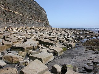
Kimmeridge Ledges is a set of Kimmeridge clay ledges stretching out in to the sea on the Isle of Purbeck, a peninsula on the English Channel coast in Dorset, England.They are located to the southeast of Kimmeridge Bay and south of the villages of Kimmeridge, on the Smedmore Estate.


Coordinates: 50°35′42″N2°4′38″W / 50.59500°N 2.07722°W
| | This Dorset location article is a stub. You can help Wikipedia by expanding it. |