
Swanage is a coastal town and civil parish in the south east of Dorset, England. It is at the eastern end of the Isle of Purbeck and one of its two towns, approximately 6+1⁄4 miles (10 km) south of Poole and 25 miles (40 km) east of Dorchester. In the 2011 census the civil parish had a population of 9,601. Nearby are Ballard Down and Old Harry Rocks, with Studland Bay and Poole Harbour to the north. Within the parish are Durlston Bay and Durlston Country Park to the south of the town. The parish also includes the areas of Herston, just to the west of the town, and Durlston, just to the south.

A discordant coastline occurs where bands of different rock types run perpendicular to the coast.

The Isle of Purbeck is a peninsula in Dorset, England. It is bordered by water on three sides: the English Channel to the south and east, where steep cliffs fall to the sea; and by the marshy lands of the River Frome and Poole Harbour to the north. Its western boundary is less well defined, with some medieval sources placing it at Flower's Barrow above Worbarrow Bay. John Hutchins, author of The History and Antiquities of the County of Dorset, defined Purbeck's western boundary as the Luckford Lake steam, which runs south from the Frome. According to writer and broadcaster Ralph Wightman, Purbeck "is only an island if you accept the barren heaths between Arish Mell and Wareham as cutting off this corner of Dorset as effectively as the sea." The most southerly point is St Alban's Head.

Durdle Door is a natural limestone arch on the Jurassic Coast near Lulworth in Dorset, England. It is privately owned by the Weld Family who own the Lulworth Estate, but it is also open to the public.

Purbeck was a local government district in Dorset, England. The district was named after the Isle of Purbeck, a peninsula that forms a large proportion of the district's area. However, it extended significantly further north and west than the traditional boundary of the Isle of Purbeck which is the River Frome. The district council was based in the town of Wareham, which is itself north of the Frome.

Durlston Country Park is a 320-acre country park and nature reserve stretching along the coast of the Isle of Purbeck on the outskirts of Swanage in Dorset, England. The park is a popular destination for tourists to enjoy the walks, views, visitor centre, climbing, and wildlife, including Durlston Castle, the Great Globe, Tilly Whim Caves, and Anvil Point Lighthouse. It is a gateway to the Jurassic Coast World Heritage Site, forms part of the 630 mile South West Coast Path, and is owned by Dorset Council.

Dorset is a county in South West England on the English Channel coast. Covering an area of 2,653 square kilometres (1,024 sq mi); it borders Devon to the west, Somerset to the north-west, Wiltshire to the north-east, and Hampshire to the east. The great variation in its landscape owes much to the underlying geology, which includes an almost unbroken sequence of rocks from 200 to 40 million years ago (Mya) and superficial deposits from 2 Mya to the present. In general, the oldest rocks appear in the far west of the county, with the most recent (Eocene) in the far east. Jurassic rocks also underlie the Blackmore Vale and comprise much of the coastal cliff in the west and south of the county; although younger Cretaceous rocks crown some of the highpoints in the west, they are mainly to be found in the centre and east of the county.
Purbeck Marble is a fossiliferous limestone found in the Isle of Purbeck, a peninsula in south-east Dorset, England. It is a variety of Purbeck stone that has been quarried since at least Roman times as a decorative building stone.

The Purbeck Group is an Upper Jurassic to Lower Cretaceous lithostratigraphic group in south-east England. The name is derived from the district known as the Isle of Purbeck in Dorset where the strata are exposed in the cliffs west of Swanage.
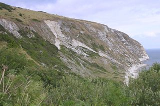
Ballard Cliff is part of the Jurassic Coast near Swanage in the Isle of Purbeck in Dorset, England. The steeply dipping Cretaceous chalk that marks the northern end of Swanage Bay takes over from the Wealden beds at this location. A series of landslides during the late 1990s and early 2000s created a prominent white 'zig-zag' in the scarp. A rotational slip in the Chalk, Upper Greensand and Gault has developed, exposing a section of the soft, blue-grey Gault clay at the base of the cliff.

Worbarrow Bay is a large broad and shallow bay just to the east of Lulworth Cove on the Isle of Purbeck, Dorset, England.
Durlston Bay is a small bay next to a country park of the same name, just south of the resort of Swanage, on the Isle of Purbeck in Dorset, England. It has been a renowned site for Lower Cretaceous fossils since the initial discovery of fragments there by Samuel Beckles in the 1850s.

Worbarrow Tout is a promontory at the eastern end of Worbarrow Bay on Isle of Purbeck in Dorset on the south coast of England, about 6 kilometres (3.7 mi) south of Wareham and about 16 kilometres (10 mi) west of Swanage. Immediately to its east is Pondfield Cove.

Cow Corner is the north-western end of Worbarrow Bay, a small secluded bay on the south coast of the Isle of Purbeck in Dorset, England.

Anvil Point is part of the Jurassic Coast on the Isle of Purbeck in Dorset, England. It is within the grounds of Durlston Country Park and is about 3 kilometres (1.9 mi) from Swanage town centre. Anvil Point Lighthouse is located on the point.

Parson's Barn is a large sea-level cavern below the Ballard Point cliffs, between Studland and Swanage bays in the English Channel. Ballard Point is the headland of the Ballard Downs, an area of chalk downland, on the Isle of Purbeck in Dorset, southern England.

Gad Cliff is a south-facing cliff face, immediately to the east of Worbarrow Tout and Pondfield Cove, on the south coast of the Isle of Purbeck in Dorset, England. Behind it is Gold Down, part of the Lulworth Ranges.

Brandy Bay is a small secluded southwest-facing bay, with an oil shale and shingle beach immediately below Gad Cliff and Tyneham Cap, to the east of Worbarrow Bay and to the west of Hobarrow Bay on the south coast of the Isle of Purbeck, in Dorset, England.

Dorset is a county located in the middle of the south coast of England. It lies between the latitudes 50.512°N and 51.081°N and the longitudes 1.682°W and 2.958°W, and occupies an area of 2,653 km2. It spans 90 kilometres (56 mi) from east to west and 63 kilometres (39 mi) from north to south.

The Purbeck Mining Museum exists to preserve and interpret the historic extractive industries in ball clay mining in the Isle of Purbeck. The museum is located adjacent to Norden station on the Swanage Railway and is open from the end of March to the end of September on weekends, some weekdays and Bank Holidays.
