
Lyme Regis is a town in west Dorset, England, 25 miles (40 km) west of Dorchester and east of Exeter. Sometimes dubbed the "Pearl of Dorset", it lies by the English Channel at the Dorset–Devon border. It has noted fossils in cliffs and beaches on the Heritage or Jurassic Coast, a World Heritage Site. The harbour wall, known as The Cobb, appears in Jane Austen's novel Persuasion, the John Fowles novel The French Lieutenant's Woman and the 1981 film of that name, partly shot in the town. A former mayor and MP was Admiral Sir George Somers, who founded the English colonial settlement of Somers Isles, now Bermuda, where Lyme Regis is twinned with St George's. In July 2015, Lyme Regis joined Jamestown, Virginia in a Historic Atlantic Triangle with St George's. The 2011 Census gave the urban area a population of 4,712, estimated at 4,805 in 2019.

The Jurassic Coast is a World Heritage Site on the English Channel coast of southern England. It stretches from Exmouth in East Devon to Studland Bay in Dorset, a distance of about 96 miles (154 km), and was inscribed on the World Heritage List in mid-December 2001.

Kimmeridge is a small village and civil parish on the Isle of Purbeck, a peninsula on the English Channel coast in Dorset, England. It is situated about 4.5 miles (7.2 km) south of Wareham and 7 miles (11 km) west of Swanage. In 2013 the estimated population of the civil parish was 90.

Dorset is a county in South West England on the English Channel coast. Covering an area of 2,653 square kilometres (1,024 sq mi); it borders Devon to the west, Somerset to the north-west, Wiltshire to the north-east, and Hampshire to the east. The great variation in its landscape owes much to the underlying geology, which includes an almost unbroken sequence of rocks from 200 to 40 million years ago (Mya) and superficial deposits from 2 Mya to the present. In general, the oldest rocks appear in the far west of the county, with the most recent (Eocene) in the far east. Jurassic rocks also underlie the Blackmore Vale and comprise much of the coastal cliff in the west and south of the county; although younger Cretaceous rocks crown some of the highpoints in the west, they are mainly to be found in the centre and east of the county.
The Early Jurassic Epoch is the earliest of three epochs of the Jurassic Period. The Early Jurassic starts immediately after the Triassic-Jurassic extinction event, 201.3 Ma, and ends at the start of the Middle Jurassic 174.1 Ma.
Lyme Bay is an area of the English Channel off the south coast of England. The south western counties of Devon and Dorset front onto the bay.
The Undercliff is the name of several areas of landslip on the south coast of England. They include ones on the Isle of Wight; on the Dorset-Devon border near Lyme Regis; on cliffs near Branscombe in East Devon; and at White Nothe, Dorset. All arose from slump of harder strata over softer clay, giving rise to irregular landscapes of peaks, gullies and slipped blocks, that have become densely vegetated due to their isolation and change of land use. The Kent coast at Folkestone and Sandgate also has similar undercliff areas.

Bran Point is a small headland on the Dorset coast in southern England, about halfway between the small villages of Ringstead to the east and Osmington Mills to the west. There is a picturesque cliff-top path between the two villages via Bran Point.
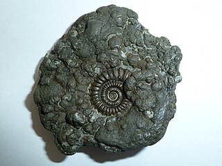
Promicroceras is an extinct ammonite genus from the upper Sinemurian of Europe, named by Leonard Spath in 1925. Promicroceras is included in the family Eoderoceratidae, which is part of the ammonitid superfamily Eoderoceratoidea.

Redcliff Point is on the south coast of England, to the east of Weymouth in Dorset. It lies just past the eastern end of the sweeping Weymouth Bay on the Jurassic Coast, a UNESCO World Heritage landscape known for its geology. Fossils can be found in the Upper Oxford Clay in this area.
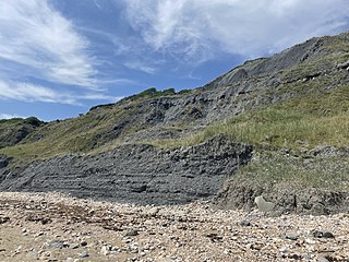
Black Ven is a cliff in Dorset, England between the towns of Charmouth and Lyme Regis. The cliffs reach a height of 130 metres (430 ft). It is part of the Jurassic Coast World Heritage Site. Nearby is an undercliff with an ammonite pavement. The area is popular with tourists due to a number of fossils being found in the area.
Stonebarrow is a coastal hill and sea cliff in the county of Dorset on the south coast of England. It is a well known fossil hunting location, close to the coastal village of Charmouth.
Furzy Cliff, also known as Jordan's Cliff, is located on the coast near the village of Preston, just to the east of Weymouth, Dorset, England. It is at the northeastern end of Weymouth Beach, looking out over Weymouth Bay to Portland Harbour and the Isle of Portland. Close by to the east is Bowleaze Cove. Just inland to the north are Jordan Hill and the remains of the Jordan Hill Roman Temple. On the top of the cliff there is a large grass area with good views.

Ware Cliffs are a set of long cliffs which stretch westwards from the town of Lyme Regis in Dorset to the Ware hamlet in the East Devon district of Devon, England. They are situated near Pinhay Bay and their highest point is the Black Ven, which reaches a height of approximately 137 metres (449 ft).

Clay Ope is on the west side of the Isle of Portland in Dorset, England. It forms part of the Jurassic Coast. The geology of the area includes Purbeck Beds, Portland Stone, Portland Sand, and Kimmeridge Clay. Above Clay Ope is West Cliff.

Monmouth Beach is a pebble and rock beach stretching approximately 1 mile (1.6 km) westwards from the harbour at Lyme Regis, West Dorset to Pinhay Bay, East Devon. It is part of the Jurassic Coast, situated below Ware Cliffs, and includes Poker's Pool, Virtle Rock and Chippel Bay. Virtle Rock is the farthest islet from the coast in Poker's Pool.

Dorset is a county located in the middle of the south coast of England. It lies between the latitudes 50.512°N and 51.081°N and the longitudes 1.682°W and 2.958°W, and occupies an area of 2,653 km2. It spans 90 kilometres (56 mi) from east to west and 63 kilometres (39 mi) from north to south.

The Great Southwell Landslip occurred in 1734 on the Isle of Portland, Dorset, England near the southerly village of Southwell and extended for a length of 1.5 miles (2.4 km) between Durdle Pier and Freshwater Bay. It remains Britain's second largest recorded historical landslide.

The Charmouth Mudstone Formation is a geological formation in England. It preserves fossils dating back to the early part of the Jurassic period (Sinemurian–Pliensbachian). It forms part of the lower Lias Group. It is most prominently exposed at its type locality in cliff section between Lyme Regis and Charmouth but onshore it extends northwards to Market Weighton, Yorkshire, and in the subsurface of the East Midlands Shelf and Wessex Basin. The formation is notable for its fossils, including those of ammonites and marine reptiles and rare dinosaur remains. The formation played a prominent role in the history of early paleontology, with its Lyme Regis-Charmouth exposure being frequented by fossil collectors including Mary Anning.
