
The Kimmeridge Oil Field is an oil drilling site, northwest of Kimmeridge Bay, on the south coast of the Isle of Purbeck, in Dorset, England.
The Kimmeridge Oil Field is an oil drilling site, northwest of Kimmeridge Bay, on the south coast of the Isle of Purbeck, in Dorset, England.
The small village Kimmeridge is about 6 kilometres (3.7 mi) south of Wareham and about 8 kilometres (5.0 mi) west of Swanage. The Kimmeridge oil field is part of the Wytch Farm oil field and processing facility operated by Perenco. Wytch Farm is on the southern shore of Poole Harbour and about 12 kilometres (7.5 mi) northeast of the oil well. Kimmeridge Bay and its cliffs are part of the Jurassic Coast, a World Heritage Site, because of the quality and variety of geological landforms along the coast. [1]
In Dorset the search for oil started back in 1935. Between 1958 and 1980 six wells were drilled in Kimmeridge Bay. The first drilling of the Kimmeridge oil field was the Broadbench 1 well to the north of Broadbench, which revealed neither oil nor gas. The second well Broadbench 2, later renamed Kimmeridge 1, was drilled in 1959 and both oil and gas were discovered. The Kimmeridge 2 well (drilled 1960) to the east of the car park showed only small amounts of oil, but it was retained as an observation well. The drillings Kimmeridge 3 (drilled 1959 to 1960) at Broad Bench and Kimmeridge 5 (drilled in 1980 near the Kimmeridge 1 well) exposed only weak oil contents, while the drilling Kimmeridge 4 in 1960, east of Brandy Bay by Long Ebb, revealed no exposures due to a mechanical breakdown.
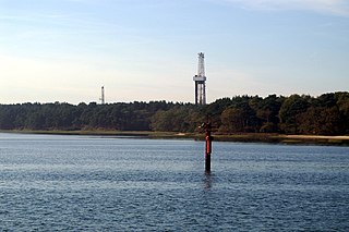
The Kimmeridge 1 well site, is a small site, with a single beam pump or "nodding donkey" which has been pumping continually since 1961, making it the oldest working oil pump in the UK. [2] The well once produced 350 barrels per day, but currently yields around 65 barrels per day (10.3 m3/d) from the Jurassic strata that lie around 350 metres (1,150 ft) below the cliff. [3] The well has been operating this long because it is tapped into a network of connected reserves, however the yield is decreasing. The oil is transported by tanker to Wytch Farm, from where it is piped to the storage tanks at Hamble-le-Rice on Southampton Water before being shipped to the main refinery. [4] The nodding donkey has a high wire-mesh fence around it but it can be viewed clearly from all sides. The well provides views over the Kimmeridge Ledges and 8 kilometres (5.0 mi) of coast where bedrock extends at least half a kilometre out to sea under the waves.

The Jurassic Coast is a World Heritage Site on the English Channel coast of southern England. It stretches from Exmouth in East Devon to Studland Bay in Dorset, a distance of about 96 miles (154 km), and was inscribed on the World Heritage List in mid-December 2001.

Kimmeridge is a small village and civil parish on the Isle of Purbeck, a peninsula on the English Channel coast in Dorset, England. It is situated about 4.5 miles (7.2 km) south of Wareham and 7 miles (11 km) west of Swanage. In 2013 the estimated population of the civil parish was 90.

The Isle of Purbeck is a peninsula in Dorset, England. It is bordered by water on three sides: the English Channel to the south and east, where steep cliffs fall to the sea; and by the marshy lands of the River Frome and Poole Harbour to the north. Its western boundary is less well defined, with some medieval sources placing it at Flower's Barrow above Worbarrow Bay. John Hutchins, author of The History and Antiquities of the County of Dorset, defined Purbeck's western boundary as the Luckford Lake stream, which runs south from the Frome. According to writer and broadcaster Ralph Wightman, Purbeck "is only an island if you accept the barren heaths between Arish Mell and Wareham as cutting off this corner of Dorset as effectively as the sea." The most southerly point is St Alban's Head.

Purbeck was a local government district in Dorset, England. The district was named after the Isle of Purbeck, a peninsula that forms a large proportion of the district's area. However, it extended significantly further north and west than the traditional boundary of the Isle of Purbeck which is the River Frome. The district council was based in the town of Wareham, which is itself north of the Frome.
Wytch Farm is an oil field and processing facility in the Purbeck district of Dorset, England. It is the largest onshore oil field in Western Europe. The facility, taken over by Perenco in 2011, was previously operated by BP. It is located in a coniferous forest on Wytch Heath on the southern shore of Poole Harbour, two miles (3.2 km) north of Corfe Castle. Oil and natural gas (methane) are both exported by pipeline; liquefied petroleum gas is exported by road tanker.

Dorset is a county in South West England on the English Channel coast. Covering an area of 2,653 square kilometres (1,024 sq mi); it borders Devon to the west, Somerset to the north-west, Wiltshire to the north-east, and Hampshire to the east. The great variation in its landscape owes much to the underlying geology, which includes an almost unbroken sequence of rocks from 200 to 40 million years ago (Mya) and superficial deposits from 2 Mya to the present. In general, the oldest rocks appear in the far west of the county, with the most recent (Eocene) in the far east. Jurassic rocks also underlie the Blackmore Vale and comprise much of the coastal cliff in the west and south of the county; although younger Cretaceous rocks crown some of the highpoints in the west, they are mainly to be found in the centre and east of the county.

Chapman's Pool is a small cove to the west of Worth Matravers on the Isle of Purbeck, in Dorset, England.
This is a list of oil and gas fields operated by BP.

Egmont Bight is a shallow embayment at the southern end of the Encombe valley in Dorset, England. It is part of the Jurassic Coast.

The East Midlands Oil Province, also known as the East Midlands Petroleum Province, covers the petroliferous geological area across the north-eastern part of the East Midlands of England that has a few small oil fields.
The Miller oilfield is a deep reservoir under the North Sea, 240 kilometres north-east of Peterhead in UKCS Blocks 16/7b and 16/8b. It was discovered in 1983 by BP in a water depth of 100 metres. Production from Miller field started in June 1992, and plateau production was from late 1992 to 1997 at rates of up to 150,000 barrels (24,000 m3) of oil and 255 million cu ft (7.2 million m3) of gas per day at standard conditions. Miller produced some 345 million barrels (54,900,000 m3) of oil during its lifetime. The field is named after Hugh Miller who contributed to Scottish geology in the early nineteenth century.

Kimmeridge Bay is a bay on the Isle of Purbeck, a peninsula on the English Channel coast in Dorset, England, close to and southeast of the village of Kimmeridge, on the Smedmore Estate. The area is renowned for its fossils, with The Etches Collection in the village of Kimmeridge displaying fossils found by Steve Etches in the area over a 30-year period. It is a popular place to access the coast for tourists. To the east are the Kimmeridge Ledges, where fossils can be found in the flat clay beds.
Perenco is an independent Anglo-French oil and gas company with a headquarters in London and Paris. It conducts exploration and production activities in 16 countries around the globe. Perenco is involved in operations both onshore and offshore with production equal to approximately 450,000-barrel (72,000 m3) of oil equivalent per day.

Brandy Bay is a small secluded southwest-facing bay, with an oil shale and shingle beach immediately below Gad Cliff and Tyneham Cap, to the east of Worbarrow Bay and to the west of Hobarrow Bay on the south coast of the Isle of Purbeck, in Dorset, England.

Hobarrow Bay is a small secluded southwest-facing bay, with an oil shale and shingle beach to the southeast of Brandy Bay and to the southwest of Kimmeridge on the south coast of the Isle of Purbeck, in Dorset, England.

Dorset is a county located in the middle of the south coast of England. It lies between the latitudes 50.512°N and 51.081°N and the longitudes 1.682°W and 2.958°W, and occupies an area of 2,653 km2. It spans 90 kilometres (56 mi) from east to west and 63 kilometres (39 mi) from north to south.

The Bridport Sand Formation is a sandstone geological formation in central and southern England, noted for forming distinctive cliffs on the Jurassic Coast World Heritage Site. Bridport Sand is of Toarcian age and is found in the Worcester and Wessex Basins.
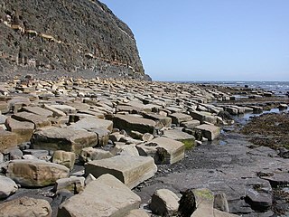
Kimmeridge Ledges is a set of Kimmeridge clay ledges stretching out in to the sea on the Isle of Purbeck, a peninsula on the English Channel coast in Dorset, England.They are located to the southeast of Kimmeridge Bay and south of the villages of Kimmeridge, on the Smedmore Estate.

Burning Cliff is a cliff under the White Nothe headland at the eastern end of Ringstead Bay, in Dorset, England. The area is well known for its geology and fossils.
{{cite book}}: |work= ignored (help)