Swyre Head, Lulworth

Last updated
View east from White Nothe towards Bat's Head with the taller Swyre Head behind. Bats head from white nothe.jpg
View east from White Nothe towards Bat's Head with the taller Swyre Head behind.
The dry valley of Scratchy Bottom, between Swyre Head and Durdle Door. Scratchy bottom dorset.jpg
The dry valley of Scratchy Bottom, between Swyre Head and Durdle Door.

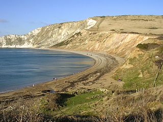
Swyre Head, Lulworth is a hill and sea cliff which lies on the Jurassic Coast between Bat's Head to the west and Durdle Door to the east, close to Lulworth (further to the east) in Dorset, England. It is located approximately 8 miles (12.9 km) east of Weymouth and 14 miles (22.5 km) west of Swanage.

Jurassic Coast World Heritage Site on the coast of southern England

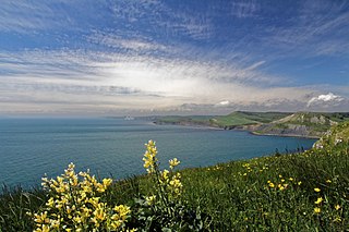
The Jurassic Coast is a World Heritage Site on the English Channel coast of southern England. It stretches from Exmouth in East Devon to Studland Bay in Dorset, a distance of about 96 miles (154 km), and was inscribed on the World Heritage List in mid-December 2001.

Bats Head

Bat's Head is a chalk headland on the Dorset coast in southern England, located between Swyre Head and Durdle Door to the east, and Chaldon Hill and White Nothe to the west. At the base of the headland is the small Bat's Cave.

Durdle Door natural limestone arch

Durdle Door is a natural limestone arch on the Jurassic Coast near Lulworth in Dorset, England.

Swyre Head, Lulworth, lies only about 8.5 miles (13.7 km) west of another Swyre Head, which is located close to the village of Kingston and which is the highest point on the peninsula known as the Isle of Purbeck.

Swyre Head mountain in the United Kingdom

Swyre Head is the highest point of the Purbeck Hills and the Isle of Purbeck in Dorset, on the south coast of England. The hill Swyre Head lies about 2 kilometres (1 mi) southwest of the village Kingston, about 5 kilometres (3 mi) south of Corfe Castle and 8 kilometres (5 mi) west of Swanage.

Isle of Purbeck peninsula in Dorset, England

The Isle of Purbeck is a peninsula in Dorset, England. It is bordered by water on three sides: the English Channel to the south and east, where steep cliffs fall to the sea; and by the marshy lands of the River Frome and Poole Harbour to the north. Its western boundary is less well defined, with some medieval sources placing it at Flower's Barrow above Worbarrow Bay. According to writer and broadcaster Ralph Wightman, Purbeck "is only an island if you accept the barren heaths between Arish Mell and Wareham as cutting off this corner of Dorset as effectively as the sea." The most southerly point is St Alban's Head. Its coastline is suffering from erosion.

The cliffs of Swyre Head, Lulworth, are of chalk and are steep, with grassland and a footpath above. The footpath runs close to the cliff edge and is steeply undulating. Despite the steepness, it is popular for walks [1] [2] and the scenery is spectacular. [3] [4] [5]

Chalk A soft, white, porous sedimentary rock made of calcium carbonate

Chalk is a soft, white, porous, sedimentary carbonate rock, a form of limestone composed of the mineral calcite. Calcite is an ionic salt called calcium carbonate or CaCO3. It forms under reasonably deep marine conditions from the gradual accumulation of minute calcite shells (coccoliths) shed from micro-organisms called coccolithophores. Flint (a type of chert) is very common as bands parallel to the bedding or as nodules embedded in chalk. It is probably derived from sponge spicules or other siliceous organisms as water is expelled upwards during compaction. Flint is often deposited around larger fossils such as Echinoidea which may be silicified (i.e. replaced molecule by molecule by flint).

Between Swyre Head and the natural rock arch of Durdle Door is a small dry valley known as Scratchy Bottom.

Dry valley valley, that does not regularly sustain surface water flow

A dry valley may develop on many kinds of permeable rock, such as limestone and chalk, or sandy terrains that do not regularly sustain surface water flow. Such valleys do not hold surface water because it sinks into the permeable bedrock.

Scratchy Bottom Geographical feature in Dorset UK

Scratchy Bottom is a clifftop valley between Durdle Door and Swyre Head in Dorset, England. A dry valley in the chalk, it is surrounded by farmland at its sides and landward end, with cliffs at the seaward end.

Related Research Articles

South West Coast Path

The South West Coast Path is England's longest waymarked long-distance footpath and a National Trail. It stretches for 630 miles (1,014 km), running from Minehead in Somerset, along the coasts of Devon and Cornwall, to Poole Harbour in Dorset. Because it rises and falls with every river mouth, it is also one of the more challenging trails. The total height climbed has been calculated to be 114,931 ft (35,031 m), almost four times the height of Mount Everest. It has been voted 'Britain's Best Walking route' twice in a row by readers of the Ramblers Walk magazine, and regularly features in lists of the world's best walks.

Lulworth Cove cove

Lulworth Cove is a cove near the village of West Lulworth, on the Jurassic Coast in Dorset, southern England. The cove is one of the world's finest examples of such a landform, and is a World Heritage Site and tourist location with approximately 500,000 visitors every year, of whom about 30 percent visit in July and August. It is close to the rock arch of Durdle Door and other Jurassic Coast sites.

Purbeck District Non-metropolitan district in England

Purbeck is a local government district in Dorset, England. The district is named after the Isle of Purbeck, a peninsula that forms a large proportion of the district's area. However the district extends significantly further north and west than the traditional boundary of the Isle of Purbeck along the River Frome. The district council is based in the town of Wareham, which is itself north of the River Frome.

Ringstead Bay

Ringstead Bay and the small village of Ringstead are located on the coast in Dorset, southern England. The area lies on the Jurassic Coast and is known for its natural environment and fossils.

Stair Hole

Stair Hole is a small cove located just west of Lulworth Cove in Dorset, southern England. The folded limestone strata known as the Lulworth crumple are particularly visible at Stair Hole. There are several caves visible from the seaward side of Stair Hole; Cathedral Cavern is supported by pillars of rock rising out of the water. The rock structure was created during the Alpine orogeny and exposed by subsequent erosion.

White Nothe

White Nothe is a chalk headland on the English Channel coast at the eastern end of Ringstead Bay, east of Weymouth in Dorset, England. The area is well known for its geology and fossils. Its flanks are the result of prehistoric landslides and the inaccessible slopes of the undercliff provide a secluded wildlife habitat.

Bindon Hill Iron Age earthwork in Dorset, England

Bindon Hill is an extensive Iron Age earthwork enclosing a coastal hill area on the Jurassic Coast near Lulworth Cove in Dorset, England, about 19 kilometres (12 mi) west of Swanage, about 6 kilometres (3.7 mi) south west of Wareham, and about 17 kilometres (11 mi) south east of Dorchester. It is within an Area of Outstanding Natural Beauty.

St Oswalds Bay

St Oswald's Bay is located near Lulworth on the Jurassic Coast in Dorset, England.

Dungy Head

Dungy Head is a coastal promontory located west of Lulworth Cove on the Jurassic Coast in Dorset, England. It forms the eastern end of St Oswald's Bay. It is composed of Portland stone strata. The surrounding area is popular for coastal walks, which yield impressive views. Cliff-climbing however is dangerous and not recommended.

Flowers Barrow Iron Age hill fort in Dorset, England

Flower’s Barrow is an Iron Age hillfort, built over 2500 years ago, above Worbarrow Bay in Dorset on the south coast of England.

Brandy Bay, Dorset

Brandy Bay is a small secluded southwest-facing bay, with an oil shale and shingle beach immediately below Gad Cliff and Tyneham Cap, to the east of Worbarrow Bay and to the west of Hobarrow Bay on the south coast of the Isle of Purbeck, in Dorset, England.

Ridgeway Hill mountain in United Kingdom

Ridgeway Hill, also referred to as Grange Hill or Steeple Hill, is the third highest point of the Purbeck Hills in the county of Dorset standing at 199 metres (653 ft), is one of the only hills with a prominence of over a hundred metres, HuMPs, in the county. Near the top of the hill is an 18th-century folly known as Grange Arch, built by the former owner of Creech Grange, Denis Bond. On the eastern spur of the hill is Stonehill Down which is now a nature reserve. There are also good views of Swyre Head on the Jurassic Coast.

Chaldon Hill

Chaldon Hill, also called Chaldon Down, is one of the highest hills, 178 metres (584 ft), on South Dorset's Jurassic Coast in England. The summit is about 1.5 miles (2.4 km) west of Durdle Door.

Arish Mell

Arish Mell is a small embayment and beach between Mupe and Worbarrow Bays in Dorset, England. It is part of the Jurassic Coast.

Tyneham Cap

Tyneham Cap is a prominent, grassy knoll, 167 metres (548 ft) high, on the South West Coast Path in Dorset, England. It rises above Brandy Bay and has extensive views along the Jurassic Coast across Kimmeridge Bay towards Swyre Head and St Aldhelm's Head to the east, and across Worbarrow Bay to Bindon Hill above Lulworth Cove to the west. It is classified as a TuMP thanks to its local prominence.

References

Coordinates: 50°37′26″N2°17′06″W / 50.6238°N 2.2851°W / 50.6238; -2.2851

Geographic coordinate system Coordinate system

A geographic coordinate system is a coordinate system that enables every location on Earth to be specified by a set of numbers, letters or symbols. The coordinates are often chosen such that one of the numbers represents a vertical position and two or three of the numbers represent a horizontal position; alternatively, a geographic position may be expressed in a combined three-dimensional Cartesian vector. A common choice of coordinates is latitude, longitude and elevation. To specify a location on a plane requires a map projection.