Charmouth

Last updated

Charmouth
View of Charmouth from South West Coast Path.png
View of Charmouth.
Dorset UK location map.svg
Red pog.svg
Charmouth
Location within Dorset
Population1,310 (2013 est.) [1]
OS grid reference SY364934
Civil parish
  • Charmouth
Unitary authority
Ceremonial county
Region
Country England
Sovereign state United Kingdom
Post town BRIDPORT
Postcode district DT6
Dialling code 01297
Police Dorset
Fire Dorset and Wiltshire
Ambulance South Western
UK Parliament
Website Charmouth Portal
List of places
UK
England
Dorset
50°44′12″N2°54′09″W / 50.7368°N 2.9026°W / 50.7368; -2.9026
Golden Cap viewed from Charmouth beach Golden Cap from Charmouth - geograph.org.uk - 1184579.jpg
Golden Cap viewed from Charmouth beach

Charmouth is a village and civil parish in west Dorset, England. The village is situated on the mouth of the River Char, around 1+12 miles (2 km) north-east of Lyme Regis. Dorset County Council estimated that in 2013 the population of the civil parish was 1,310. [1] In the 2011 Census the population of the parish, combined with the small parish of Catherston Leweston to the north, was 1,352. [2]

Contents

History

The history of Charmouth dates back to the Iron Age when a Celtic tribe, the Durotriges, founded a settlement. Evidence of hill forts can still be seen in the area. The name Charmouth originated from the Saxon 'Cerne' meaning stony river, Charmouth was therefore known as 'Cernmunde'. [3]

Historian George Roberts wrote: [4]

During the Saxon period, the neighbouring coast was particularly subject to the invasions of the Danes, concerning whom so much has been written. In 787, the Danes, Northern men, or Normans [a] , landed at Portland from three ships, to reconnoitre the country, which they did without interruption, as the Saxons had neglected their marine. A. D. 833, according to the Saxon Chronicle , though some of our historians place the event in 831 or 832, a dreadful battle was fought at Charmouth. The Danes having met with repulses in other parts of the kingdom sailed to Charmouth where having landed, Speed says, "they made cruel ravage and slaughter." Their fleet consisted of 35 ships, containing a powerful army: their whole force, Huntingdon remarks, must have amounted to 17,500 men; other writers have estimated their numbers at about 15,000. Egbert collected the whole force of the county, and marched to attack them, after they had continued their ravages, according to Matthew of Westminster, about a twelve month. The king had nearly succeeded in cutting them off as they were forming; he threw them into great confusion, but continual supplies of men from the ships turned the scale in their favour. The Saxons were routed: the night alone prevented their destruction by the infuriated invaders, by the favour of which, Speed says, the king hardly escaped. Among the number of the slain were two earls, his principal officers, Dudda and Osmond, Wigen, bishop of Sherborne, and Hereferth, bishop of Winton. The Danes, finding a settlement would be liable to the attacks of the brave Egbert, retired to their ships with precipitation, and set sail. They continued to hover about the coast. In 840, they effected a landing on the same spot, (set Carrum,) from the same number of ships. Ethelwulf's army, which he headed in person, advanced to encounter them: a bloody battle ensued, which, after a desperate struggle, terminated in the Danes remaining masters of the field, though they shortly afterwards retired without any spoil. A successive series of invasions followed.

In 1086 in the Domesday Book Charmouth was recorded as Cernemude; [5] it had 22 households, 3 ploughlands and 16 acres (6.5 ha) of meadow. It was in Whitchurch Canonicorum Hundred and the tenant-in-chief was Count Robert of Mortain. [6]

The buildings on either side of Charmouth's main street vary in age; some of the smaller cottages date from the 17th or 18th century, while others are built in later Regency style. A number of buildings in the village have listed building status. [7]

In the 18th and 19th centuries Charmouth village was a noted resort, with visitors including novelist Jane Austen who wrote that it was "a nice place for sitting in unwearied contemplation". [8]

Church

The present parish church, dedicated to Saint Andrew, [9] was built in 1836, replacing an earlier building of circa 1503, which itself had replaced a mediaeval structure. [10] Treves described it as "exceptionally ugly". [11] [12]

Abbots House

The Abbots House, formerly The Queens Armes Hotel The Abbots House Restaurant - geograph.org.uk - 963547.jpg
The Abbots House, formerly The Queens Armes Hotel

Abbots House (previously The Queens Armes Hotel) is a grade II listed, early 16th-century house that was re-faced in the 18th century. [13] It once belonged to Forde Abbey and the badge of Catherine of Aragon was found worked into the plaster of an upstairs room. [14]

The inn gave shelter to the fugitive King Charles II on 22 September 1651, when he came disguised looking for a boat to take him to France following his defeat at the Battle of Worcester. A small trading ship was found bound for St Malo. The master, Stephen Limbry, agreed to pick up the King from Charmouth beach and transport him to the ship, but just two hours before the pick up Limbry told his wife, who locked him in his room and stole his clothes to ensure he would not become involved. [15] On the following day Charles left Charmouth pursued by troops, who were alerted to his presence by an employee of the inn. [16]

Governance

Charmouth was in its own electoral ward, which also includes Wootton Fitzpaine and the surrounding area. It had a population of 1,697 in the 2011 census. [17]

Charmouth is part of the West Dorset constituency for elections to the House of Commons of the United Kingdom.

After 2019 structural changes to local government in England, Charmouth is part of the Lyme and Charmouth ward which elects 1 member to Dorset Council. [18]

Geography

Ichthyosaur fossil from Charmouth Ichthyosaur sp. 22.jpg
Ichthyosaur fossil from Charmouth

Charmouth is a coastal village which overlooks Lyme Bay and is part of the Jurassic Coast. It lies among steep hills and is sited on a sloping site to the west of the River Char, close to its mouth at the English Channel. Stonebarrow Hill is to the east, Black Venn to the west, and Golden Cap, the highest cliff on the south coast of England at 191 metres (627 ft), is 2+12 miles (4 km) to the east. The National Trust owns significant portions of the surrounding area.

The cliffs above the beach are a noted source of fossils from the Jurassic period. [19]

Amenities

Charmouth Heritage Coast Centre Charmouth Heritage Coast Centre - geograph.org.uk - 709316.jpg
Charmouth Heritage Coast Centre

There are shops and cafes by the beach and on the main street to serve locals and tourists, including a fossil shop, cafés, bakers, two pubs, and ironmonger. The Charmouth Heritage Coast Centre is based in a long-disused cement factory on the foreshore. Charmouth Primary School is located to the south of the village within view of the beach. The Barrs Lane Recreation Ground has children's play equipment and grass pitches, and is the site of an annual summer 'party in the park' offering family entertainment.

Noted person

See also

Related Research Articles

<span class="mw-page-title-main">Dorset</span> County of England

Dorset is a ceremonial county in South West England. It is bordered by Somerset to the north-west, Wiltshire to the north and the north-east, Hampshire to the east, the Isle of Wight across the Solent to the south-east, the English Channel to the south, and Devon to the west. The largest settlement is Bournemouth, and the county town is Dorchester.

<span class="mw-page-title-main">Lyme Regis</span> Coastal town in Dorset, England

Lyme Regis is a town in west Dorset, England, 25 miles (40 km) west of Dorchester and east of Exeter. Sometimes dubbed the "Pearl of Dorset", it lies by the English Channel at the Dorset–Devon border. It has noted fossils in cliffs and beaches on the Jurassic Coast, a World Heritage Site and heritage coast. The harbour wall, known as The Cobb, appears in Jane Austen's novel Persuasion, the John Fowles novel The French Lieutenant's Woman and the 1981 film of that name, partly shot in the town.

<span class="mw-page-title-main">Jurassic Coast</span> World Heritage Site on the coast of southern England

The Jurassic Coast is a World Heritage Site on the English Channel coast of southern England. It stretches from Exmouth in East Devon to Studland Bay in Dorset, a distance of about 96 miles (154 km), and was inscribed on the World Heritage List in mid-December 2001.

<span class="mw-page-title-main">Abbotsbury</span> Village in Dorset, England

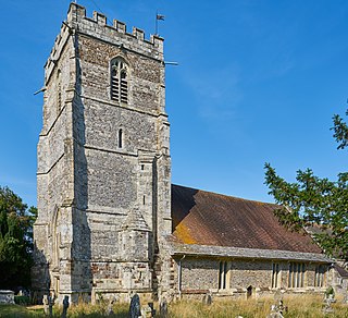
Abbotsbury is a village and civil parish in the English county of Dorset. The settlement is in the unitary authority of Dorset about 1 mile (1.6 km) inland from the English Channel coast. The village, including Chesil Beach, the swannery and subtropical gardens, is owned by the Ilchester Estate, which owns 61 square kilometres of land in Dorset. In the 2011 census the civil parish had a population of 481.

<span class="mw-page-title-main">Studland</span> Human settlement in England

Studland is a village and civil parish on the Isle of Purbeck in Dorset, England. The village is located about 2 miles (3.2 km) north of the town of Swanage, over a steep chalk ridge, and 3 miles (4.8 km) south of the South East Dorset conurbation at Sandbanks, from which it is separated by Poole Harbour. The parish includes Brownsea Island within the harbour. In the 2011 census the parish had 182 households and a population of 425, though many of the houses in the village are holiday homes, second homes, or guest houses, and the village's population varies depending upon the season.

<span class="mw-page-title-main">Seaton, Devon</span> Town in Devon, England

Seaton is a seaside town, fishing harbour and civil parish in East Devon on the south coast of England, between Axmouth and Beer. It faces onto Lyme Bay and is on the Dorset and East Devon Coast Jurassic Coast World Heritage Site. A sea wall provides access to the mostly shingle beach stretching for about a mile, and a small harbour, located mainly in the Axmouth area.

<span class="mw-page-title-main">West Dorset</span> Former non-metropolitan district in England

West Dorset was a local government district in Dorset, England. The district was formed on 1 April 1974 under the Local Government Act 1972, and was a merger of the boroughs of Bridport, Dorchester and Lyme Regis, along with Sherborne urban district and the rural districts of Beaminster, Bridport, Dorchester and Sherborne. Its council was based in Dorchester.

<span class="mw-page-title-main">Cranborne</span> Human settlement in England

Cranborne is a village in East Dorset, England. At the 2011 census, the parish had a population of 779, remaining unchanged from 2001.

<span class="mw-page-title-main">Burton Bradstock</span> Human settlement in England

Burton Bradstock is a village and civil parish in Dorset, England, approximately 2+12 miles (4 km) southeast of Bridport and 12 mile (0.8 km) inland from the English Channel at Chesil Beach. In the 2011 Census the parish had a population of 948. The village lies in the Bride Valley, close to the mouth of the small River Bride. It comprises 16th- and 17th-century thatched cottages, a parish church, two pubs, a primary school, shop, post office stores, beach café, hotel, garage, village hall, reading room a library. The parish has a National Coastwatch Institution Station, Lyme Bay Station.

<span class="mw-page-title-main">Chideock</span> Human settlement in England

Chideock is a village and civil parish in south west Dorset, England, situated close to the English Channel between Bridport and Lyme Regis. Dorset County Council's 2013 estimate of the parish population is 550.

<span class="mw-page-title-main">Bere Regis</span> Human settlement in England

Bere Regis is a village and civil parish in Dorset, England, situated 6 miles (9.7 km) north-west of Wareham. In the 2011 census the civil parish had a population of 1,745.

<span class="mw-page-title-main">Whitchurch Canonicorum</span> Human settlement in England

Whitchurch Canonicorum is a village and civil parish in southwest Dorset, England, situated in the Marshwood Vale 5 miles (8.0 km) west-northwest of Bridport. In the 2011 Census the parish – which includes the settlements of Morcombelake, Ryall and Fishpond Bottom – had a population of 684.

<span class="mw-page-title-main">Wyke Regis</span> Human settlement in England

Wyke Regis is a village in south Dorset, England. The village is part of the south western suburbs of Weymouth, on the northern shore of Portland Harbour and the south-eastern end of Chesil Beach. Wyke is 15 kilometres (9 mi) south of the county town, Dorchester. The village has a population of around 5,500.

<span class="mw-page-title-main">Lyme Bay</span> Area of the English Channel

Lyme Bay is an area of the English Channel off the south coast of England. The south western counties of Devon and Dorset front onto the bay.

<span class="mw-page-title-main">Carhampton</span> Village and civil parish in Somerset, England

Carhampton is a village and civil parish in Somerset, England, 4 miles (6.4 km) to the east of Minehead.

<span class="mw-page-title-main">Uplyme</span> Village in Devon, England

Uplyme is an English village and civil parish in East Devon on the Devon-Dorset border and the River Lym, adjacent to the Dorset coastal town of Lyme Regis. It has a population of approximately 1700 recounted as 1663 at the 2011 census. Uplyme is situated in the electoral ward of Trinity whose population at the above census was 2,521.

<span class="mw-page-title-main">Rousdon</span> Village in Devon, England

Rousdon is a village and former civil parish, now in the parish of Combpyne Rousdon, in the East Devon district, in the county of Devon, England. It is off the A3052 road between Colyford and Lyme Regis in Dorset. In 1931 the parish had a population of 41. On 1 April 1939 the parish was abolished to form "Combpyne Rousdon".

<span class="mw-page-title-main">Black Ven</span>

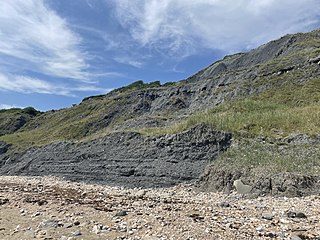
Black Ven is a cliff in Dorset, England between the towns of Charmouth and Lyme Regis. The cliffs reach a height of 130 metres (430 ft). It is part of the Jurassic Coast World Heritage Site. Nearby is an undercliff with an ammonite pavement. The area is popular with tourists due to a number of fossils being found in the area.

<span class="mw-page-title-main">Dinosaurland Fossil Museum</span> Fossil museum in Dorset, England

Dinosaurland Fossil Museum is a privately owned fossil museum in Lyme Regis, on the Jurassic Coast in Dorset, England. The museum is located in a historic Grade I listed former congregational church building.

<span class="mw-page-title-main">River Lym</span> River in Dorset, England

The River Lym or River Lim is a short river, some 5 km in length, that flows through the Devon-Dorset border. It rises from multiple springs at Raymond's Hill, near the village of Uplyme in East Devon, and flows southeasterly through Dorset, into the English Channel via Lyme Bay in the town of Lyme Regis, Dorset. The river falls over 200 metres from its source.

References

  1. 1 2 "Parish Population Data". Dorset County Council. 20 January 2015. Archived from the original on 15 January 2016. Retrieved 27 February 2015.
  2. "Area: Charmouth (Parish). Key Figures for 2011 Census: Key Statistics". Neighbourhood Statistics. Office for National Statistics . Retrieved 18 January 2014.
  3. The History and Antiquities of the Borough of Lyme Regis and Charmouth George Roberts, 1834
  4. Roberts, p. 11
  5. "Dorset A-G". The Domesday Book Online. domesdaybook.co.uk. Retrieved 27 February 2015.
  6. "Place: Charmouth". Open Domesday. domesdaymap.co.uk. Archived from the original on 27 February 2015. Retrieved 27 February 2015.
  7. "Map of listed buildings in Charmouth". West Dorset District Council. Archived from the original on 2 September 2011.
  8. Visit Lyme Regis; Jane Austen: Persuasion and Lyme Regis; accessed 2022-11-11
  9. formerly to Saint Nicholas; the dedication was apparently changed in the 1860s
  10. Historic England
  11. cited in "Dorset Life", Near Golden Cap, February 2012
  12. DorsetChurches.org.uk: Charmouth (with photo)
  13. Historic England. "Details from listed building database (1324126)". National Heritage List for England . Retrieved 27 April 2015.
  14. Whaley, Peta (2002). West Country History: Dorset. Intellect Books. p. 49. ISBN   978-1-84150-803-0.
  15. Roberts, p. 115
  16. Newman, P. R. (1985). Atlas of the English Civil War. Taylor & Francis. p. 109. ISBN   978-0-7099-1811-0.
  17. "Ward population 2011" . Retrieved 26 February 2015.
  18. "Area profile for Lyme & Charmouth - Dorset Council". gi.dorsetcouncil.gov.uk. Retrieved 24 February 2024.
  19. "Dorset and East Devon Coast". UNESCO World Heritage Centre. 2001.

Notes

a. ^ Normans during this period refers to the original Germanic nation so should not be confused with the Normans to have arrived from Normandy (i.e. France) generally associated with the Norman conquest of England. The latter refers to a population from the territory of Normandy, a land to obtain its name through settlement by the same Normans, but where these Normans had become assimilated by the Gallo-Romance population of the shared lands.

Bibliography