
The Isle of Portland is a tied island, 6 kilometres (4 mi) long by 2.7 kilometres (1.7 mi) wide, in the English Channel. The southern tip, Portland Bill, lies 8 kilometres (5 mi) south of the resort of Weymouth, forming the southernmost point of the county of Dorset, England. A barrier beach called Chesil Beach joins Portland with mainland England. The A354 road passes down the Portland end of the beach and then over the Fleet Lagoon by bridge to the mainland. The population of Portland is 13,417.

Portland Bill is a narrow promontory at the southern end of the Isle of Portland, and the southernmost point of Dorset, England. One of Portland's most popular destinations is Portland Bill Lighthouse. Portland's coast has been notorious for the number of shipwrecked vessels over the centuries. The dangerous coastline features shallow reefs and the Shambles sandbank, made more hazardous due to the strong Portland tidal race.

Church Ope Cove is a small secluded beach on the sheltered eastern side of the Isle of Portland in Dorset, southern England, and is part of the Jurassic Coast. It is found close to the village of Wakeham. The beach has many unusual features for the Isle of Portland. The beach used to be sandy, but quarry debris now covers the sand, and has been worn into rounded pebbles. The pebbles cover a small stream which runs to the sea, which is one of the few active streams remaining on the Isle of Portland.

Balaclava Bay is a bay situated on the edge of Portland Harbour, where the breakwater meets the island, at the northern end of the Isle of Portland, Dorset, in southern England. The bay is overlooked by the Victorian East Weare Battery, built in the 1860s to protect the harbour. The nearest road within the dockyard of Portland Port is named Balaclava Road.

The Portland Group is a Late Jurassic (Tithonian) lithostratigraphic group in South East England. The name is derived from the Isle of Portland in Dorset where the strata are exposed and have been extensively worked. Rocks of this age have in the past been called the Portlandian stage by geologists, which corresponds with the late Tithonian stage of the internationally used geological timescale.

Hallelujah Bay is a bay located on the west side of the Isle of Portland, Dorset, England. The bay is situated below West Weares, with Clay Ope, Blacknor Point and Mutton Cove further south. Near the cove is a large mound of rock and earth beneath the clifftops known locally as the Green Hump.
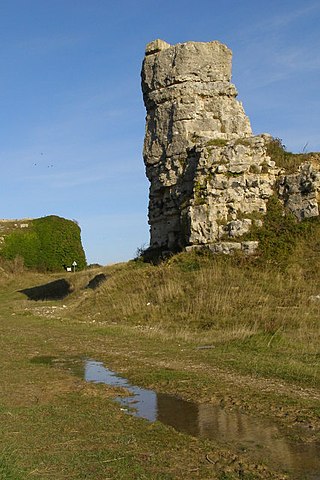
Nicodemus Knob is a 30-feet pillar of Portland stone, left as a landmark and quarrying relic at East Cliff on the Isle of Portland, Dorset, England. A similar artificial pillar formed through quarrying is Pulpit Rock at Portland Bill.

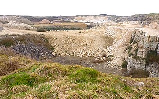
King Barrow Quarry is a disused site of former 19th century stone quarries on the Isle of Portland, Dorset, England. It is located in the north-east corner of Tophill. The quarry, now a Dorset Wildlife Trust nature reserve, covers 12.2 hectares. Both King Barrow and the nearby Tout Quarry make up the Dorset Wildlife Trust's Portland Quarries Nature Park. Portland also has two butterfly reserves: Broadcroft Quarry and Perryfield Quarry.

Mutton Cove is a cove, located on the Isle of Portland, Dorset, England; part of the Jurassic Coast. It is found on the west side of Portland. Presumably named after the once-famous Portland sheep, the cove is an erosional indentation just south of the promontory of Blacknor. On the cliff tops of the cove is part of the South West Coast Path and further south is Wallsend Cove and Portland Bill.

Wallsend Cove is a cove, located on the Isle of Portland, Dorset, England; part of the Jurassic Coast. It is found on the west side of Portland, further south from Mutton Cove, and situated between Southwell Business Park and Portland Bill. The cliff tops above the cove are part of the South West Coast Path.

Freshwater Bay is a bay on the east side of the Isle of Portland, Dorset, England, south from Church Ope Cove and between the villages of Wakeham and Southwell. It forms part of the Jurassic Coast.

Culverwell Mesolithic Site is a Mesolithic settlement, located on the Isle of Portland, Dorset, England. It is found in the local area known as Culverwell, along the Portland Bill Road. It is within an area of unspoiled countryside, with no past quarrying. The site is maintained by the Association for Portland Archaeology – a small group dedicated to researching, investigating and excavating on Portland.

Portland Raised Beach refers to small raised beaches on each side of Portland Bill, on the Isle of Portland, part of the Jurassic Coast in Dorset, England. The main one is known as the West Pleistocene Raised Beach; nearby is the East Pleistocene Raised Beach.

NCI Portland Bill is a National Coastwatch Institution (NCI) lookout station on the Isle of Portland, Dorset, England. The station is situated 50 metres above sea level on the cliff edge, half a mile north of the tip of Portland Bill. It is located close to the Old Higher Lighthouse.

Red Crane is a crane on the Isle of Portland, Dorset, England. It is located on the cliff edge at Portland's southerly point, the promontory Portland Bill. It is part of a disused stone loading quay, which is now a scheduled monument.

King's Pier is a 17th-century stone shipping quay, located on the Isle of Portland, Dorset, England; part of the Jurassic Coast. It is found at the boundary point of the land owned by Portland Port Ltd, on the east side of the island within the area of East Weares. To the north of the pier is Balaclava Bay, whilst further south along the coastline are the remains of Folly Pier and Folly Pier Waterworks, East Weare Rifle Range, the two Salt Pans, Little Beach and Durdle Pier respectively. When active, King's Pier was one of the most important stone shipping pier sites.

Merchant's Railway was a horse drawn and cable operated incline railway on the Isle of Portland, Dorset, England, built for the stone trade on the island. It was the earliest railway in Dorset, opening in 1826. The railway ran two miles from many working quarries at the north of Tophill, along the edge of Verne Hill, to a pier at Castletown, from where the Portland stone was shipped. It was in operation from 1826 to 1939. Since becoming disused the original path of the railway has become a popular public footpath.
Yeolands Quarry is a disused stone quarry located on the Isle of Portland, Dorset, England. It is located on the eastern side of Portland, where it lies east of the village Easton and south of The Grove village. The quarry is one of the largest on Portland, at 120 feet (37 m) deep, 300 feet (91 m) wide. It is now abandoned for extracting stone, though the adjacent Broadcroft Quarry to the west, which links to Yeolands, is still in some use, as well as being a butterfly reserve.

Perryfield Quarry is an operational stone quarry and part butterfly nature reserve located on the Isle of Portland, Dorset, England. It is situated towards the middle of the island, east of the village of Weston and south of the hamlet of Wakeham. The reserve section is now a valued home for a number of butterfly species, while the working quarry area is one of the largest active quarries on Portland. The quarry is owned by Portland Stone Firms Ltd, along with Broadcroft and Coombefield Quarries. The firm is the largest landholder on the island.

