Red Crane, Portland

Last updated

Red Crane Crane, Portland Bill, Dorset (Geograph 2841457 by Chris Talbot).jpg
Red Crane

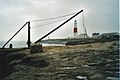
Red Crane is a crane on the Isle of Portland, Dorset, England. It is located on the cliff edge at Portland's southerly point, the promontory Portland Bill. It is part of a disused stone loading quay, which is now a scheduled monument. [1]

Contents

History

The original wooden Red Crane in 1962. The Red Crane on Portland Bill 1962-Geograph-2224310-by-Gordon-Spicer.jpg
The original wooden Red Crane in 1962.

The area of Portland Bill had been quarried during the 19th-century and continued until the early 20th-century. [2] During its commercial years, the stone shipping quay was created as the Bill's prime quay to ship Portland stone off the island. [1] A hand-operated wooden crane was originally erected there for this purpose.

After quarrying ceased in the area in the early 20th century, the quay's crane, which became known as Red Crane, was used to lower fisherman and their boats into the sea. The crane was later replaced by a steel crane, which remains in place today. It continues to be used by fishermen. [3] A similar crane, also steel, is the Broad Ope Crane (also known as Bob's Crane), which is located further north along Portland's east coastline, near Cave Hole. [4] Sandholes Crane, further north of Broad Ope, is a surviving wooden crane.

Related Research Articles

Portland stone Limestone quarried on the Isle of Portland, Dorset, England

Portland Stone or Portland Stone Formation is a limestone formation from the Tithonian stage of the Jurassic period quarried on the Isle of Portland, Dorset, England. The quarries are cut in beds of white-grey limestone separated by chert beds. It has been used extensively as a building stone throughout the British Isles, notably in major public buildings in London such as St Paul's Cathedral and Buckingham Palace. Portland Stone is also exported to many countries—being used for example in the United Nations headquarters building in New York City.

Isle of Portland Human settlement in England

The Isle of Portland is a tied island, 6 kilometres (4 mi) long by 2.7 kilometres (1.7 mi) wide, in the English Channel. Portland is 8 kilometres (5 mi) south of the resort of Weymouth, forming the southernmost point of the county of Dorset, England. A barrier beach called Chesil Beach joins it to the mainland. The A354 road passes down the Portland end of the beach and then over the Fleet Lagoon by bridge to the mainland. The population of Portland is 12,797.

Portland Bill

Portland Bill is a narrow promontory at the southern end of the Isle of Portland, and the southernmost point of Dorset, England. One of Portland's most popular destinations is Portland Bill Lighthouse. Portland's coast has been notorious for the number of shipwrecked vessels over the centuries. The dangerous coastline features shallow reefs and the Shambles sandbank, made more hazardous due to the strong Portland tidal race.

Wakeham Human settlement in England

Wakeham is a hamlet near the village of Easton, in Tophill on the Isle of Portland in Dorset, England. It is situated between the Straits part of Easton, and Pennsylvania Castle. As with the rest of Portland's villages and settlements, Wakeham has been designated as a conservation area, as it is a place of special architectural and historic interest. Easton, Wakeham and Reforne were designated pre-1974. The hamlet features a distinctively wide road running through it, once built to allow space for horse-drawn carts transporting stone by road. Many of Wakeham's older buildings of the 17th and 18th century survive.

Church Ope Cove

Church Ope Cove is a small secluded beach on the sheltered eastern side of the Isle of Portland in Dorset, southern England and is part of the Jurassic Coast. It is found close to the village of Wakeham. The beach has many unusual features for the Isle of Portland. The beach used to be sandy, but quarry debris now covers the sand, and has been worn into rounded pebbles. The pebbles cover a small stream which runs to the sea, which is one of the few active streams remaining on the Isle of Portland.

Pulpit Rock, Portland

Pulpit Rock is a coastal feature at Portland Bill, the southern tip of the Isle of Portland, Dorset, England. Representing an open bible leaning on a pulpit, Pulpit Rock was formed in the 1870s after a natural arch was cut away by quarrymen at Bill Quarry. As a quarrying relic, the rock is similar to that of Nicodemus Knob, another quarrying landmark on the island.

Chiswell Human settlement in England

Chiswell, sometimes, is a small village at the southern end of Chesil Beach, in Underhill, on the Isle of Portland in Dorset. It is the oldest settlement on the island, having formerly been known as Chesilton. The small bay at Chiswell is called Chesil Cove, and the beach promenade and sea wall which form Chiswell's coastal defences are a prominent feature.

Tilly Whim Caves Caves in Dorset, England

Tilly Whim Caves consists of three stone quarries in Durlston Country Park, 1 mile (1.6 km) south of Swanage, on the Isle of Purbeck, in Dorset, southern England. The Tilly Whim Caves are a part of the Jurassic Coast.

Hallelujah Bay A bay in United Kingdom

Hallelujah Bay is a bay located on the west side of the Isle of Portland, Dorset, England. The bay is situated below West Weares, with Clay Ope, Blacknor Point and Mutton Cove further south. Near the cove is a large mound of rock and earth beneath the clifftops known locally as the Green Hump.

Nicodemus Knob

Nicodemus Knob is a 30-feet pillar of Portland stone, left as a landmark and quarrying relic at East Cliff on the Isle of Portland, Dorset, England. A similar artificial pillar formed through quarrying is Pulpit Rock at Portland Bill.

King Barrow Quarry

King Barrow Quarry is a disused site of former 19th century stone quarries on the Isle of Portland, Dorset, England. It is located in the north-east corner of Tophill. The quarry, now a Dorset Wildlife Trust nature reserve, covers 12.2 hectares. Both King Barrow and the nearby Tout Quarry make up the Dorset Wildlife Trust's Portland Quarries Nature Park. Portland also has two butterfly reserves: Broadcroft Quarry and Perryfield Quarry.

Durdle Pier

Durdle Pier is a disused 17th-century stone shipping quay, located on the Isle of Portland, Dorset, England; part of the Jurassic Coast. It is found close by Yeolands Quarry, on the east side of the island within the area of East Weares and Penn's Weare.

Mutton Cove, Portland

Mutton Cove is a cove, located on the Isle of Portland, Dorset, England; part of the Jurassic Coast. It is found on the west side of Portland. Presumably named after the once-famous Portland sheep, the cove is an erosional indentation just south of the promontory of Blacknor. On the cliff tops of the cove is part of the South West Coast Path and further south is Wallsend Cove and Portland Bill.

Cave Hole, Portland

Cave Hole is a large cave on the south east side of the Isle of Portland, a large peninsular in Dorset, England. It has a blowhole and a wooden crane, known as Broad Ope Crane on the cliff top. It is 12 mile (800 m) north-east of Portland Bill, has an interior measuring 50 feet (15 m) square and 21 feet (6.4 m) high.

Portland Raised Beach

Portland Raised Beach refers to small raised beaches on each side of Portland Bill, on the Isle of Portland, part of the Jurassic Coast in Dorset, England. The main one is known as the West Pleistocene Raised Beach; nearby is the East Pleistocene Raised Beach.

Great Southwell Landslip

The Great Southwell Landslip occurred in 1734 on the Isle of Portland, Dorset, England near the southerly village of Southwell and extended for a length of 1.5 miles (2.4 km) between Durdle Pier and Freshwater Bay. It remains Britain's second largest recorded historical landslide.

Kings Pier

King's Pier is a 17th-century stone shipping quay, located on the Isle of Portland, Dorset, England; part of the Jurassic Coast. It is found at the boundary point of the land owned by Portland Port Ltd, on the east side of the island within the area of East Weares. To the north of the pier is Balaclava Bay, whilst further south along the coastline are the remains of Folly Pier and Folly Pier Waterworks, East Weare Rifle Range, the two Salt Pans, Little Beach and Durdle Pier respectively. When active, King's Pier was one of the most important stone shipping pier sites.

Folly Pier

Folly Pier is a disused stone shipping quay, located on the Isle of Portland, Dorset, England; part of the Jurassic Coast. It is found on the east side of the island within the area of East Weares. Other piers within the area include King's Pier and Durdle Pier respectively. Folly Pier dates from the 17th century.

Grove Lime Kiln Historical industrial site in Dorset, England

Grove Lime Kiln is a disused 19th century lime kiln on the Isle of Portland, Dorset, England. It is located close to HM Prison Portland and The Grove village. Owned by the prison service, the lime kiln has been Grade II Listed since 2009.

Yeolands Quarry

Yeolands Quarry was an active stone quarry located on the Isle of Portland, Dorset, England. It is located on the eastern side of Portland, where it lies east of the village Easton and south of The Grove village. The quarry is one of the largest on Portland, at 120 feet (37 m) deep, 300 feet (91 m) wide. It is now abandoned for extracting stone, though the adjacent Broadcroft Quarry to the west, which links to Yeolands, is still in some use, as well as being a butterfly reserve.

References

  1. 1 2 Historic England. "Details from listed building database (1002388)". National Heritage List for England . Retrieved 10 February 2014.
  2. "Portland Bill and Sandholes - Geological Field Guide (new version 18th June 2017)". Southampton.ac.uk. Retrieved 26 October 2017.
  3. "Portland Bill, Portland, Dorset". Geoffkirby.co.uk. Retrieved 10 February 2014.
  4. "Portland Bill - Geological Field Guide". Southampton.ac.uk. Retrieved 10 February 2014.

Coordinates: 50°30′55″N2°27′11″W / 50.5152°N 2.4531°W / 50.5152; -2.4531