
Flamborough Head is a promontory, 8 miles (13 km) long on the Yorkshire coast of England, between the Filey and Bridlington bays of the North Sea. It is a chalk headland, with sheer white cliffs. The cliff top has two standing lighthouse towers, the oldest dating from 1669 and Flamborough Head Lighthouse built in 1806. The older lighthouse was designated a Grade II* listed building in 1952 and is now recorded in the National Heritage List for England, maintained by Historic England. The cliffs provide nesting sites for many thousands of seabirds, and are of international significance for their geology.

White Nothe is a chalk headland on the English Channel coast at the eastern end of Ringstead Bay, east of Weymouth in Dorset, England. The area is well known for its geology and fossils. Its flanks are the result of prehistoric landslides and the inaccessible slopes of the undercliff provide a secluded wildlife habitat.
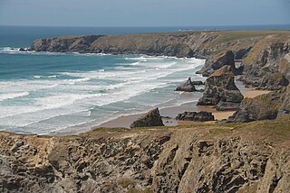
Carnewas and Bedruthan Steps is a stretch of coastline located on the north Cornish coast between Padstow and Newquay, in Cornwall, England, United Kingdom. It is within the parish of St Eval and is part-owned by the National Trust. The trust maintains a shop and café, and the cliff–top views of rocks stretching into the distance along Bedruthan beach make the area a popular attraction for tourists and painters. The property affords walks along the coast path and the steep steps at Bedruthan allow access to a series of rocky beaches at low tide. Signs at the top of the steps down to the beaches warn visitors not to risk swimming in these waters due to heavy rips, fast tides, and submerged rocks.

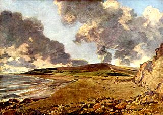
Ringstead is a small seaside village located on the coast in Dorset, southern England. The area lies on the Jurassic Coast and is known for its natural environment and fossils. Ringstead Bay and White Nothe are to the east. Bran Point and Osmington Mills are to the west.
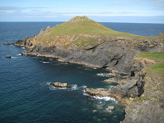
The Rumps is a twin-headland promontory at the north-east corner of Pentire Head in north Cornwall, England, United Kingdom.

Bowleaze Cove is a small sand and shingle beach, near the village of Preston, just to the northeast of Weymouth, Dorset, England. The cove is on the Jurassic Coast and is known for its geology. Just to the west is Furzy Cliff.

Osmington Mills is a coastal hamlet in the English county of Dorset. It lies within the civil parish of Osmington 5 miles (8.0 km) northeast of Weymouth.

Bran Point is a small headland on the Dorset coast in southern England, about halfway between the small villages of Ringstead to the east and Osmington Mills to the west. There is a picturesque cliff-top path between the two villages via Bran Point.

Bat's Head is a chalk headland on the Dorset coast in southern England, located between Swyre Head and Durdle Door to the east, and Chaldon Hill and White Nothe to the west. At the base of the headland is the small Bat's Cave.

Gurnard's Head is a prominent headland on the north coast of the Penwith peninsula in Cornwall, England. The name is supposed to reflect that the rocky peninsula resembles the head of the gurnard fish.
Trevose Head is a headland on the Atlantic coast of north Cornwall, on the south-western coast of Great Britain. It is situated approximately 5 miles (8.0 km) west of Padstow. The South West Coast Path runs around the whole promontory and is within the Cornwall Area of Outstanding Natural Beauty and the Trevose Head Heritage Coast. In clear weather, visitors to Trevose Head can see virtually the whole length of the north Cornwall coast; to the north, the view extends beyond the Cornwall county boundary to Hartland Point, Devon; to the south, it extends beyond St Ives to the headland at Pendeen Watch.
Redcliff Point is on the south coast of England, to the east of Weymouth in Dorset. It lies just past the eastern end of the sweeping Weymouth Bay on the Jurassic Coast, a UNESCO World Heritage landscape known for its geology. Fossils can be found in the Upper Oxford Clay in this area.
Jordan Hill is located near the coast close to the village of Preston, just to the east of Weymouth, Dorset, England. The hill leads down to Furzy Cliff on the coast to the south. Close by to the east is Bowleaze Cove. The hill figure of the Osmington White Horse can be seen from the hill to the north. There are also views across Bowleaze Cove from the hill and nearby public footpaths. The hill is a short detour from the South West Coastal Path National Trail.
Furzy Cliff, also known as Jordan's Cliff, is located on the coast near the village of Preston, just to the east of Weymouth in Dorset, England. It is at the north-eastern end of Weymouth Beach, looking out over Weymouth Bay to Portland Harbour and the Isle of Portland. Close by to the east is Bowleaze Cove. Just inland to the north are Jordan Hill and the remains of the Jordan Hill Roman Temple. On the top of the cliff there is a large grass area with good views.
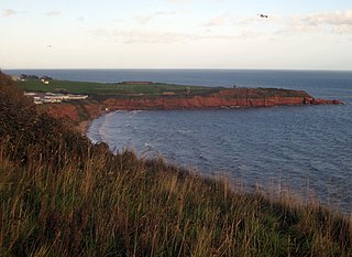
Straight Point is a coastal region, forming a headland, between Exmouth and Budleigh Salterton in Devon on the south coast of England.

West Ringstead is a deserted medieval village located on the coast in Dorset, southern England. The village lies on the Jurassic Coast and is located west of the modern village of Ringstead.


