The Jurassic Coast is a World Heritage Site on the English Channel coast of southern England. It stretches from Exmouth in East Devon to Studland Bay in Dorset, a distance of about 96 miles (154 km), and was inscribed on the World Heritage List in mid-December 2001.

The South West Coast Path is England's longest waymarked long-distance footpath and a National Trail. It stretches for 630 miles (1,014 km), running from Minehead in Somerset, along the coasts of Devon and Cornwall, to Poole Harbour in Dorset. Because it rises and falls with every river mouth, it is also one of the more challenging trails. The total height climbed has been calculated to be 114,931 ft (35,031 m), almost four times the height of Mount Everest. It has been voted 'Britain's Best Walking route' twice in a row by readers of The Ramblers' Walk magazine, and regularly features in lists of the world's best walks.

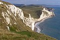
Durdle Door is a natural limestone arch on the Jurassic Coast near Lulworth in Dorset, England. Although privately owned by the Lulworth Estate, it is open to the public.

Dorset is a county in South West England on the English Channel coast. Covering an area of 2,653 square kilometres (1,024 sq mi); it borders Devon to the west, Somerset to the north-west, Wiltshire to the north-east, and Hampshire to the east. The great variation in its landscape owes much to the underlying geology, which includes an almost unbroken sequence of rocks from 200 to 40 million years ago (Mya) and superficial deposits from 2 Mya to the present. In general, the oldest rocks appear in the far west of the county, with the most recent (Eocene) in the far east. Jurassic rocks also underlie the Blackmore Vale and comprise much of the coastal cliff in the west and south of the county; although younger Cretaceous rocks crown some of the highpoints in the west, they are mainly to be found in the centre and east of the county.

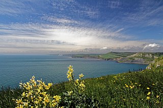
Ringstead Bay, with the small village of Ringstead at the eastern end and the prominent headland of White Nothe at the western end, is located on the coast in Dorset, southern England. The area lies on the Jurassic Coast and is known for its natural environment and fossils.
The Undercliff is the name of several areas of landslip on the south coast of England. They include ones on the Isle of Wight; on the Dorset-Devon border near Lyme Regis; on cliffs near Branscombe in East Devon; and at White Nothe, Dorset. All arose from slump of harder strata over softer clay, giving rise to irregular landscapes of peaks, gullies and slipped blocks, that have become densely vegetated due to their isolation and change of land use. The Kent coast at Folkestone and Sandgate also has similar undercliff areas.

Ringstead is a small village located on the coast in Dorset, southern England. The area lies on the Jurassic Coast and is known for its natural environment and fossils. Ringstead Bay and White Nothe are to the east. Bran Point and Osmington Mills are to the west.

Bowleaze Cove is a small sand and shingle beach, near the village of Preston, just to the northeast of Weymouth, Dorset, England. The cove is on the Jurassic Coast and is known for its geology. Just to the west is Furzy Cliff.

Bran Point is a small headland on the Dorset coast in southern England, about halfway between the small villages of Ringstead to the east and Osmington Mills to the west. There is a picturesque cliff-top path between the two villages via Bran Point.

Bat's Head is a chalk headland on the Dorset coast in southern England, located between Swyre Head and Durdle Door to the east, and Chaldon Hill and White Nothe to the west. At the base of the headland is the small Bat's Cave.

Man o' War Cove lies on the Dorset coast in southern England and is flanked by the rocky, steep and slightly projecting headlands of Durdle Door to the west and Man O War Head to the east.

Kimmeridge Bay is a bay on the Isle of Purbeck, a peninsula on the English Channel coast in Dorset, England, close to and southeast of the village of Kimmeridge, on the Smedmore Estate. The area is renowned for its fossils, with The Etches Collection in the village of Kimmeridge displaying fossils found by Steve Etches in the area over a 30-year period. It is a popular place to access the coast for tourists. To the east are the Kimmeridge Ledges, where fossils can be found in the flat clay beds.

Redcliff Point is on the south coast of England, to the east of Weymouth in Dorset. It lies just past the eastern end of the sweeping Weymouth Bay on the Jurassic Coast, a UNESCO World Heritage landscape known for its geology. Fossils can be found in the Upper Oxford Clay in this area.

Black Head a headland on the south coast of England, to the east of Weymouth in Dorset. It lies on the Jurassic Coast, a UNESCO World Heritage landscape known for its geology. Fossils can be found in the area.

St Oswald's Bay is located near Lulworth on the Jurassic Coast in Dorset, England.

Dungy Head is a coastal promontory located west of Lulworth Cove on the Jurassic Coast in Dorset, England. It forms the eastern end of St Oswald's Bay. It is composed of Portland stone strata. The surrounding area is popular for coastal walks, which yield impressive views. Cliff-climbing however is dangerous and not recommended.

Chaldon Hill, also called Chaldon Down, is one of the highest hills, 178 metres (584 ft), on South Dorset's Jurassic Coast in England. The summit is about 1.5 miles (2.4 km) west of Durdle Door.

West Ringstead is a deserted medieval village located on the coast in Dorset, southern England. The village lies on the Jurassic Coast and is located west of the modern village of Ringstead.

Burning Cliff is a cliff under the White Nothe headland at the eastern end of Ringstead Bay, in Dorset, England. The area is well known for its geology and fossils.