Ringstead, Dorset

Last updated

Ringstead
Village
Ringstead, beach notices - geograph.org.uk - 1416605.jpg
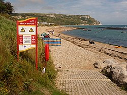
Looking east on the beach at Ringstead with White Nothe in the background
Dorset UK location map.svg
Red pog.svg
Ringstead
Coordinates: 50°37′55″N2°21′17″W / 50.63197°N 2.35465°W / 50.63197; -2.35465
Ordnance Survey
Country England, United Kingdom
County Dorset

Ringstead is a small seaside village located on the coast in Dorset, southern England. The area lies on the Jurassic Coast and is known for its natural environment and fossils. [1] Ringstead Bay and White Nothe are to the east. Bran Point and Osmington Mills are to the west.

Contents

Beach

Ringstead has a pebble and shingle beach with some sand at the western end of Ringstead Bay. [2] [3] There are offshore reefs approximately 0.6 kilometres (0.37 mi) in length opposite the beach at Ringstead that are uncovered at low tide. These form an intertidal zone between the low cliffs to the north and the English Channel to the south.

West Ringstead

The original medieval village [4] and church [5] at Ringstead, located in a field to the west of the current settlement and mentioned in the Domesday Book, no longer exists. [6] It was most likely abandoned after the arrival of the Black Death at Weymouth in 1348. [7] All that can be seen now are variations in the ground level. [5] The site is listed on the National Heritage List for England. [4]

Modern Ringstead

1970 view of West Ringstead from White Nothe, with Ringstead Bay in the foreground and the two radar masts of RAF Ringsteadin the distance Ringstead Bay c.1970.jpg
1970 view of West Ringstead from White Nothe, with Ringstead Bay in the foreground and the two radar masts of RAF Ringsteadin the distance

The modern village of Ringstead is located to the west of the original abandoned village, with a few former fishermen's cottages and holiday homes. [6] The beach, although mostly shingle, is popular with holidaymakers. During World War II and the Cold War, a radar station, known as RAF Ringstead, was located at Ringstead.

Location

Immediately to the east are Ringstead Bay, Burning Cliff, and beyond that the white chalk cliffs of White Nothe, dominating the view. It is possible to walk to the top of White Nothe and back from the village, with views of the bay and across to the Isle of Portland. [8] It is also possible to walk to Ringstead Bay on a circular walk from Lulworth Cove to the east, via Durdle Door and White Nothe. [9]

The small village of Osmington Mills lies on the coast about 1.5 kilometres (0.93 mi) to the west and there is a footpath along the cliffs, via Bran Point. [10] [11] Perry Ledge is a reef off the beach near Bran Point. The large town of Weymouth is situated approximately 8 kilometres (5 mi) west of Ringstead Bay.

Ringstead also has a nudist beach that is a 20-minutes walk east of the main beach. [12] [13]

Access

The beach cafe next to the car park at Ringstead Beach cafe, Ringstead - geograph.org.uk - 3048777.jpg
The beach cafe next to the car park at Ringstead

Ringstead is accessible by way of a private road with a car park and shop/cafe at the end near the sea just before the village itself. There is an alternative free car park in the National Trust area further inland, with footpath access to the sea via a 15–20 minute walk.

See also

Related Research Articles

<span class="mw-page-title-main">Jurassic Coast</span> World Heritage Site on the coast of southern England

The Jurassic Coast is a World Heritage Site on the English Channel coast of southern England. It stretches from Exmouth in East Devon to Studland Bay in Dorset, a distance of about 96 miles (154 km), and was inscribed on the World Heritage List in mid-December 2001.

<span class="mw-page-title-main">South West Coast Path</span> Long-distance footpath in England

<span class="mw-page-title-main">Durdle Door</span> Natural limestone arch on the Jurassic coast of England

Durdle Door is a natural limestone arch on the Jurassic Coast near Lulworth in Dorset, England. It is privately owned by the Weld Family who own the Lulworth Estate, but it is also open to the public.

<span class="mw-page-title-main">Osmington</span> Human settlement in England

Osmington is a village and civil parish within Dorset, England, situated on the Jurassic Coast 4 miles (6.4 km) north-east of Weymouth. In the 2011 census the parish—which includes the small settlements of Upton, Ringstead and Osmington Mills—had a population of 673.

<span class="mw-page-title-main">Ringstead Bay</span>

Ringstead Bay, with the small village of Ringstead at the eastern end and the prominent headland of White Nothe at the western end, is located on the coast in Dorset, southern England. The area lies on the Jurassic Coast and is known for its natural environment and fossils.

<span class="mw-page-title-main">White Nothe</span> Headland in Dorset, England

White Nothe is a chalk headland on the English Channel coast at the eastern end of Ringstead Bay, east of Weymouth in Dorset, England. The area is well known for its geology and fossils. Its flanks are the result of prehistoric landslides and the inaccessible slopes of the undercliff provide a secluded wildlife habitat.

<span class="mw-page-title-main">Bowleaze Cove</span>

Bowleaze Cove is a small sand and shingle beach, near the village of Preston, just to the northeast of Weymouth, Dorset, England. The cove is on the Jurassic Coast and is known for its geology. Just to the west is Furzy Cliff.

<span class="mw-page-title-main">Osmington Mills</span> Human settlement in England

Osmington Mills is a coastal hamlet in the English county of Dorset. It lies within the civil parish of Osmington 5 miles (8.0 km) northeast of Weymouth.

<span class="mw-page-title-main">Bran Point</span>

Bran Point is a small headland on the Dorset coast in southern England, about halfway between the small villages of Ringstead to the east and Osmington Mills to the west. There is a picturesque cliff-top path between the two villages via Bran Point.

<span class="mw-page-title-main">Bat's Head</span> Chalk headland in Dorset, England

Bat's Head is a chalk headland on the Dorset coast in southern England, located between Swyre Head and Durdle Door to the east, and Chaldon Hill and White Nothe to the west. At the base of the headland is the small Bat's Cave.

<span class="mw-page-title-main">Redcliff Point</span>

Redcliff Point is on the south coast of England, to the east of Weymouth in Dorset. It lies just past the eastern end of the sweeping Weymouth Bay on the Jurassic Coast, a UNESCO World Heritage landscape known for its geology. Fossils can be found in the Upper Oxford Clay in this area.

<span class="mw-page-title-main">Black Head, Dorset</span>

Black Head a headland on the south coast of England, to the east of Weymouth in Dorset. It lies on the Jurassic Coast, a UNESCO World Heritage landscape known for its geology. Fossils can be found in the area.

<span class="mw-page-title-main">Swyre Head, Lulworth</span>

Swyre Head, Lulworth is a hill and sea cliff which lies on the Jurassic Coast between Bat's Head to the west and Durdle Door to the east, close to Lulworth in Dorset, England. It is located approximately 8 miles (12.9 km) east of Weymouth and 14 miles (22.5 km) west of Swanage.

<span class="mw-page-title-main">St Oswald's Bay</span>

St Oswald's Bay is located near Lulworth on the Jurassic Coast in Dorset, England.

<span class="mw-page-title-main">Jordan Hill, Dorset</span>

Jordan Hill is located near the coast close to the village of Preston, just to the east of Weymouth, Dorset, England. The hill leads down to Furzy Cliff on the coast to the south. Close by to the east is Bowleaze Cove. The hill figure of the Osmington White Horse can be seen from the hill to the north. There are also views across Bowleaze Cove from the hill and nearby public footpaths. The hill is a short detour from the South West Coastal Path National Trail.

<span class="mw-page-title-main">Jurassic Skyline</span>

The Jurassic Skyline tower was an observation tower on Weymouth Pier in Weymouth, Dorset, England. It was situated next to Weymouth Beach and the Weymouth Pavilion, where it overlooked Weymouth town, the beach, the Pavilion, the Old Harbour, Nothe Gardens, the Nothe Fort, and Portland Harbour. It opened on 22 June 2012.

<span class="mw-page-title-main">West Ringstead</span> Deserted medieval village in Dorset, England

West Ringstead is a deserted medieval village located on the coast in Dorset, southern England. The village lies on the Jurassic Coast and is located west of the modern village of Ringstead.

<span class="mw-page-title-main">River Jordan, Dorset</span> River in Dorset, England

The River Jordan is a river in the county of Dorset, England. The river is approximately 3 miles (4.8 km) long, and includes the tributaries of the Osmington Brook and the Preston River. The River Jordan discharges into the English Channel at Bowleaze Cove, northeast of Weymouth.

<span class="mw-page-title-main">Burning Cliff</span> Cliff in Dorset, England

Burning Cliff is a cliff under the White Nothe headland at the eastern end of Ringstead Bay, in Dorset, England. The area is well known for its geology and fossils.

References

  1. "Ringstead Bay". UK: National Trust . Retrieved 16 January 2022.
  2. "Ringstead Bay". thebeachguide. UK. Retrieved 16 January 2022.
  3. "Ringstead Beach". Visit Dorset. UK. Retrieved 16 January 2022.
  4. 1 2 "Medieval settlement at West Ringstead". UK: Historic England . Retrieved 22 January 2022.
  5. 1 2 "Ringstead (deserted village)". dorset-churches.org.uk. UK. Retrieved 22 January 2022.
  6. 1 2 Ashley, Harry (1984). "Ringstead". The Dorset Village Book. Newbury: Countryside Books. pp. 120–121. ISBN   0 905392 35 3.
  7. "Ringstead". www.jurassiccoastline.com. Jurassic Coastline. Archived from the original on 10 November 2013. Retrieved 10 November 2013.
  8. West, Ian. "Ringstead Bay to White Nothe, Dorset". Geology of the Wessex Coast of Southern England. UK: University of Southampton . Retrieved 10 November 2013.
  9. Durdle Door & White Nothe circular, The South West Coast Path National Trail, UK.
  10. West, Ian. "Osmington Mills to Ringstead Bay — Corallian Strata". Geology of the Wessex Coast of Southern England. UK: University of Southampton. Retrieved 10 November 2013.
  11. Osmington, Osmington Mills and Ringstead, Dorset, UK.
  12. "Ringstead Bay Dorset". Naturist / Nudist Beaches in England, Scotland, Wales and Ireland. UK: Saturday Walkers Club. Retrieved 16 January 2022.
  13. "Ringstead Bay news from the Dorset Beaches". dorsetbeaches.co.uk. Archived from the original on 26 May 2015. Retrieved 16 August 2015.