
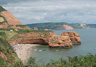
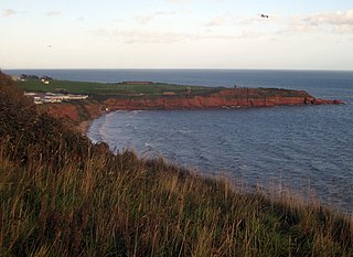
Straight Point is a coastal region, forming a headland, between Exmouth and Budleigh Salterton in Devon on the south coast of England.
Straight Point is a coastal region, forming a headland, between Exmouth and Budleigh Salterton in Devon on the south coast of England.
Straight Point is about 16 kilometres (9.9 mi) south of the city of Exeter, 4 kilometres (2.5 mi) southeast of Exmouth and about 11 kilometres (6.8 mi) southwest of Sidmouth.
The top of the headland is used by the Royal Marines as a firing range, [1] [2] established using emergency powers during the second world war. [3] To the west is Sandy Bay, a holiday beach, that can be reached either along the coastal path or through the large caravan park. To the east are Otter Cove and Littleton Cove. A navigational light for shipping was established on Straight Point in 1950 due the difficult conditions in the area for ships approaching the coast. [4]
The red sandstone cliffs at Straight Point show a sequence of sandstones in the Exmouth Formation. Predominantly the cliffs are composed of layers of Aylesbeare Mudstone, including some sandstone layers. They represent the earliest geology along the entire coast. [5] They are from the Triassic period and date from 250 million years ago. [5] Both sediments are markedly red, which indicates that they were formed in a desert.
At the east is an erosional platform, abraded by quartzite pebbles from the Budleigh Salterton pebble bed, seen at the neighbouring Littleham Cove. [6]
At low tide most of the western section is accessible at low tide from Sandy Bay, but only a small part of the eastern side.

The Jurassic Coast is a World Heritage Site on the English Channel coast of southern England. It stretches from Exmouth in East Devon to Studland Bay in Dorset, a distance of about 96 miles (154 km), and was inscribed on the World Heritage List in mid-December 2001.

The South West Coast Path is England's longest waymarked long-distance footpath and a National Trail. It stretches for 630 miles (1,014 km), running from Minehead in Somerset, along the coasts of Devon and Cornwall, to Poole Harbour in Dorset. Because it rises and falls with every river mouth, it is also one of the more challenging trails. The total height climbed has been calculated to be 114,931 ft (35,031 m), almost four times the height of Mount Everest. It has been voted 'Britain's Best Walking route' twice in a row by readers of The Ramblers' Walk magazine, and regularly features in lists of the world's best walks.

Budleigh Salterton is a seaside town on the coast in East Devon, England, 15 miles (24 km) south-east of Exeter. It lies within the East Devon Area of Outstanding Natural Beauty, and forms much of the electoral ward of Budleigh, whose ward population at the 2021 census was 7,671.

Exmouth is a port town, civil parish and seaside resort situated on the east bank of the mouth of the River Exe, 11 miles (18 km) southeast of Exeter.

Ringstead Bay, with the small village of Ringstead at the eastern end and the prominent headland of White Nothe at the western end, is located on the coast in Dorset, southern England. The area lies on the Jurassic Coast and is known for its natural environment and fossils.

East Devon was a UK parliamentary constituency, represented most recently in the House of Commons of the UK Parliament by Simon Jupp of the Conservative Party.

Lyme Bay is an area of the English Channel off the south coast of England. The south western counties of Devon and Dorset front onto the bay.

Exmouth railway station serves the town of Exmouth in Devon, England and is 11.25 miles (18 km) south of Exeter St Davids, the terminus of the Avocet Line. The station is managed by Great Western Railway, who operate all trains serving it.
Ladram Bay is a secluded bay with a pebble beach, on the south coast of Devon, England between the coastal towns of Budleigh Salterton and Sidmouth. It is about 11 miles southeast of Exeter, just under 2 mi (3 km) southwest of Sidmouth and about 2+1⁄2 miles (4 km) northeast of Budleigh Salterton.
Orcombe Point is a coastal feature near Exmouth, Devon, on the south coast of England. It lies about 10 mi (16 km) south of the city of Exeter, 2 mi (3.2 km) southeast of Exmouth town centre and about 7.5 mi (12.1 km) southwest of Sidmouth.

Bindon Hill is an extensive Iron Age earthwork enclosing a coastal hill area on the Jurassic Coast near Lulworth Cove in Dorset, England, about 19 kilometres (12 mi) west of Swanage, about 6 kilometres (3.7 mi) south west of Wareham, and about 17 kilometres (11 mi) south east of Dorchester. It is within an Area of Outstanding Natural Beauty.

Otterton is a village and civil parish in East Devon, England. The parish lies on the English Channel and is surrounded clockwise from the south by the parishes of East Budleigh, Bicton, Colaton Raleigh, Newton Poppleford and Harpford and Sidmouth. In 2001 its population was 700, compared to 622 a hundred years earlier. At the 2011 census the population had reduced to 656. Otterton is part of Raleigh electoral ward whose total population at the above census was 2,120.

Black Head a headland on the south coast of England, to the east of Weymouth in Dorset. It lies on the Jurassic Coast, a UNESCO World Heritage landscape known for its geology. Fossils can be found in the area.
Sandy Bay is a secluded bay with a sand beach, about 1.6 kilometres (0.99 mi) long, in Exmouth, Devon, England. It is a sandy beach with rock pools at one end, backed by high cliffs. It is part of a long strip of sand which is connected to the beach at Exmouth at low tide. Nearby are the Orcombe rocks, which is a famous spot for fossils.

Danger Point is a coastal feature and cliff face in Devon, on the south coast of England. It is about 18 kilometres (11 mi) southeast of the city of Exeter and about 7 kilometres (4.3 mi) east of Exmouth and lies between the towns of Budleigh Salterton and Sidmouth.
Otter Cove is a small secluded cove on the south coast of Devon, England, between the coastal towns of Exmouth and Budleigh Salterton. It is part of the Jurassic Coast World Heritage Site. Due to a landslip the cove is no longer accessible from the headland.

Littleham is an area of Exmouth and former civil parish, now in the parish of Exmouth, in the East Devon district, in the county of Devon, England. It was historically a village, much older than Exmouth itself. In 1961 the parish had a population of 7954. On 1 April 1974 the parish was abolished.

The Aylesbeare Mudstone Group is an early Triassic lithostratigraphic group in southwest England. The name is derived from the village of Aylesbeare in east Devon. The Group comprises the Littleham Mudstone Formation, the Exmouth Mudstone and Sandstone Formation and the underlying Clyst St Lawrence Formation. The strata are exposed on the coast between Exmouth and Budleigh Salterton where the type section is defined. The rocks of the Aylesbeare Mudstone Group have also previously been known as the Aylesbeare Group and the Aylesbeare Mudstone Formation.