West Dorset

Last updated

West Dorset District
Arms of West Dorset District Council.svg
West Dorset UK locator map.svg
West Dorset shown within Dorset
Sovereign state United Kingdom
Constituent country England
Region South West England
Non-metropolitan county Dorset
StatusAbolished
Admin HQ Dorchester
Incorporated1 April 1974
Government
  TypeNon-metropolitan district council
  BodyWest Dorset District Council
  Leadership Leader & Cabinet ( )
   MPs Chris Loder
Area
  Total417.6 sq mi (1,081.5 km2)
  Rank (of 314)
Population
 (2021)
  Rank (of 314)
  Ethnicity
98.7% White
Time zone UTC0 (GMT)
  Summer (DST) UTC+1 (BST)
ONS code 19UH (ONS)
E07000052 (GSS)
OS grid reference SY5785299047
Website www.dorsetforyou.gov.uk

West Dorset was a local government district in Dorset, England. The district was formed on 1 April 1974 under the Local Government Act 1972, and was a merger of the boroughs of Bridport, Dorchester and Lyme Regis, along with Sherborne urban district and the rural districts of Beaminster, Bridport, Dorchester and Sherborne. Its council was based in Dorchester.

Contents

The district and its council were abolished on 1 April 2019 and, together with the other four districts outside the greater Bournemouth area, replaced by a new Dorset unitary authority. [1]

Demography

At the 2001 census, West Dorset registered a population of 92,350. The population structure reflected the rural nature of the district. The area was a popular retirement area which also exported young people due to the lack of career options. This was reflected in the age structure, with 12.3% of the population over 75, compared to 7.5% in the whole of England; 51.7% were between 15 and 59, compared to 59.1% in England. 34.4% of dwellings were pensioner households, compared to 23.8% in England.

The district was an example of the low ethnic minority populations in rural areas, with 96.7% white British ethnicity, compared to 87.0% in England.

The district had a high level of car ownership, at 83.1% of households compared to 73.2% in England.

Westminster constituencies

Almost all of the West Dorset area fell within the West Dorset constituency; a small part was in South Dorset.

Settlements

The main settlements in West Dorset were Dorchester, Sherborne and Bridport. Dorchester, in the south of the district, is the county town of Dorset and has been an important settlement since Roman times. Sherborne, in the north, is an important market town which was, for a time, the capital of Wessex. Bridport, in the west, is popular with tourists visiting the Jurassic Coast, as is the smaller coastal town of Lyme Regis at the county border with Devon.

Settlements with a population over 2,500 are in bold.

Places of interest

Maiden Castle in 1934: photograph by Major George Allen (1891-1940) Maiden Castle from the air, 1934.jpg
Maiden Castle in 1934: photograph by Major George Allen (1891–1940)

See also

Related Research Articles

<span class="mw-page-title-main">Dorset</span> County of England

Dorset is a ceremonial county in South West England. It is bordered by Somerset to the north-west, Wiltshire to the north-east, Hampshire to the east, the English Channel to the south, and Devon to the west. The largest settlement is Bournemouth, and the county town is Dorchester.

<span class="mw-page-title-main">North Dorset</span> Former non-metropolitan district in England

North Dorset was a local government district in Dorset, England, between 1974 and 2019. Its area was largely rural, but included the towns of Blandford Forum, Gillingham, Shaftesbury, Stalbridge and Sturminster Newton. Much of North Dorset was in the River Stour valley, known as the Blackmore Vale. The economy of North Dorset was largely based on dairy agriculture.

<span class="mw-page-title-main">A35 road</span> Major road in southern England

The A35 is a major road in southern England, connecting Honiton in Devon and Southampton in Hampshire. It is a trunk road for some of its length. Most of its route passes through Dorset and the New Forest. It originally connected Exeter and Southampton, the original A35 ran along what is now the A3052 joining the present road at Charmouth.

<span class="mw-page-title-main">Maiden Newton</span> Village in Dorset, England

Maiden Newton is a village and civil parish in the county of Dorset in south-west England. It lies within the Dorset Council administrative area, about 9 miles (14 km) north-west of the county town, Dorchester.

<span class="mw-page-title-main">Rampisham</span> Village in Dorset, England

Rampisham is a village and civil parish in the county of Dorset in southern England, situated approximately 11 miles (18 km) northwest of the county town Dorchester. The village is sited on greensand in a valley surrounded by the chalk hills of the Dorset Downs. The parish includes the hamlet of Uphall northwest of the main village.

<span class="mw-page-title-main">History of Dorset</span> Aspect of history

Dorset is a rural county in south west England. Its archaeology documents much of the history of southern England.

<span class="mw-page-title-main">Hooke, Dorset</span> Human settlement in England

Hooke is a small village and civil parish in the county of Dorset in southern England, situated about 7 miles (11 km) northeast of the town of Bridport. It is sited in the valley of the short River Hooke, a tributary of the River Frome, amongst the chalk hills of the Dorset Downs. In the 2011 census the parish had a population of 157.

<span class="mw-page-title-main">South Dorset (UK Parliament constituency)</span> Parliamentary constituency in the United Kingdom, 1885 onwards

South Dorset is a constituency represented in the House of Commons of the UK Parliament since 2010 by Richard Drax, a Conservative. The constituency was created as a consequence of the Redistribution of Seats Act 1885, although the area covered has changed since then.

<span class="mw-page-title-main">West Dorset (UK Parliament constituency)</span>

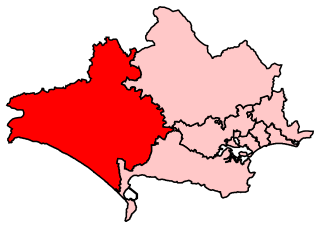
West Dorset is a constituency represented in the House of Commons of the UK Parliament since 2019 by Chris Loder, a Conservative.

The DT postcode area, also known as the Dorchester postcode area, is a group of eleven postcode districts in South West England, within nine post towns. These cover much of Dorset, plus very small parts of Devon and Somerset.

<span class="mw-page-title-main">Transport in Dorset</span>

Dorset is a county in South West England. The county is largely rural and therefore does not have a dense transport network, and is one of the few English counties without a motorway. Owing to its position on the English Channel coast, and its natural sheltered harbours, it has a maritime history, though lack of inland transport routes have led to the decline of its ports.

<span class="mw-page-title-main">Geography of Dorset</span>

Dorset is a county located in the middle of the south coast of England. It lies between the latitudes 50.512°N and 51.081°N and the longitudes 1.682°W and 2.958°W, and occupies an area of 2,653 km2. It spans 90 kilometres (56 mi) from east to west and 63 kilometres (39 mi) from north to south.

<span class="mw-page-title-main">Jurassic Coaster</span>

The Jurassic Coaster is a bus service operated by the Weymouth branch of First Hampshire & Dorset, running around the Jurassic coastline of the county of Dorset. It features five routes, stretching from Axminster in the west to Poole in the east, with one of the routes in TripAdvisor's 2018 poll of most scenic bus routes coming in 12th place.

References

  1. Ministry of Housing, Communities and Local Government (25 May 2018). "The Bournemouth, Dorset and Poole (Structural Changes) Order 2018". legislation.gov.uk. Retrieved 28 May 2018.

50°47′N2°36′W / 50.79°N 2.60°W / 50.79; -2.60