
The River Frome is a river in Dorset in the south of England. At 30 miles (48 km) long it is the major chalkstream in southwest England. It is navigable upstream from Poole Harbour as far as the town of Wareham.

West Dorset was a local government district in Dorset, England. The district was formed on 1 April 1974 under the Local Government Act 1972, and was a merger of the boroughs of Bridport, Dorchester and Lyme Regis, along with Sherborne urban district and the rural districts of Beaminster, Bridport, Dorchester and Sherborne. Its council was based in Dorchester.

Buckland Dinham is a small village near Frome in Somerset, England. The village has a population of 381. The village's main industry is farming, but the village is also a dormitory village for the nearby cities of Bath and Bristol.

Maiden Newton is a village and civil parish in the county of Dorset in south-west England. It lies within the Dorset Council administrative area, about 9 miles (14 km) north-west of the county town, Dorchester.

Puddletown is a village in the civil parish of Athelhampton and Puddletown, in Dorset, England. It is situated by the River Piddle, from which it derives its name, about 4.5 miles (7 km) northeast of the county town Dorchester. Its earlier name Piddletown fell out of favour, probably because of connotations of the word "piddle". The name Puddletown was officially sanctioned in the late 1950s. Puddletown's civil parish covers 2,908 hectares and extends to the River Frome to the south. In 2013, the estimated population of the civil parish was 1450.

Cattistock is a village and civil parish in west Dorset, England, sited in the upper reaches of the Frome Valley, 8 miles (13 km) northwest of the county town Dorchester. The Dorset poet William Barnes called it "elbow-streeted Cattstock", a comment on the less-than-linear village street. In the 2011 census the parish had a population of 509.
Compton Valence is a small village and civil parish in the county of Dorset in southern England. It lies approximately 7 miles (11 km) west of the county town Dorchester. It is sited at the head of a narrow valley, formed by a small tributary of the River Frome, and is surrounded by the hills of the Dorset Downs, which has led to it having been described as "a pocket of habitation in the downs." Dorset County Council estimate that in 2013 the population of the parish was 50.

Dewlish is a village and civil parish in the county of Dorset in southern England, and is situated approximately 7 miles (11 km) north-east of the county town Dorchester. The village is sited in the valley of the small Devil's Brook among the chalk hills of the Dorset Downs; the parish covers about 2,100 acres (850 ha) and extends west to include part of the valley of the small Cheselbourne stream, and east to include a dry valley at Dennet's Bottom. The surrounding area is part of the Dorset National Landscape area. In the 2011 census the parish had a population of 284.

Evershot is a village and civil parish in the county of Dorset in southwest England, situated approximately 7 miles (11 km) south of Yeovil in Somerset. It is the second highest village in the county at 175 metres (574 ft) above sea-level. Evershot parish encompasses part of the nearby hamlet of Holywell, 1.25 miles (2.01 km) east of Evershot village. Dorset County Council's latest (2013) estimate of the parish population is 210. The village has connections with the writer Thomas Hardy.

Frome Vauchurch is a parish in the county of Dorset in southern England, situated approximately 7 miles (11 km) northwest of the county town Dorchester. It includes the hamlets of Frome Vauchurch, Higher Frome Vauchurch, Lower Frome Vauchurch and Tollerford. Frome Vauchurch is sited in the Frome valley amongst the chalk hills of the Dorset Downs. The parish is adjacent to the village of Maiden Newton, with which the parish's hamlets are virtually contiguous. Dorset County Council's latest (2013) estimate of the parish population is 160.

Moreton is a village and civil parish in Dorset, England, situated on the River Frome about 8 miles (13 km) east of Dorchester. In the 2011 census the civil parish had 158 households and a population of 373. It has a number of long distance footpaths and cycle ways passing through it: the Purbeck cycle way, Route 2 (Sustrans), the Frome valley trail, the Jubilee trail, and the Hardy Way. The railway station is a little way out of the village, towards Crossways.

Rampisham is a village and civil parish in the county of Dorset in southern England, situated approximately 11 miles (18 km) northwest of the county town Dorchester. The village is sited on greensand in a valley surrounded by the chalk hills of the Dorset Downs. The parish includes the hamlet of Uphall northwest of the main village.

Stratton is a village and civil parish in Dorset, England, situated in the Frome valley about 3 miles (4.8 km) north-west of Dorchester. The parish includes the hamlets of Grimstone, Ash Hill and Wrackleford which, like the village, lie on or near the A37 trunk road. Ash Hill is a small estate east of the village near the railway. Wrackleford is a group of houses further east and centred about Wrackleford House and including Higher Wrackleford and Lower Wrackleford. In addition there are a number of isolated farms and houses including a few in an area called Langford near the Sydling Water in the north-west part of the parish.

Sydling St Nicholas is a village and civil parish in Dorset within southwest England. The parish is 5 to 9 miles northwest of the county town Dorchester and covers most of the valley of the small Sydling Water in the chalk hills of the Dorset Downs. The parish has an area of 2,075 hectares and includes the hamlet of Up Sydling in the north.

Woodsford is a village and civil parish beside the River Frome, Dorset, England, about 4 miles (6.4 km) east of the county town Dorchester. Dorset County Council's 2013 mid-year estimate of the parish population is 80.

Frampton is a village and civil parish in the county of Dorset in southern England, situated approximately 5 miles (8.0 km) northwest of the county town Dorchester. It is sited in the Frome valley among chalk hills of the Dorset Downs. The village's name is a derivation from "Frome Town".

Poundbury Hill is the site of a scheduled Prehistoric and Roman archaeological remains and includes evidence of a Neolithic settlement, a substantial Bronze Age occupation site and an Iron Age hillfort. There are also late Iron Age burials and a section of Roman aqueduct. On the eastern side is an earlier Romano-British farmstead; and an extensive later cemetery, belonging to the Roman town Durnovaria.

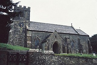
Chilfrome is a small village and civil parish in the county of Dorset in southwest England. It lies in the Dorset unitary authority administrative area, approximately 9 miles (14 km) northwest of the county town Dorchester. It is situated between the villages of Cattistock and Maiden Newton in the upper reaches of the Frome Valley in the Dorset Downs. The parish church was largely restored in 1864, though it has a thirteenth-century chancel-arch, a partly fourteenth-century nave, and windows dating from the fifteenth century. The parish church dates from the 14th century and is a Grade II* Listed Building. Dorset County Council estimate that in 2013 the population of the civil parish was 40.
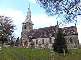
St Mary's Church is a Church of England parish church in Bradford Peverell, Dorset, England. It was designed by Decimus Burton and built in 1849–50. The church is a Grade II* listed building.
The Frome Valley Trail is a long-distance footpath in Dorset, England which follows the River Frome from Evershot to Dorchester and will, when completed, extend to Poole Harbour.

