Verne Heavy Anti-Aircraft Battery

Last updated

One of the four circular 1942 gun emplacements of the Verne HAA Battery. Portland HAA Battery 5.JPG
One of the four circular 1942 gun emplacements of the Verne HAA Battery.

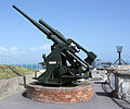
Verne Heavy Anti-Aircraft Battery is a World War II anti-aircraft battery on the Isle of Portland, Dorset, England. It is located on private property in the north-east area of the island, south of the Verne Citadel. The battery became a scheduled monument in March 2019. [1]

Contents

History

During World War II, Portland's naval base was a primary target for German air raids, [2] prompting a number of heavy anti-aircraft batteries to be built within the region, one of which was located close to the Verne Citadel. [3] Locally designated as "Battery B", [4] other nearby batteries included examples at Blackhead near Weymouth, Barrow Hill near Southwell, and Chickerell, Weymouth. [5] [6] [7]

The Verne battery's operated using QF 3.7-inch AA guns. [4] Manned by personnel of AA Command, the battery's associated Gun Operations Room was based at Red Barracks, Weymouth, and from 1941 at Nottington House, Weymouth. The battery was later fitted with GL Mark II radar from 1942. [3] After the war, the battery survived and was put into use as stables. [3]

Related Research Articles

<span class="mw-page-title-main">Chesil Beach</span> Shingle beach in Dorset, England

Chesil Beach in Dorset, England is one of three major shingle beach structures in Britain. Its name is derived from the Old English ceosel or cisel, meaning "gravel" or "shingle". It runs for a length of 29 kilometres (18 mi) from West Bay to the Isle of Portland and in places is up to 15 metres (50 ft) high and 200 metres (660 ft) wide. Behind the beach is the Fleet, a shallow tidal lagoon. Both are part of the Jurassic Coast and a UNESCO World Heritage Site, and together form an SSSI and Ramsar Site.

<span class="mw-page-title-main">Portland Harbour</span> Port in Dorset, England

Portland Harbour is located beside the Isle of Portland, Dorset, on the south coast of England. Construction of the harbour began in 1849; when completed in 1872, its 520-hectare (1,300-acre) surface area made it the largest human-made harbour in the world, and it remains one of the largest in the world today. It is naturally sheltered by Portland to the south, Chesil Beach to the west and mainland Dorset to the north. It consists of four breakwaters: two southern and two northern. These have a total length of 4.57 km (2.84 mi) and enclose approximately 1,000 ha of water.

<span class="mw-page-title-main">Nothe Fort</span> Fort in Weymouth, Dorset, England

Nothe Fort is a fort in Weymouth, Dorset, England, situated at the end of the Nothe Peninsula, which juts eastwards from the town of Weymouth, and Weymouth Harbour, into the sea to the north of the ex-military Portland Harbour. The fort is located next to Nothe Gardens.

<span class="mw-page-title-main">Verne Citadel</span>

Verne Citadel is a 19th-century citadel on the Isle of Portland, Dorset, England. Located on the highest point of Portland, Verne Hill, it sits in a commanding position overlooking Portland Harbour, which it was built to defend. It later became HM Prison The Verne in 1949.

<span class="mw-page-title-main">East Weare Battery</span>

East Weare Battery is a former 19th-century gun battery to the east of the Verne Citadel on the Isle of Portland in Dorset, England. The battery was built in the 1860s as a result of the Royal Commission to guard the new Portland harbour and Royal Navy institutions on the island. Five open batteries were built housing 20 9" and 10" RMLs. After 1877 the batteries were designated by letter 'A' to 'E'.

<span class="mw-page-title-main">Verne High Angle Battery</span>

The Verne High Angle Battery is a former 19th-century gun battery on the Isle of Portland in Dorset, England. Situated close to the Verne Citadel, the battery is Grade II Listed, and forms part of the citadel's scheduled monument status. The battery has become a tourist attraction, while the battery's tunnels are often referred to by their local name 'Ghost Tunnels'.

<span class="mw-page-title-main">Southwell, Dorset</span> Human settlement in England

Southwell is a small coastal village in Tophill on the Isle of Portland, Dorset. As Portland and Dorset's southernmost village, it lies between Portland Bill and the villages of Easton and Weston. Though close to the Bill, the village is sheltered by hills on three sides. It is the only village on Portland not to be designated a conservation area.

<span class="mw-page-title-main">Church Ope Cove</span>

Church Ope Cove is a small secluded beach on the sheltered eastern side of the Isle of Portland in Dorset, southern England, and is part of the Jurassic Coast. It is found close to the village of Wakeham. The beach has many unusual features for the Isle of Portland. The beach used to be sandy, but quarry debris now covers the sand, and has been worn into rounded pebbles. The pebbles cover a small stream which runs to the sea, which is one of the few active streams remaining on the Isle of Portland.

<span class="mw-page-title-main">Stallingborough</span> Human settlement in England

Stallingborough is a village and civil parish in North East Lincolnshire, England. The population of the civil parish at the 2011 census was 1,234.

Bincleaves Groyne is a breakwater located off the southern area of Weymouth, England. It is the second largest of four breakwaters which create Portland Harbour. It is separated from the Northeastern Breakwater by the North Ship Channel. A landing stage is situated on the southern side of the breakwater near the Western Ledges.

<span class="mw-page-title-main">Balaclava Bay</span> Bay in Dorset, England

Balaclava Bay is a bay situated on the edge of Portland Harbour, where the breakwater meets the island, at the northern end of the Isle of Portland, Dorset, in southern England. The bay is overlooked by the Victorian East Weare Battery, built in the 1860s to protect the harbour. The nearest road within the dockyard of Portland Port is named Balaclava Road.

<span class="mw-page-title-main">Nothe Gardens</span>

Nothe Gardens is a public garden, located in Weymouth, Dorset, England. Positioned on the Nothe Peninsula overlooking both Weymouth and Portland harbours, the informal gardens are often acclaimed to be the most beautiful the borough has to offer.

<span class="mw-page-title-main">Durdle Pier</span>

Durdle Pier is a disused 17th-century stone shipping quay, located on the Isle of Portland, Dorset, England; part of the Jurassic Coast. It is found close by Yeolands Quarry, on the east side of the island within the area of East Weares and Penn's Weare.

<span class="mw-page-title-main">Mutton Cove, Portland</span>

Mutton Cove is a cove, located on the Isle of Portland, Dorset, England; part of the Jurassic Coast. It is found on the west side of Portland. Presumably named after the once-famous Portland sheep, the cove is an erosional indentation just south of the promontory of Blacknor. On the cliff tops of the cove is part of the South West Coast Path and further south is Wallsend Cove and Portland Bill.

<span class="mw-page-title-main">East Weare Camp</span>

East Weare Camp is a former 19th-century detention barracks on the Isle of Portland in Dorset, England. It is located at East Weares, overlooking Portland Harbour and East Weare Battery. The camp became Grade II Listed in 1978. Both East Weare Battery and East Weare Camp remain on the private property of Portland Port Ltd, and have not been opened to the public.

<span class="mw-page-title-main">Folly Pier</span> Disused stone shipping quay in Dorset, England

Folly Pier is a disused stone shipping quay, located on the Isle of Portland, Dorset, England; part of the Jurassic Coast. It is found on the east side of the island within the area of East Weares. Other piers within the area include King's Pier and Durdle Pier respectively. Folly Pier dates from the 17th century.

<span class="mw-page-title-main">East Weare Rifle Range</span> Disused rifle range of the Royal Navy on the Isle of Portland, England

East Weare Rifle Range is a disused naval rifle range on the Isle of Portland, Dorset, England. It is located within the area of East Weares, overlooking Portland Harbour. The range became a scheduled monument in October 2015, which included the stop butt of Portland stone, the marker's gallery and 100-yard firing position. It remains on the private property of Portland Port Ltd, and has not been opened to the public, however can be seen from surrounding coastal paths.

<span class="mw-page-title-main">Merchant's Railway</span> Former railway in Dorset, England

Merchant's Railway was a horse drawn and cable operated incline railway on the Isle of Portland, Dorset, England, built for the stone trade on the island. It was the earliest railway in Dorset, opening in 1826. The railway ran two miles from many working quarries at the north of Tophill, along the edge of Verne Hill, to a pier at Castletown, from where the Portland stone was shipped. It was in operation from 1826 to 1939. Since becoming disused the original path of the railway has become a popular public footpath.

<span class="mw-page-title-main">Inner Pierhead Fort</span>

Inner Pierhead Fort is a 19th-century fort built to defend Portland Harbour at the Isle of Portland, Dorset, England. It is positioned on the end of the inner breakwater, which abuts from the former dockyard of HMNB Portland. The fort was constructed between 1859-1862, and is 100 ft in diameter. The inner breakwater, including the fort, became Grade II Listed in 1978.

References

  1. Historic England. "Heavy Anti-Aircraft Battery (P3 Verne), 275m south-west of Fancy's Farm, Portland (1459502)". National Heritage List for England . Retrieved 28 March 2019.
  2. "World War 2". Geoffkirby.co.uk. Retrieved 14 January 2018.
  3. 1 2 3 Pomeroy, Colin A. (1995). Military Dorset Today: Second World War Scenes and Settings That Can Still Be Seen 50 Years on. Silver Link Publishing Ltd. p. 71. ISBN   978-1857940770.
  4. 1 2 Historic England. "Heavy Anti Aircraft Battery Portland B (1413298)". Research records (formerly PastScape). Retrieved 18 September 2014.
  5. Historic England. "Monument No. 1413309". Research records (formerly PastScape). Retrieved 3 October 2015.
  6. Historic England. "Heavy Anti Aircraft Battery Portland D (1413228)". Research records (formerly PastScape). Retrieved 18 September 2014.
  7. Historic England. "HEAVY ANTI AIRCRAFT BATTERY PORTLAND 5 (1473260)". Research records (formerly PastScape). Retrieved 26 June 2014.

50°33′24″N2°26′04″W / 50.5566°N 2.4344°W / 50.5566; -2.4344