
Portland Harbour is located beside the Isle of Portland, Dorset, on the south coast of England. Construction of the harbour began in 1849; when completed in 1872, its 520-hectare (1,300-acre) surface area made it the largest human-made harbour in the world, and it remains one of the largest in the world today. It is naturally sheltered by Portland to the south, Chesil Beach to the west and mainland Dorset to the north. It consists of four breakwaters: two southern and two northern. These have a total length of 4.57 km (2.84 mi) and enclose approximately 1,000 ha of water.
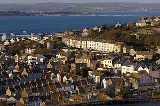
Fortuneswell is a village in Underhill on the Isle of Portland, in Dorset, England. It lies on steeply sloping land on the northern edge of the island, known as Underhill, where Chesil Beach connects the island to the mainland. Adjoining Fortuneswell are Chiswell to the west and Castletown to the north. Fortuneswell occupies the steeper land above sea level, whereas Chiswell and Castletown occupy flat land close to sea level, next to Chesil Beach and Portland Harbour respectively. Fortuneswell has a main shopping street, and along with Easton, is the main hub of the island's activities.
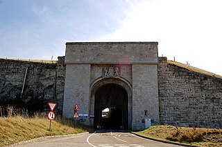
Verne Citadel is a 19th-century citadel on the Isle of Portland, Dorset, England. Located on the highest point of Portland, Verne Hill, it sits in a commanding position overlooking Portland Harbour, which it was built to defend. It later became HM Prison The Verne in 1949.

The Verne High Angle Battery is a former 19th-century gun battery on the Isle of Portland in Dorset, England. Situated close to the Verne Citadel, the battery is Grade II Listed, and forms part of the citadel's scheduled monument status. The battery has become a tourist attraction, while the battery's tunnels are often referred to by their local name 'Ghost Tunnels'.
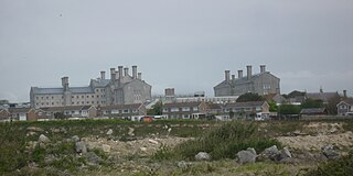
HM Prison The Verne is a Category C men's prison located within the historic Verne Citadel on the Isle of Portland in Dorset, England. Operated by His Majesty's Prison Service, HMP The Verne was established in 1949 and occupies the southern part of the citadel. After a brief spell as an Immigration Removal Centre in 2014–2017, HMP The Verne re-opened in 2018.

Castletown is a small village in Underhill on the Isle of Portland in Dorset. It is located close to Fortuneswell, on the shores of Portland Harbour, and includes a sandy beach, as well as one of Portland's notable highlights; Portland Castle, while the Weymouth and Portland National Sailing Academy is also located nearby.

Southwell is a small coastal village in Tophill on the Isle of Portland, Dorset. As Portland and Dorset's southernmost village, it lies between Portland Bill and the villages of Easton and Weston. Though close to the Bill, the village is sheltered by hills on three sides. It is the only village on Portland not to be designated a conservation area.

Church Ope Cove is a small secluded beach on the sheltered eastern side of the Isle of Portland in Dorset, southern England, and is part of the Jurassic Coast. It is found close to the village of Wakeham. The beach has many unusual features for the Isle of Portland. The beach used to be sandy, but quarry debris now covers the sand, and has been worn into rounded pebbles. The pebbles cover a small stream which runs to the sea, which is one of the few active streams remaining on the Isle of Portland.
HM Prison Portland is a male Adult/Young Offenders Institution in the village of The Grove on the Isle of Portland, in Dorset, England. It is operated by His Majesty's Prison Service. The prison was originally opened in 1848 as an adult convict establishment, before becoming a Borstal in 1921, and a YOI in 1988. In 2011 it became an Adult/Young Offenders establishment.

Hallelujah Bay is a bay located on the west side of the Isle of Portland, Dorset, England. The bay is situated below West Weares, with Clay Ope, Blacknor Point and Mutton Cove further south. Near the cove is a large mound of rock and earth beneath the clifftops known locally as the Green Hump.

Royal Naval Cemetery is a cemetery on the Isle of Portland, Dorset, England. The site overlooks Portland Harbour, and is found below the main entrance to the Verne Citadel. As the name suggests, the graveyard holds deceased servicemen and officers of Portland's Royal Navy which was stationed at the island until 1995. The cemetery holds 140 identified casualties in total to date, and is owned by the Ministry of Defence. There are other cemeteries designated the "Royal Naval Cemetery" at various other locations associated with the Royal Navy, such as the Royal Naval Cemetery on the island of Ireland, location of the Royal Naval Dockyard in the Imperial fortress British Overseas Territory of Bermuda.

St. Peter's Church is a former Church of England church in The Grove, on the Isle of Portland, Dorset. Designed by Major-General Sir Edmund Du Cane, the church was built in 1870-72 and is now a Grade II* Listed building. The gate piers and boundary walls to the north and west of the church are also Grade II Listed, along with the church's vicarage. St. Peter's Church is included on Historic England's "Heritage at Risk" register.

Mutton Cove is a cove, located on the Isle of Portland, Dorset, England; part of the Jurassic Coast. It is found on the west side of Portland. Presumably named after the once-famous Portland sheep, the cove is an erosional indentation just south of the promontory of Blacknor. On the cliff tops of the cove is part of the South West Coast Path and further south is Wallsend Cove and Portland Bill.
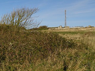
Royal Air Force Portland or more simply RAF Portland is a former Royal Air Force and ROTOR radar station on the Isle of Portland, Dorset, England. Located close to the Verne Citadel and East Cliff, the station was established in the 1950s as part of a nationwide air defence radar system built by the British Government during the Cold War. The station became a scheduled monument in 2004 and is now the site of the community farm, Fancy's Family Farm.

Freshwater Bay is a bay on the east side of the Isle of Portland, Dorset, England, south from Church Ope Cove and between the villages of Wakeham and Southwell. It forms part of the Jurassic Coast.

Folly Pier Waterworks was a 19th-century waterworks on the Isle of Portland, Dorset, England. It was located at East Weares, the east side of Portland, below HM Prison Portland, which it supplied water for. Today, only the foundations and walls of the reservoirs survive. The waterworks was named after Folly Pier, a pier once used for the transporting of Portland stone by sea.

NCI Portland Bill is a National Coastwatch Institution (NCI) lookout station on the Isle of Portland, Dorset, England. The station is situated 50 metres above sea level on the cliff edge, half a mile north of the tip of Portland Bill. It is located close to the Old Higher Lighthouse.

East Weare Camp is a former 19th-century detention barracks on the Isle of Portland in Dorset, England. It is located at East Weares, overlooking Portland Harbour and East Weare Battery. The camp became Grade II Listed in 1978. Both East Weare Battery and East Weare Camp remain on the private property of Portland Port Ltd, and have not been opened to the public.

Merchant's Railway was a horse drawn and cable operated incline railway on the Isle of Portland, Dorset, England, built for the stone trade on the island. It was the earliest railway in Dorset, opening in 1826. The railway ran two miles from many working quarries at the north of Tophill, along the edge of Verne Hill, to a pier at Castletown, from where the Portland stone was shipped. It was in operation from 1826 to 1939. Since becoming disused the original path of the railway has become a popular public footpath.

Verne Heavy Anti-Aircraft Battery is a World War II anti-aircraft battery on the Isle of Portland, Dorset, England. It is located on private property in the north-east area of the island, south of the Verne Citadel. The battery became a scheduled monument in March 2019.
