
The Isle of Portland is a tied island, 6 kilometres (4 mi) long by 2.7 kilometres (1.7 mi) wide, in the English Channel. The southern tip, Portland Bill lies 8 kilometres (5 mi) south of the resort of Weymouth, forming the southernmost point of the county of Dorset, England. A barrier beach called Chesil Beach joins Portland with mainland England. The A354 road passes down the Portland end of the beach and then over the Fleet Lagoon by bridge to the mainland. The population of Portland is 13,417.

Chesil Beach in Dorset, England is one of three major shingle beach structures in Britain. Its name is derived from the Old English ceosel or cisel, meaning "gravel" or "shingle". It runs for a length of 29 kilometres (18 mi) from West Bay to the Isle of Portland and in places is up to 15 metres (50 ft) high and 200 metres (660 ft) wide. Behind the beach is the Fleet, a shallow tidal lagoon. Both are part of the Jurassic Coast and a UNESCO World Heritage Site, and together form an SSSI and Ramsar Site.

Weymouth and Portland was a local government district and borough in Dorset, England from 1974 to 2019. It consisted of the resort of Weymouth and the Isle of Portland, and includes the areas of Wyke Regis, Preston, Melcombe Regis, Upwey, Broadwey, Southill, Nottington, Westham, Radipole, Chiswell, Castletown, Fortuneswell, Weston, Southwell and Easton; the latter six being on the Isle of Portland.

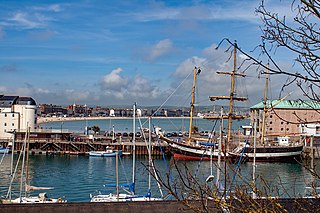
Portland Harbour is located beside the Isle of Portland, Dorset, on the south coast of England. Construction of the harbour began in 1849; when completed in 1872, its 520-hectare (1,300-acre) surface area made it the largest human-made harbour in the world, and remains one of the largest in the world today. It is naturally protected by Portland to the south, Chesil Beach to the west and mainland Dorset to the north. It consists of four breakwaters — two southern and two northern. These have a total length of 4.57 km (2.84 mi) and enclose approximately 1,000 ha of water.

Wyke Regis is a village in south Dorset, England. The village is part of the south western suburbs of Weymouth, on the northern shore of Portland Harbour and the south-eastern end of Chesil Beach. Wyke is 15 kilometres (9 mi) south of the county town, Dorchester. The village has a population of around 5,500.

South Dorset is a constituency represented in the House of Commons of the UK Parliament since 2010 by Richard Drax, a Conservative. The constituency was created as a consequence of the Redistribution of Seats Act 1885, although the area covered has changed since then.

Newton's Cove is a small cove, 0.5 kilometres (0.3 mi) south of Weymouth, Dorset, England. Overlooking Portland Harbour, the cove is close to Nothe Gardens and the Nothe Fort.

The Portland Branch railway refers to a group of lines on the Isle of Portland in the English county of Dorset. The first was the Portland Railway, in fact a tramway with a counterbalanced rope worked incline. It opened in 1826. It was followed by the Weymouth and Portland Railway, which connected to the main line of the Great Western Railway at Weymouth. It opened in 1865. From the late 1840s until 1872 Portland Breakwater was built, a prodigious construction task that created a very large safe harbour. It was decided to provide a railway connection to the breakwater, which was used as a pier for bunkering ships. This was constructed by the LSWR and the GWR jointly, and opened in 1876. The fourth line was the Easton and Church Hope Railway. This line was conceived as a simple descent to bring stone down from quarries to a new jetty at Church Hope, but after their line was authorised in 1867, the Company delayed useful construction, and a change of plan followed, with several Acts of Parliament authorising modifications to the route and extension of time. It finally opened in 1900.
Weymouth is a sea-side town and civil parish in the Dorset district, in the ceremonial county of Dorset, on the English Channel coast of England. Situated on a sheltered bay at the mouth of the River Wey, 11 km (7 mi) south of the county town of Dorchester, Weymouth had a population of 53,427 in 2021. It is the third-largest settlement in Dorset after Bournemouth and Poole. The greater Weymouth urban area has a population of 72,802.
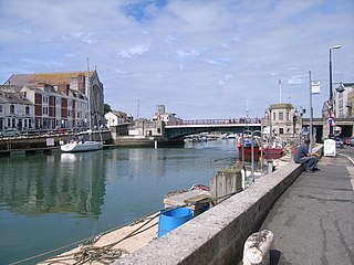
Weymouth Harbour is a harbour at the seaside town of Weymouth in Dorset, southern England. It has a 17th-century waterfront.
There are eight settlements on the Isle of Portland, Dorset, England, the largest of which are Fortuneswell in Underhill and Easton on Tophill. The other villages of Weston, Southwell, Wakeham and the Grove also occupy Tophill, and Castletown and Chiswell are the other villages in Underhill.

The Rodwell Trail is a short-distance footpath that runs from Wyke Regis to the town centre of Weymouth in Dorset – a distance of 3.5 kilometres. The trail, opened in 2000, travels along the former route of the Weymouth and Portland Railway. The section from near Sandsfoot Castle to Ferry Bridge is part of the South West Coast Path. The route follows part of the Jurassic Coast, and Sites of Special Scientific Interest. It is named after a neighbourhood of Weymouth which it passes through.

Wyke Regis Training Area is an army training area primarily located in the parish and town of Chickerell, but near to the parish of Wyke Regis in neighbouring Weymouth, Dorset, England. The training area is located at three different sites. It is part of the Ministry of Defence's Defence Training Estate (DTE), which covers 240,000 hectares of land across the country, used to train armed forces. Although mainly used by the army, the training area has allowed an increasing amount of public use of both the climbing facilities and adventure training over the last few years. When the firing range is in use, signs, restriction gates and red flags are used to require walkers to divert inland around the back of the range before returning to the Coastal Path.
The Great Storm of 1824 was a hurricane force wind and storm surge that affected the south coast of England from 22 November 1824.

Weymouth Town Bridge is a lifting bascule bridge in Weymouth, Dorset, England, connecting the formerly separate boroughs of Weymouth and Melcombe Regis. The bridge can be lifted to allow boats access to the inner backwater of Weymouth Harbour, known as Weymouth Marina. The bridge, opened in 1930, is the sixth to have been built across the harbour since 1597 and has been Grade II Listed since 1997. Today, the hydraulically-operated bridge is raised every two hours, 363 days of the year.
All Saints Church is a Church of England church of 15th-century origin in Wyke Regis, Weymouth, Dorset, England. Built largely of Portland stone, the Royal Commission on the Historical Monuments of England have described the church as a "remarkably consistent and unchanged 15th-century design". It has been a Grade I listed building since 1953. Facing Wyke Road from the modern cemetery opposite the church is the Wyke Regis War Memorial, erected in 1919.

The Wyke Regis War Memorial is a World War I war memorial located in Wyke Regis, Weymouth, Dorset, England. Facing Wyke Road from the edge of Wyke Regis Cemetery, the memorial has been Grade II listed since December 2016.
There are many Grade II listed buildings in the county of Dorset. This is a list of them.
The economy of the County of Dorset in South West England was worth £16.189 billion to the UK economy in 2013.

Wyke Regis Methodist Church is a former Methodist church in Wyke Regis, Dorset, England. Designed by Ford & Slater of Burslem, it was built in 1903 and remained in use until 2021.


