
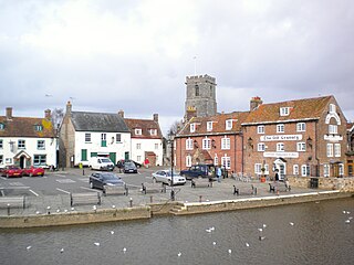
Corfe Castle is a village and civil parish in the English county of Dorset. It is the site of a ruined castle of the same name. The village and castle stand over a gap in the Purbeck Hills on the route between Wareham and Swanage. The village lies in the gap below the castle and is around four miles (6.4 km) south-east of Wareham, and four miles (6.4 km) north-northwest of Swanage. Both the main A351 road from Lytchett Minster to Swanage and the Swanage Railway thread their way through the gap and the village.

The Studland and Godlingston Heaths NNR is located on the Isle of Purbeck in the English county of Dorset. It borders Studland Bay on the south side of Poole Harbour, between the settlements of Swanage and Sandbanks. Extending to 631ha, it is owned and managed by the National Trust following the Bankes bequest of the Kingston Lacy estate. Studland & Godlingston Heath is designated as one of only 35 "spotlight reserves" in England by Natural England in the list of national nature reserves in England and is listed as a Site of Special Scientific Interest (SSSI).

Swanage is a coastal town and civil parish in the south east of Dorset, England. It is at the eastern end of the Isle of Purbeck and one of its two towns, approximately 6+1⁄4 miles (10 km) south of Poole and 25 miles (40 km) east of Dorchester. In the 2011 census the civil parish had a population of 9,601. Nearby are Ballard Down and Old Harry Rocks, with Studland Bay and Poole Harbour to the north. Within the parish are Durlston Bay and Durlston Country Park to the south of the town. The parish also includes the areas of Herston, just to the west of the town, and Durlston, just to the south.
The Isle of Purbeck is a peninsula in Dorset, England. It is bordered by water on three sides: the English Channel to the south and east, where steep cliffs fall to the sea; and by the marshy lands of the River Frome and Poole Harbour to the north. Its western boundary is less well defined, with some medieval sources placing it at Flower's Barrow above Worbarrow Bay. John Hutchins, author of The History and Antiquities of the County of Dorset, defined Purbeck's western boundary as the Luckford Lake stream, which runs south from the Frome. According to writer and broadcaster Ralph Wightman, Purbeck "is only an island if you accept the barren heaths between Arish Mell and Wareham as cutting off this corner of Dorset as effectively as the sea." The most southerly point is St Alban's Head.
Wareham is a historic market town and, under the name Wareham Town, a civil parish, in the English county of Dorset. The town is situated on the River Frome eight miles (13 km) southwest of Poole.

Lytchett Matravers is a large village and civil parish in Dorset, England. The 2011 census recorded the parish as having 1,439 households and a population of 3,424.

Upton is a town in south-east Dorset, England. Upton is to the east of Holton Heath and Upton Heath, and to the north of the Poole suburb of Hamworthy. It is the second largest town in the Purbeck Hills.
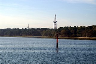
Wytch Farm is an oil field and processing facility in the Purbeck district of Dorset, England. It is the largest onshore oil field in Western Europe. The facility, taken over by Perenco in 2011, was previously operated by BP. It is located in a coniferous forest on Wytch Heath on the southern shore of Poole Harbour, two miles (3.2 km) north of Corfe Castle. Oil and natural gas (methane) are both exported by pipeline; liquefied petroleum gas is exported by road tanker.

Dorset is a rural county in south west England. Its archaeology documents much of the history of southern England.

South Dorset is a constituency represented in the House of Commons of the UK Parliament since 2024 by Lloyd Hatton, of the Labour Party. The constituency was created as a consequence of the Redistribution of Seats Act 1885, although the area covered has changed since then.
Mid Dorset and North Poole is a constituency represented in the House of Commons of the UK Parliament since 2024 by Vikki Slade, a Liberal Democrat.

Dorset is a county located in the middle of the south coast of England. It lies between the latitudes 50.512°N and 51.081°N and the longitudes 1.682°W and 2.958°W, and occupies an area of 2,653 km2. It spans 90 kilometres (56 mi) from east to west and 63 kilometres (39 mi) from north to south.

The Dorset Heaths form an important area of heathland within the Poole Basin in southern England. Much of the area is protected.
