
Cockshoot Broad is a 5-hectare (12-acre) nature reserve north-east of Norwich in Norfolk. It is managed by the Norfolk Wildlife Trust. It is part of the Bure Broads and Marshes Site of Special Scientific Interest, and the Broadland Ramsar site and Special Protection Area, and The Broads Special Area of Conservation. It is also part of the Bure Marshes National Nature Reserve and Nature Conservation Review site, Grade I.
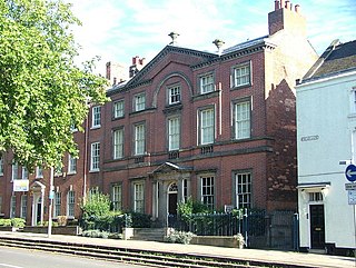
Pickford's House Museum of Georgian Life and Costume is in Derby, England. It is named after architect Joseph Pickford, who built it as his family home in 1770. It was opened as a museum in 1988. The building is Grade I listed.

Tue Brook House, 695 West Derby Road, Liverpool was built in 1615 as a farmhouse. It is now owned by a local family. It is thought to have been originally owned by John Mercer, a yeoman farmer and during the Victorian period was the home and workshop of a Mr.Fletcher, a wheelwright. Some parts of the building contain sections of its original "wattle and daub" construction, which can be seen through glass panels. Also containing a priest hide located in the chimney breast between two of the bedrooms. The house is currently owned by a local Liverpool family.

Sycharth is a motte and bailey castle and town in Llansilin, Powys, Wales. Until 1996 Sycharth was in the historic county of Denbighshire, but was then transferred to the Shire area of Montgomeryshire within Powys. Sycharth Castle was the birthplace of Owain Glyndŵr.

Glovers Harbour, formerly known as Thimble Tickle(s), is an unincorporated community and harbour in the Canadian province of Newfoundland and Labrador. It is located in Notre Dame Bay on the northern coast of the island of Newfoundland. As a local service district, it is led by an elected committee that is responsible for the delivery of certain essential services. It is delineated as a designated place for statistical purposes.
The Williams Lake First Nation is a First Nations government of the Secwepemc (Shuswap) Nation, located in the Cariboo region of the Central Interior region of the Canadian province of British Columbia, at the city of Williams Lake. It was created when the government of the then-Colony of British Columbia established an Indian reserve system in the 1860s. It is a member government of the Northern Shuswap Tribal Council. Its main Indian Reserve is Williams Lake Indian Reserve No. 1, a.k.a. "Sugarcane" or "The Cane" or "SCB".

Bescot is an area of Walsall in the West Midlands of England. It is served by Bescot Stadium railway station, adjacent to which is Bescot depot where locomotives are maintained. The Banks's Stadium was built in 1990 for Walsall F.C. The area is bisected by the M6 motorway, including its 'Junction 9', where it meets the A461 which leads to Pleck and Wednesbury. The River Tame also runs through the area.
Route 350, commonly known as Botwood Highway, is a side highway in Central Newfoundland that leads from the Trans-Canada Highway in Bishop's Falls to Botwood, Point Leamington and Leading Tickles. It is 70.7 kilometres (43.9 mi) in length and contains several side roads to communities located off the route, such as Peterview, and Route 352 that leads to Point of Bay and the Cottrell's Cove-Fortune Harbour area. Route 350-17 branches off in Point Leamington and connects the small community of Pleasantview to the main route. Route 350 continues on from Point Leamington for another 25 km north to Leading Tickles where the road officially ends. Along the way there is another short road connecting Glovers Harbour to the main route as well.

Leading Tickles is a town in the Canadian province of Newfoundland and Labrador. In 2021, the town had a population of 296, down from 407 in the Canada 2006 Census. It is located approximately 25 km Northwest of Point Leamington on the shores of Notre Dame Bay. The town boasts spectacular scenery especially in spring and early summer when many icebergs pass just off the coast.

A695 road is a road in Northern England linking Newcastle upon Tyne, Tyne and Wear, with Hexham, Northumberland.

Port Dundas is an area of Glasgow, Scotland, located 1 mile (1.6 km) to the north of the city centre. It lies to the north of Cowcaddens, and to the west of Sighthill, with Hamiltonhill and Possilpark to the north-west.

The Goodyear chimney was an iconic landmark on the Goodyear factory on Stafford Road, Wolverhampton, England. It was 200 feet (60 m) high and weighed 3,000 long tons (3,000 t).
Parc is the name of an ancient mansion found near the village of Croesor in the community of Llanfrothen near Penrhyndeudraeth, in Gwynedd, Wales. The former mansion has been in ruins since the end of the 17th century when the resident Anwyl Family moved to Llugwy.
"The older abode of the Anwyls, Parc, near Penrhyndeudraeth, although long neglected, has not altogether disappeared. It is approached by a drive of more than a mile in length. In front of the site of the house are four terraces, 150 feet long by 50 wide, supported by walls 12 feet high.
The part of the house still standing, built in 1671, is said to have been the ball-room. On the gable are curious large round chimneys. On either side of the front door are pieces of beautifully carved stone, formerly gilded, from the chimney-piece in the dining-hall; and one sees here and there, sometimes even in the walls of the present sheepfolds, mullions from the windows in freestone. At the back of the old mansion there are the ruins of a stone bath with seats round it and steps to descend. The "gate-house" (lodge) is still standing, but much dilapidated."
Norman's Bay is a local service district and designated place in the Canadian province of Newfoundland and Labrador. It is an isolated community at the head of Norman Bay, an extension of Martin Bay. The population of the community was 15 in the 2021 census.
Cold Bay Air Force Station is a closed United States Air Force General Surveillance Radar station. It is located 625 miles (1,006 km) southwest of Anchorage, Alaska.
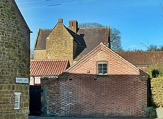
Ab Kettleby Manor is an early 17th-century house in the village of Ab Kettleby, Leicestershire. Built of ironstone with a central brick chimney the house is cruciform in plan.
Domino is a former settlement on the Island of Ponds in Labrador. Domino is located on the east side of a cove named Salmon Bight. What remains of the community has been absorbed into the neighbouring settlement of Black Tickle, located on the west side of the cove. The area is sometimes still referred to as Black Tickle–Domino.
Par Zeytun Rural District is a rural district (dehestan) in Meymand District, Firuzabad County, Fars Province, Iran. At the 2006 census, its population was 6,695, in 1,428 families. The rural district has 20 villages.
Chimney Gulch is a valley and arroyo in the Diablo Range, in Santa Clara, California. Its mouth is at an elevation of 932 feet / 284 meters at its confluence with an unnamed creek tributary to East Fork Pacheco Creek that runs westward down below Hagerman Peak to join the East Fork about an eighth of a mile below its confluence with Chimney Gulch. The head of Chimney Gulch and the source of the stream, is a pond south of the Fifield Ranch on the northeast slope of Hagerman Peak at 37°06′52″N121°13′55″W.
