The North-West Frontier Province was a province of British India and later of Pakistan. It was established on 9 November 1901 from the north-western districts of the Punjab Province and known by this name until 2010, when it was redesignated as the province of Khyber Pakhtunkhwa on 19 April 2010 following the passing of the Eighteenth Amendment to the Constitution of Pakistan by erstwhile President Asif Ali Zardari.

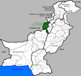
Waziristan is a mountainous region covering the former FATA agencies of North Waziristan and South Waziristan which are now districts of Khyber Pakhtunkhwa province of Pakistan. Waziristan covers some 11,585 square kilometres (4,500 sq mi). The area is populated by ethnic Pashtuns. It is named after the Wazir tribe. The language spoken in the valley is Pashto, predominantly the Waziri dialect. The region forms the southern part of Pakistan's Federally Administered Tribal Areas, which is now part of Khyber Pakhtunkhwa province.
The Mohmand or Momand tribe is one of the most prominent Pashtun tribes. They are descended from the 1st Son of Daulatyar and 2nd son, Daudzai, according to Pashtun historical literature. They are based primarily in the eastern districts of Nangarhar Province, Afghanistan, and the Mohmand district of the Khyber Pakhtunkhwa Province of Pakistan, bordering Nangarhar to the east.

North Waziristan District is a district in Bannu Division of Khyber Pakhtunkhwa province in Pakistan. It is the northern part of Waziristan, a mountainous region of northwest Pakistan, bordering Afghanistan and covering 4,707 square kilometres (1,817 sq mi). The capital city of North Waziristan is Miramshah.

Orakzai District is a district in Kohat Division of Khyber Pakhtunkhwa province in Pakistan. Until 2018, it was an agency of Federally Administered Tribal Areas. With the merger of FATA with Khyber Pakhtunkhwa, it became a district. Before to 1973, it was part of FR Kohat.

The Turi or Torai are a sub-tribe of the Karlani Pashtun tribe, inhabiting the Kurram Valley, in Kurram Agency in the Federally Administered Tribal Areas of Pakistan, with a smaller number living across the Durand line in the Paktia province of Afghanistan. They speak Pashto and are adherents of the Twelver Shia sect of Islam.

South Waziristan District is a district in Dera Ismail Khan Division of Khyber Pakhtunkhwa and the southern part of Waziristan, a mountainous region of northwest Pakistan, that covers some 11,585 km2 (4,473 mi²). Waziristan comprises the area west and southwest of Peshawar between the Tochi River to the north and the Gomal River to the south. The region was an independent tribal territory from 1893, remaining outside of British-ruled empire and Afghanistan. Tribal raiding into British-ruled territory was a constant problem for the British, requiring frequent punitive expeditions between 1860 and 1945. Troops of the British Raj coined a name for this region "Hell's Door Knocker" in recognition of the fearsome reputation of the local fighters and inhospitable terrain. The capital city of South Waziristan is Wanna. South Waziristan is divided into the three administrative subdivisions of Ladha, Sarwakai, and Wanna. These three subdivisions are further divided into eight Tehsils: Ladha, Makin, Sararogha, Sarwakai, Tiarza, Wanna, Barmal, and Toi Khula.

Khyber District is a district in Peshawar Division of Khyber Pakhtunkhwa province in Pakistan. Until 2018, it was an agency of Federally Administered Tribal Areas, with merger of FATA with Khyber Pakhtunkhwa, it became a district. It ranges from the Tirah valley down to Peshawar. It borders Nangarhar Province to the west, Orakzai District to the south, Kurram District to south west, Peshawar to the east and Mohmand District in north.

Mohmand District is a district in Peshawar Division of Khyber Pakhtunkhwa province in Pakistan. Until 2018, it was an agency of Federally Administered Tribal Areas, with merger of FATA with Khyber Pakhtunkhwa, it became a district. It was created as an agency in 1951. Mohmand is bordered by Bajaur District to the north, Khyber District to the south, Malakand and Charsadda districts to the east and Peshawar district to the southeast.
The Halimzai is Sub-tribe of Mohmand. The Halimzai are the largest sub-tribe or clan of the Mohmand Pashtun tribe.

Dera Ismail Khan Subdivision formerly Frontier Region Dera Ismail Khan is a subdivision in Khyber Pakhtunkhwa province of Pakistan. The region is named after Dera Ismail Khan District which lies to the east and also borders South Waziristan to the north, Dera Ghazi Khan and Musa Khel to the south and Zhob to the west. It is administered by the district coordination officer (DCO) of Dera Ismail Khan District. The main village of the frontier region is Darazinda, which borders South Waziristan.

The Federally Administered Tribal Areas was a semi-autonomous tribal region in northwestern Pakistan that existed from 1947 until being merged with neighbouring province Khyber Pakhtunkhwa in 2018. It consisted of seven tribal agencies (districts) and six frontier regions, and were directly governed by Pakistan's federal government through a special set of laws called the Frontier Crimes Regulations. It bordered Pakistan's provinces of Khyber Pakhtunkhwa, Balochistan, and Punjab to the east, south, and south-east respectively, and Afghanistan's provinces of Kunar, Nangarhar, Paktia, Khost and Paktika to the west and north. The territory is almost exclusively inhabited by the Pashtun, who also live in the neighbouring provinces of Khyber Pakhtunkhwa and Northern Balochistan, and straddle across the border into Afghanistan. They are mostly Muslim.

Peshawar Subdivision formerly Frontier Region Peshawar is a subdivision in Khyber Pakhtunkhwa province of Pakistan. The region is named after Peshawar District which lies to the north and west and also borders Nowshera District to the east and Kohat Subdivision to the south. It is administered by the district coordination officer (DCO) of Peshawar District. The main settlement in Peshawar division is Kalakhel. GDP nominal 7 billion US dollars
Kala Khel is a clan of Tirah Adam Khel. Adam Khel is a sub-tribe of Afridi that has originated from the Karlanee or Karlani group of Pashtuns. The Kala Khel clan of Tirah Adam Khel inhabits in FR Peshawar region and in Bara and Torghar as well. It can be found on Google Maps at 33.728623N,71.55256E and Tirah valley of Khyber agency at 33.73N, 71.01E.

Torawari(طوراوڑی) is a village with a small population. Torawari was a part of Federally Admisinstred Tribal Areas (F.A.T.A). But recently in 2019 bill was passed under the government of Prime Minister Imran Khan and he approved it. Now its Torawari, Khyber PakhtunKhwa, Pakistan. Torawari which is located in the Tehsil Thal Hangu District in Khyber Pakhtunkhwa, Pakistan.
Barang Subdivision is a subdivision located in Bajaur District, Khyber Pakhtunkhwa, Pakistan.
Landi Kotal is a subdivision located in Khyber District, Khyber Pakhtunkhwa, Pakistan. The population is 274,409 according to the 2017 census.
Aka Khel or Akakhel is an area of Landi Kotal Tehsil, Khyber Agency, Federally Administered Tribal Areas, Pakistan located in the Tirah Valley.
Ghotak Eisa Khel Eisa Khel, also Ghotak Isa Khel, Ghotak Issa Khel or simply Ghotak, is the main place of the Eisa khel or Isa khel, the capital and largest village of the Upper Orakzai Subdivision, now part of the Khyber Pakhtunkhwa province, Pakistan.


