
Apurímac is a region in southern-central Peru. It is bordered on the east by the Cusco Region, on the west by the Ayacucho Region, and on the south by the Arequipa and Ayacucho regions. The region's name originates from the Quechua language and means "where the gods speak" in reference to the many mountains of the region that seem to be talking to each other.
The Cotabambas Province is a province located in the Apurímac Region of Peru. The province has a population of 44,028 inhabitants. The capital of this province is the city of Tambobamba.

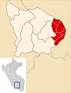
The Abancay Province is one of seven provinces of the Apurímac Region in Peru. The capital of the province is the city of Abancay.

Antabamba Province is one of the seven provinces of the Apurímac Region in Peru. The capital of the province is the city of Antabamba.
Urququcha is a lake in Peru located in the Apurímac Region, Grau Province, Curpahuasi District. It is situated west of Chinaqucha, at the foot of Waman Ch'arpa.
Tipiqucha is a lake in Peru located in the Apurimac Region, Grau Province, Chuquibambilla District. It lies west of the lake Pachachaka (Pachachaca).

Wayunka is a mountain in the Wansu mountain range in the Andes of Peru, about 5,300 metres (17,388 ft) high. It is situated in the Apurímac Region, Antabamba Province, Oropesa District, northwest of the mountains Waytani and Chankuwaña.
Puka Urqu is a mountain in the Wansu mountain range in the Andes of Peru, about 4,950 metres (16,240 ft) high. It is situated in the Apurímac Region, Antabamba Province, Oropesa District. Puka Urqu lies west of Hatunqullpa and northeast of Millu.
Kimsaqucha is a mountain in the Andes of Peru, about 5,000 metres (16,404 ft) high. It is situated in the Apurímac Region, Antabamba Province, Oropesa District, and in the Grau Province, Mamara District.
T'alla Kallanka is a mountain in the Wansu mountain range in the Andes of Peru, about 5,000 metres (16,404 ft) high. It is situated in the Apurímac Region, Antabamba Province, Oropesa District. T'alla Kallanka lies west of Millu and northwest of Mina Q'asa.
Q'illu Pachaka is a mountain in the Wansu mountain range in the Andes of Peru, about 5,000 metres (16,404 ft) high. It is situated in the Apurímac Region, Antabamba Province, Oropesa District. Q'illu Pachaka lies east of Wank'ayuq Saywa and southeast of Hatun Qillqa.
Wank'ayuq Saywa is a mountain in the Wansu mountain range in the Andes of Peru, about 5,000 metres (16,404 ft) high. It is situated in the Apurímac Region, Antabamba Province, in the districts of Antabamba and Oropesa. Wank'ayuq Saywa lies west of Q'illu Pachaka and southeast of Hatun Qillqa.
Pachak Pata is a mountain in the Wansu mountain range in the Andes of Peru, about 4,800 metres (15,748 ft) high. It is situated in the Apurímac Region, Antabamba Province, Antabamba District. Pachak Pata lies west of Muntirayuq and northwest of Saywa Punta.
Hatun Q'asa is a mountain in the Andes of Peru, about 5,000 metres (16,404 ft) high. It is situated in the Apurímac Region, Antabamba Province, Oropesa District. It lies south of Mallmanya, northwest of Sura Kallanka and southeast of Kimsaqucha. East of Hatun Q'asa there is a lake named Suraqucha (Soracocha).
Sura Kallanka is a mountain in the Andes of Peru, about 5,000 metres (16,404 ft) high. It is situated in the Apurímac Region, Antabamba Province, Oropesa District. It lies southeast of Kimsaqucha, Mallmanya and Hatun Q'asa. North of Sura Kallanka there is a lake named Suraqucha (Soracocha).
Mina Q'asa is a mountain in the Wansu mountain range in the Andes of Peru, about 5,100 metres (16,732 ft) high. It is situated in the Apurímac Region, Antabamba Province, Oropesa District. Mina Q'asa lies south of Puka Urqu and southeast of Millu.
Yana Urqu is a mountain in the north of the Wansu mountain range in the Andes of Peru, about 5,000 m (16,404 ft) high. It is situated in the Apurímac Region, Antabamba Province, Oropesa District. Yana Urqu lies southwest of Willkarana and Kisu Qutu.
Misa Urqu is a mountain in the north of the Wansu mountain range in the Andes of Peru, about 4,800 m (15,748 ft) high. It is situated in the Apurímac Region, Antabamba Province, Oropesa District. Misa Urqu lies north of Kisu Qutu on a ridge west of Willkarana.
Waman Ch'arpa is a mountain in the Andes of Peru, about 4,600 metres (15,092 ft) high. It is located in the Apurímac Region, Abancay Province, Lambrama District, and in the Grau Province, Curpahuasi District. It lies west of the lakes named Chinaqucha and Urququcha.

