Related Research Articles
Limestone Township is a civil township of Alger County in the U.S. state of Michigan. The population was 392 in 2020.

Breen Township is a civil township of Dickinson County in the U.S. state of Michigan. The population was 471 at the 2020 census.

Felch Township is a civil township of Dickinson County in the U.S. state of Michigan, named in honor of Alpheus Felch. The population was 687 at the 2020 census.

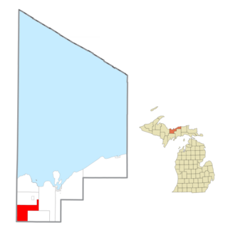
Norway Township is a civil township of Dickinson County in the U.S. state of Michigan. The population was 1,535 at the 2020 census.

Watersmeet Township is a civil township of Gogebic County in the Upper Peninsula of the U.S. state of Michigan. The population was 1,456 in 2020.

Hematite Township is a civil township of Iron County in the U.S. state of Michigan. As of the 2000 census, the township population was 352, and by 2020 its population declined to 269. The township is named for the masses of hematite iron ore in the rocks prevalent in the area.

Iron River Township is a civil township of Iron County in the U.S. state of Michigan. The population was 1,585 at the 2000 census and 1,052 in 2020.
Bark River is a 23.7-mile-long (38.1 km) river on the Upper Peninsula of the U.S. state of Michigan. The river flows into Green Bay on Lake Michigan in Ford River Township about 15 miles (24 km) southwest of Escanaba at 45°34′22″N87°14′34″W.
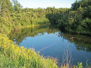
The Mineral River is an 18.7-mile-long (30.1 km) tributary of Lake Superior on the western Upper Peninsula of Michigan in the United States. It flows for its entire length in western Ontonagon County, rising in the Ottawa National Forest and flowing generally northward to meet Lake Superior about 11 miles (18 km) west-southwest of Ontonagon. The United States Board on Geographic Names settled on "Mineral River" as the stream's name in 1976; according to the Geographic Names Information System it has also been known historically as "Beaver Creek".
The Days River is a 30.1-mile-long (48.4 km) river on the Upper Peninsula of the U.S. state of Michigan.
Millersville is an unincorporated community in Christian County, Illinois, United States. It lies at 39°27′4″N89°9′29″W, at an elevation of 656 feet.
The Iron River is a 17.1-mile-long (27.5 km) river in Iron County, Michigan, in the United States. It flows from northwest to southeast through the city of Iron River to the Brule River. It is part of the Menominee River watershed, flowing to Lake Michigan.
Callon is a neighborhood of the Village of Weston, Marathon County, in the United States. It was an unincorporated community until Weston's incorporation as a village.
Beartrap Creek is a stream in Ashland and Bayfield counties, Wisconsin, in the United States.
Birch Creek is a stream in Menominee County, Michigan, in the United States. It is a tributary of Springer Creek.
Birch Creek is an unincorporated community in Menominee County, in the U.S. state of Michigan.

Boxelder Creek is a stream in Pennington, Meade and Lawrence counties, South Dakota, in the United States. It is a tributary of the Cheyenne River.
Partridge Creek is a stream in Marquette County, Michigan, in the United States.
Plum Creek is a ghost town in Kossuth County, in the U.S. state of Iowa. A railroad station was once located at Plum Creek.
Houghton Point is a cape in Bayfield County, Wisconsin, in the United States.
References
- ↑ U.S. Geological Survey Geographic Names Information System: Choate Creek
- ↑ Chicago and North Western Railway Company (1908). A History of the Origin of the Place Names Connected with the Chicago & North Western and Chicago, St. Paul, Minneapolis & Omaha Railways. p. 55.
46°27′04″N89°17′26″W / 46.45111°N 89.29056°W
| | This Ontonagon County, Michigan location article is a stub. You can help Wikipedia by expanding it. |
| | This article related to a river in Michigan is a stub. You can help Wikipedia by expanding it. |