
The Yukon River is a major watercourse of northwestern North America. The river's source is in British Columbia, Canada, from which it flows through the Canadian Yukon Territory. The lower half of the river lies in the U.S. state of Alaska. The river is 3,190 kilometres (1,980 mi) long and empties into the Bering Sea at the Yukon–Kuskokwim Delta. The average flow is 6,430 m3/s (227,000 ft3/s). The total drainage area is 832,700 km2 (321,500 mi2), of which 323,800 km2 (126,300 mi2) is in Canada. The total area is more than 25% larger than Texas or Alberta.

Lake Buena Vista is a city in Orange County, Florida, United States. It is mostly known for being the mailing address for Walt Disney World—although almost all of the resort facilities, including all four theme parks, are physically located in the adjacent city of Bay Lake. It is one of two Florida municipalities controlled by The Walt Disney Company, the other being Bay Lake. The permanent residential population of Lake Buena Vista was 10 at the 2010 census.
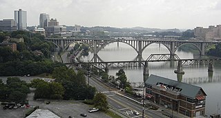
The Tennessee River is the largest tributary of the Ohio River. It is approximately 652 miles (1,049 km) long and is located in the southeastern United States in the Tennessee Valley. The river was once popularly known as the Cherokee River, among other names, as many of the Cherokee had their territory along its banks, especially in eastern Tennessee and northern Alabama. Its current name is derived from the Cherokee village Tanasi.

The Etowah River is a 164-mile-long (264 km) waterway that rises northwest of Dahlonega, Georgia, north of Atlanta. On Matthew Carey's 1795 map the river was labeled "High Town River". On later maps, such as the 1839 Cass County map, it was referred to as "Hightower River", a name that was used in most early Cherokee records.

Ward Creek is a 6.1-mile (9.8 km) eastward-flowing stream in Placer County, California, USA. The creek flows into Lake Tahoe 2.7 miles (4.3 km) south of Tahoe City, California, and has undergone extensive restoration to reduce sediment and surface run-off to maintain the purity of Lake Tahoe.
Wills Creek is a 38.6-mile-long (62.1 km) tributary of the North Branch Potomac River in Pennsylvania and Maryland in the United States.

The San Jacinto River is a 42-mile-long (68 km) river in Riverside County, California. The river's headwaters are in San Bernardino National Forest, but the lower portion of the 765-square-mile (1,980 km2) watershed is urban and agricultural land. As a partially endorheic watershed that is contiguous with other Great Basin watersheds, the western side of the San Jacinto Basin is a portion of the Great Basin Divide.
James Allen "Jumpy" Geathers is a former American football defensive lineman. At the time of his retirement, he was the only active player who played at Wichita State University, who discountinued their football program following their 1986 season, making him the last WSU football player to play in the NFL. Geathers was drafted by the New Orleans Saints with the 42nd overall selection in the 2nd round of the 1984 NFL Draft, making him along with Anthony Jones, the last Shockers drafted in the NFL.

The Opal Creek Wilderness is a wilderness area located in the Willamette National Forest in the U.S. state of Oregon, on the border of the Mount Hood National Forest. It has the largest uncut watershed in Oregon.
Sturgeon River is a 63.6-mile-long (102.4 km) river in the U.S. state of Michigan, flowing mostly southward through Alger County and Delta County counties on the Upper Peninsula.

Catskill Creek is a 46.0-mile-long (74.0 km) tributary of the Hudson River that drains the northeastern Catskill Mountains of the U.S. State of New York. From its source at Franklinton Vlaie in Schoharie County it flows southeast through parts of Albany County and Greene County to its mouth at the village of Catskill on the Hudson River.
Bowery Creek is a 6.0-mile-long (9.7 km) tributary of Catskill Creek north of the Catskill Mountains of New York. Via Catskill Creek, it is part of the Hudson River watershed. Bowery Creek rises east of Windham High Peak in the northern part of the town of Cairo and flows northeast to Catskill Creek west of Freehold.
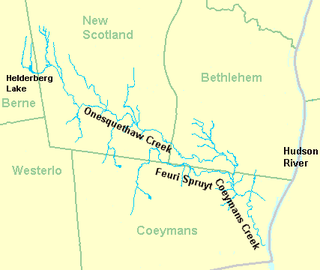
Coeymans Creek is a 7.3-mile-long (11.7 km) tributary of the Hudson River in Albany County, New York in the United States.

Hannacrois Creek is a 20.9-mile-long (33.6 km) tributary to the Hudson River in the U.S. state of New York. From its source in Westerlo it flows through Dunbar Hollows and over Dickinson Falls to the Alcove Reservoir. It then passes through Coeymans Hollow and just into Greene County to its mouth at the Hudson River in Coeymans, New York.

Kinderhook Creek is a 49.0-mile-long (78.9 km) tributary to Stockport Creek, an inlet of the Hudson River in the United States. From its source in Hancock, Massachusetts, the creek runs southwest through the Taconic Mountains into Rensselaer County, New York, and then into Columbia County. It flows through the towns of Stephentown, New Lebanon, Nassau, Chatham, Kinderhook and Stuyvesant to its mouth at Stockport Creek in the town of Stockport.
Claverack Creek is a 17.5-mile-long (28.2 km) tributary to Stockport Creek in Columbia County, New York, in the United States. Its source is in the town of Claverack at the hamlet of Mellenville, and its mouth is at its confluence with Kinderhook Creek to form Stockport Creek, in the town of Stockport.
Taghkanic Creek is a 30.1-mile-long (48.4 km) tributary to Claverack Creek in Columbia County, New York, in the United States. Via Claverack Creek and Stockport Creek, it is part of the Hudson River watershed. Its source is in the town of Hillsdale, and it passes through the towns of Copake, Taghkanic, and Livingston before terminating at Claverack Creek in the town of Greenport.
San Felipe Creek is a stream in Imperial and San Diego Counties of California. It arises in the Volcan Mountains of San Diego County 33°11′57″N116°37′35″W, and runs eastward, gathering the waters of most of the eastern slope of the mountains and desert of the county before it empties into the Salton Sea. It is probably the last remaining perennial natural desert stream in the Colorado Desert region. In 1974, the San Felipe Creek Area was designated as a National Natural Landmark by the National Park Service.
South Carolina Highway 513 (SC 513) is a 8.8-mile-long (14.2 km) state highway in the U.S. state of South Carolina. The highway travels through rural areas of Georgetown County.
Choppee is an unincorporated community in Georgetown County, in the U.S. state of South Carolina.


